DahUlm: a geologist’s tour of Mont Blanc
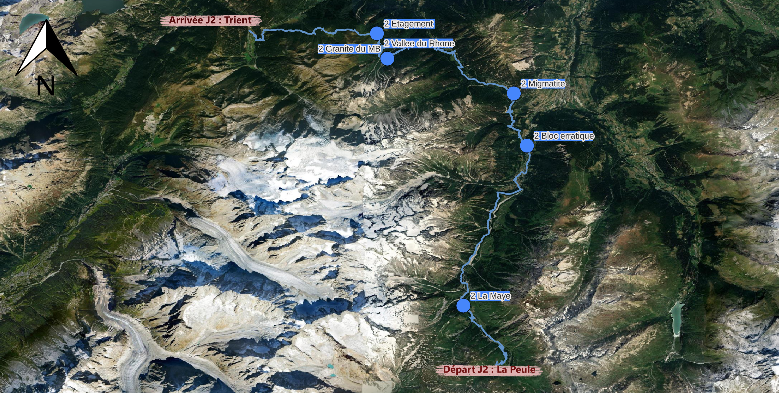
Courmayeur - La PeuleStage 2
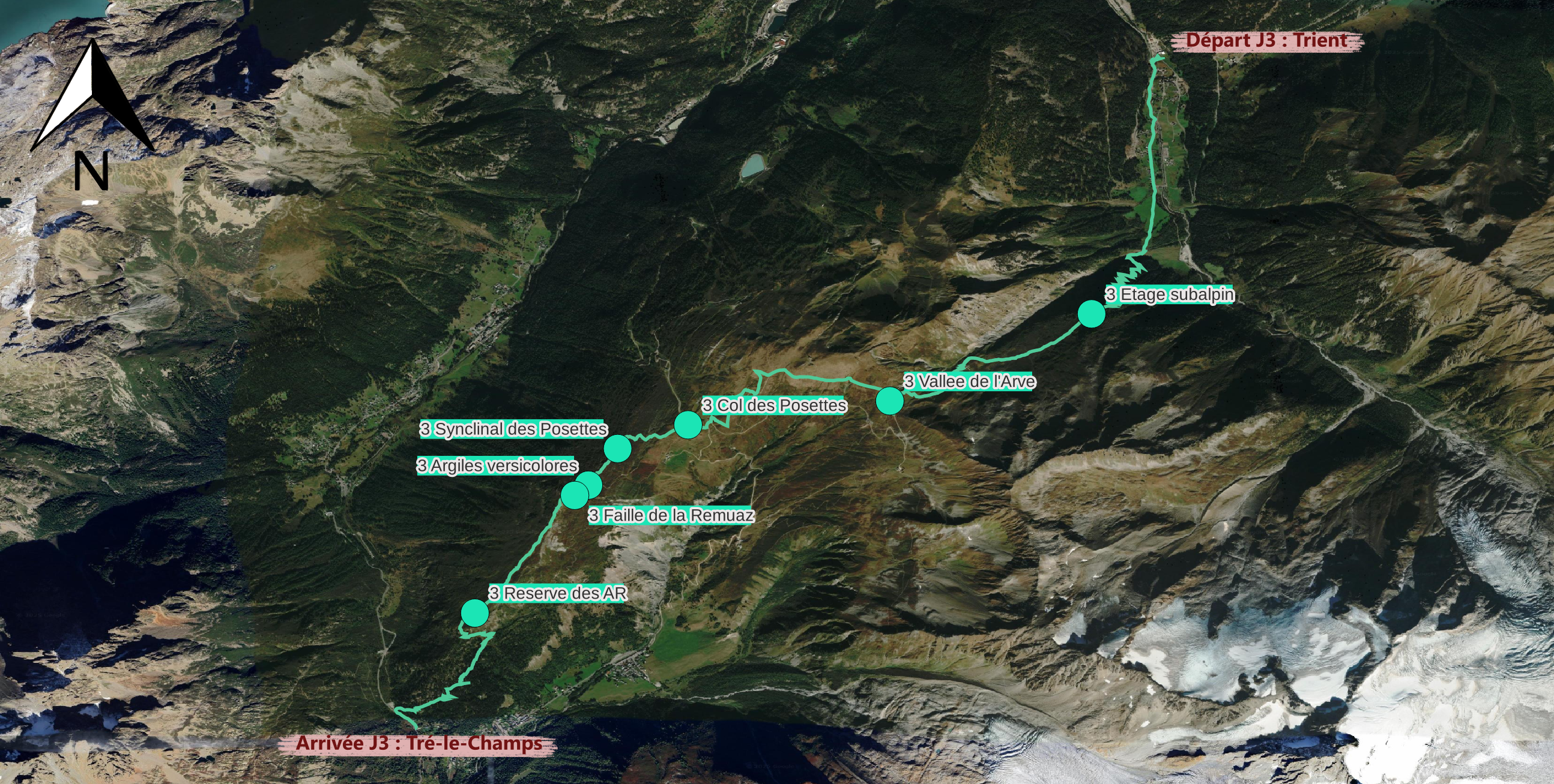
La Peule - TrientStage 3
Trient - Tré le ChampStage 4
Tré le Champ - Les HouchesStage 5
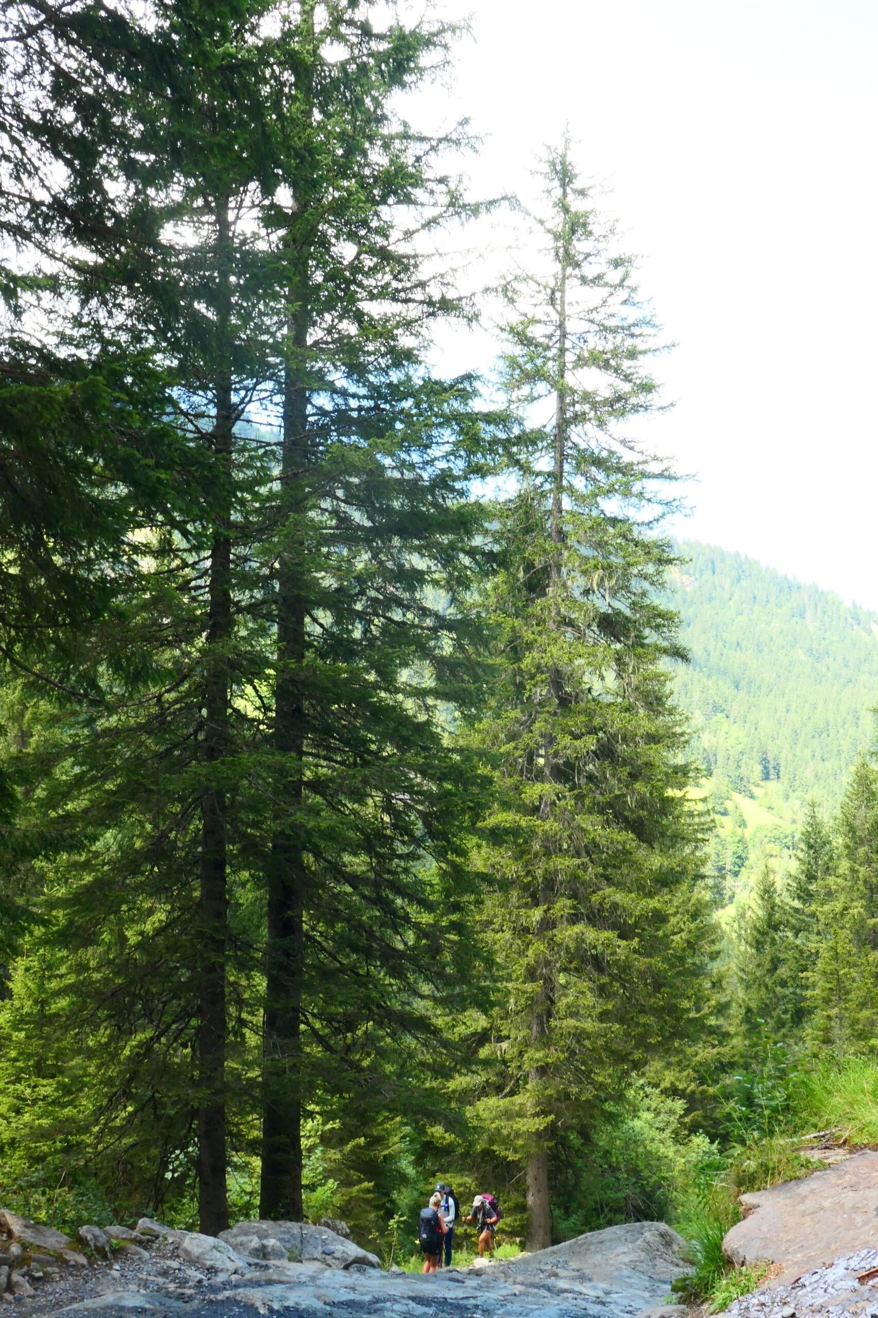
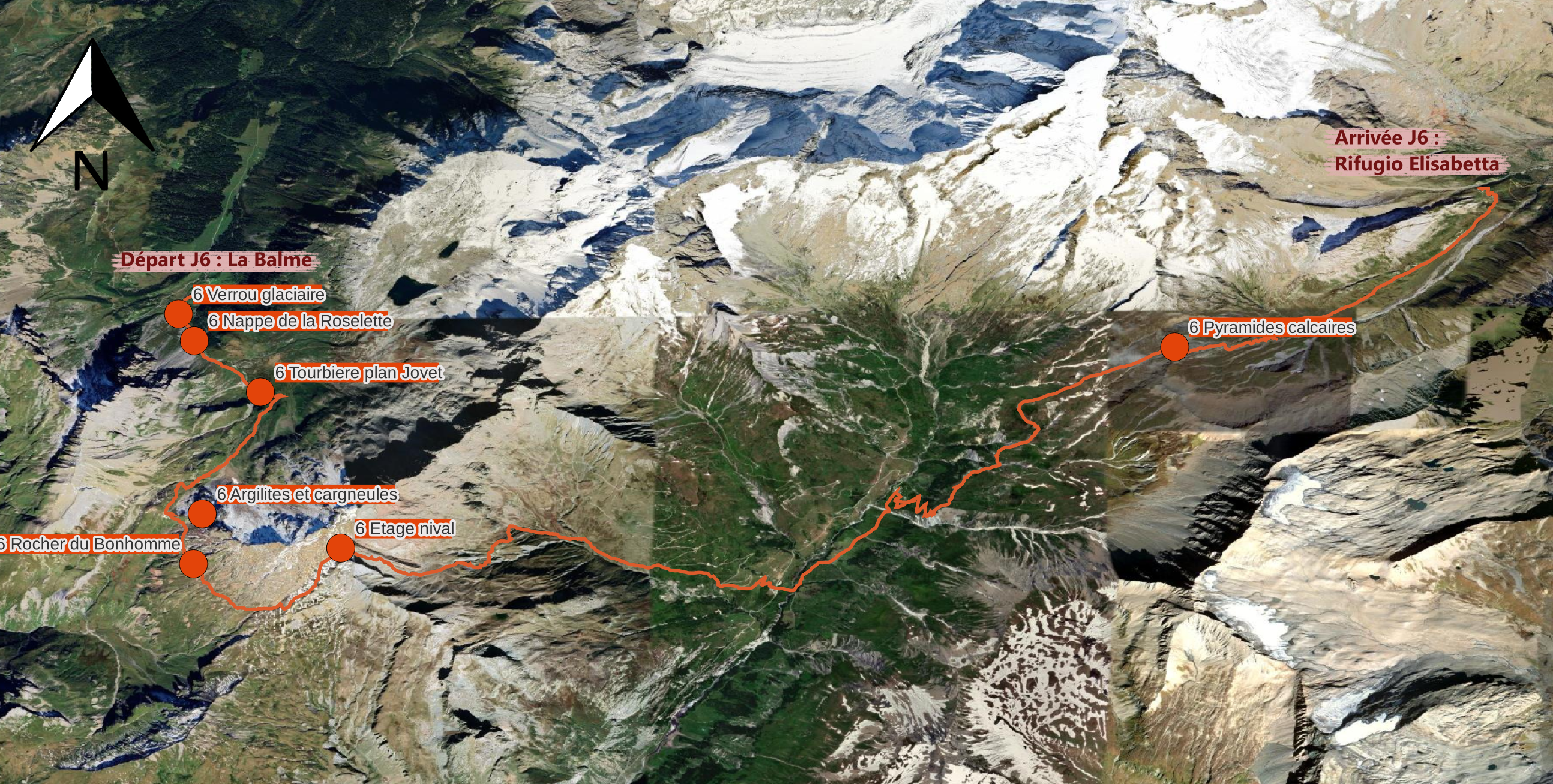
Les Houches - Refuge de la BalmeStage 6
Refuge de la Balme - Rifugio ElizabettaStage 7
Rifugio Elizabetta - CourmayeurBibliographieRemerciements
The Tour du Mont-Blanc is one of the most popular itineraries for hikers in France, Switzerland and Italy. As its name suggests, it circles the Mont-Blanc massif in around 170km, offering a wealth of beautiful scenery and natural wonders. We invite you to retrace the geological history of Mont-Blanc based on observations made along this trail.
DahUlm is a project run by three friends, students in the Geosciences department at the ENS: Angélique Marck, Romane Rizet and Zoé Dubois. It is supported by Amsterre, the geosciences department student association.
We travelled the Tour du Mont-Blanc in 7 stages during the summer of 2024. During these stages, we took photos of panoramas or objects remarkable for the geological history they tell. This is a history that is still being written every day: the changes that the mountains are undergoing as a result of melting ice, increasing urbanisation and over-tourism have had a particular impact on us.
The stops presented follow a logic dictated by the chronology of our tour. We have also tried to offer a consistent number of points of interest per stage. If you would like to know more about the geology of Mont-Blanc or the Alps, please consult the bibliography.
Happy reading and happy hiking!
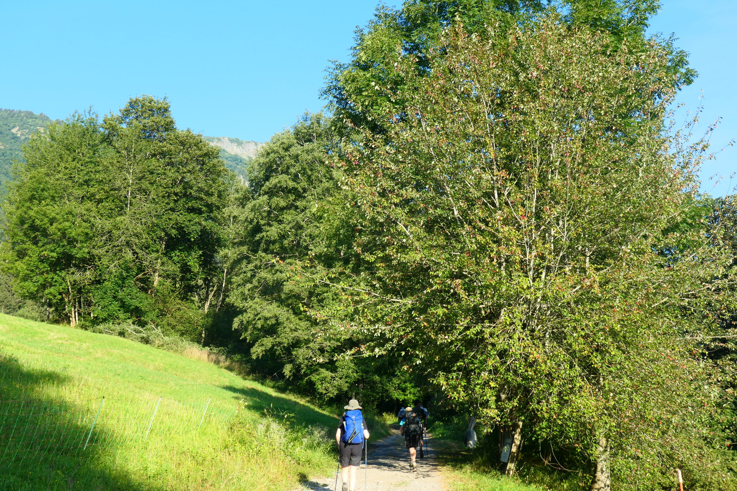
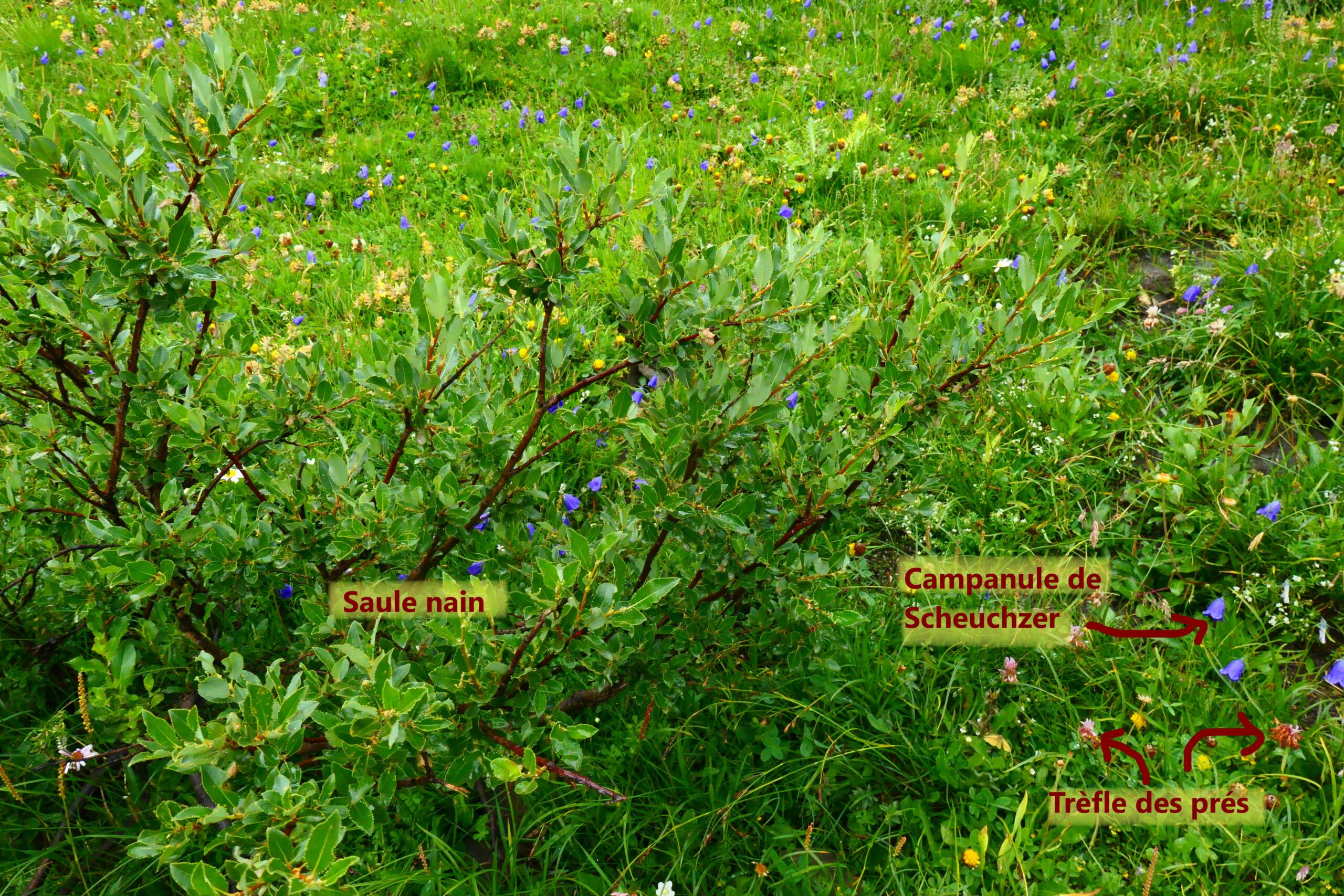
While climbing up towards the Bertone mountain cabin, take a look at the mountain flank in front of you. Amid the green spruces, you’ll notice a treeless zone where grey rocks are exposed. This isn’t the result of logging but rather a landslide that has stripped away the vegetation. The forest has grown on ancient glacial moraines, which now form the slopes of the Courmayeur Valley. The retreat of the glacier has destabilised these slopes, and the roots of the trees are not enough to keep them stable. During heavy rainfall, water seeps deep into the ground, increasing the weight of the rock formations and making it easier for them to slide towards the valley. This is an example of a rotational landslide, characterised by the concave, upward-curving rupture surface.
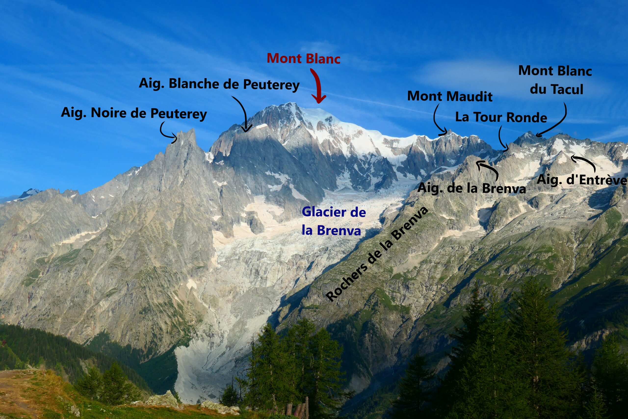
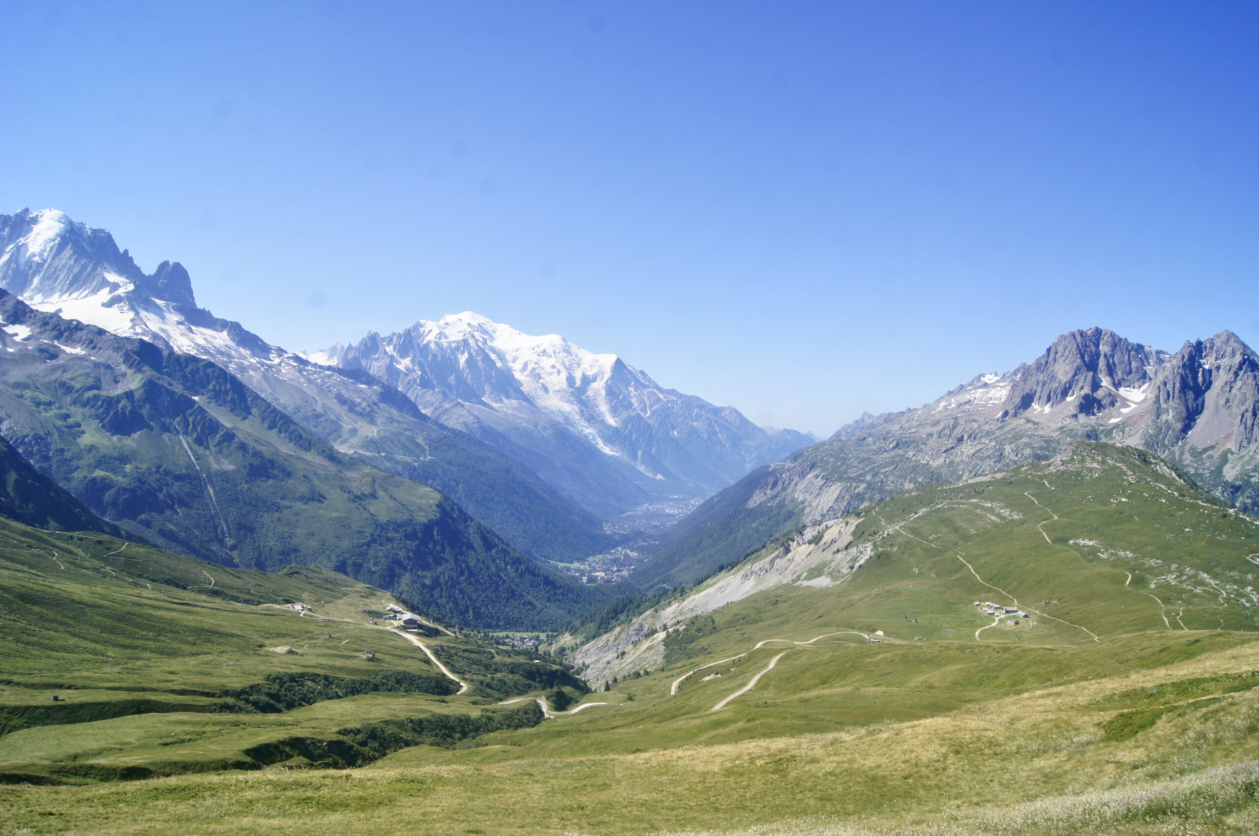
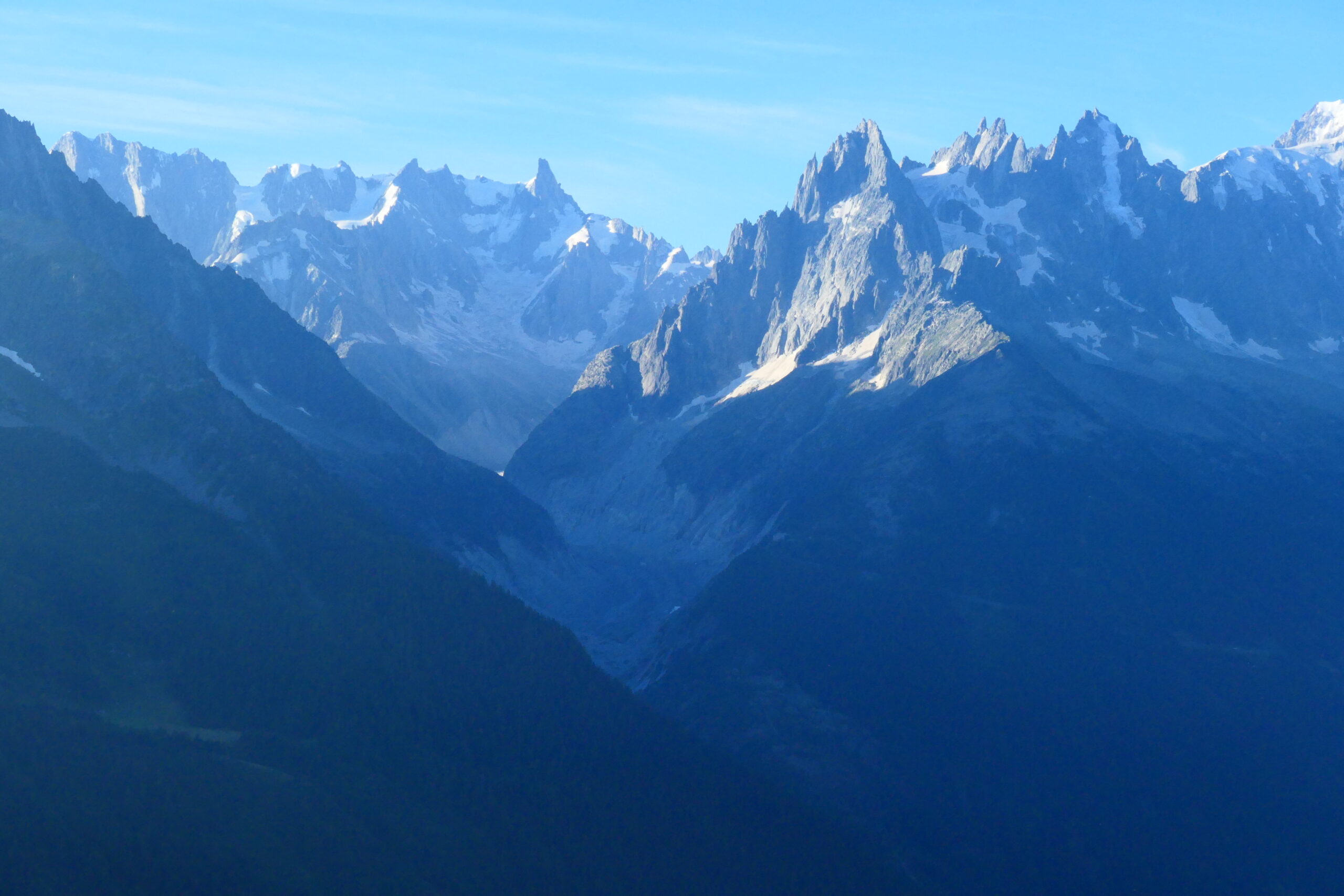
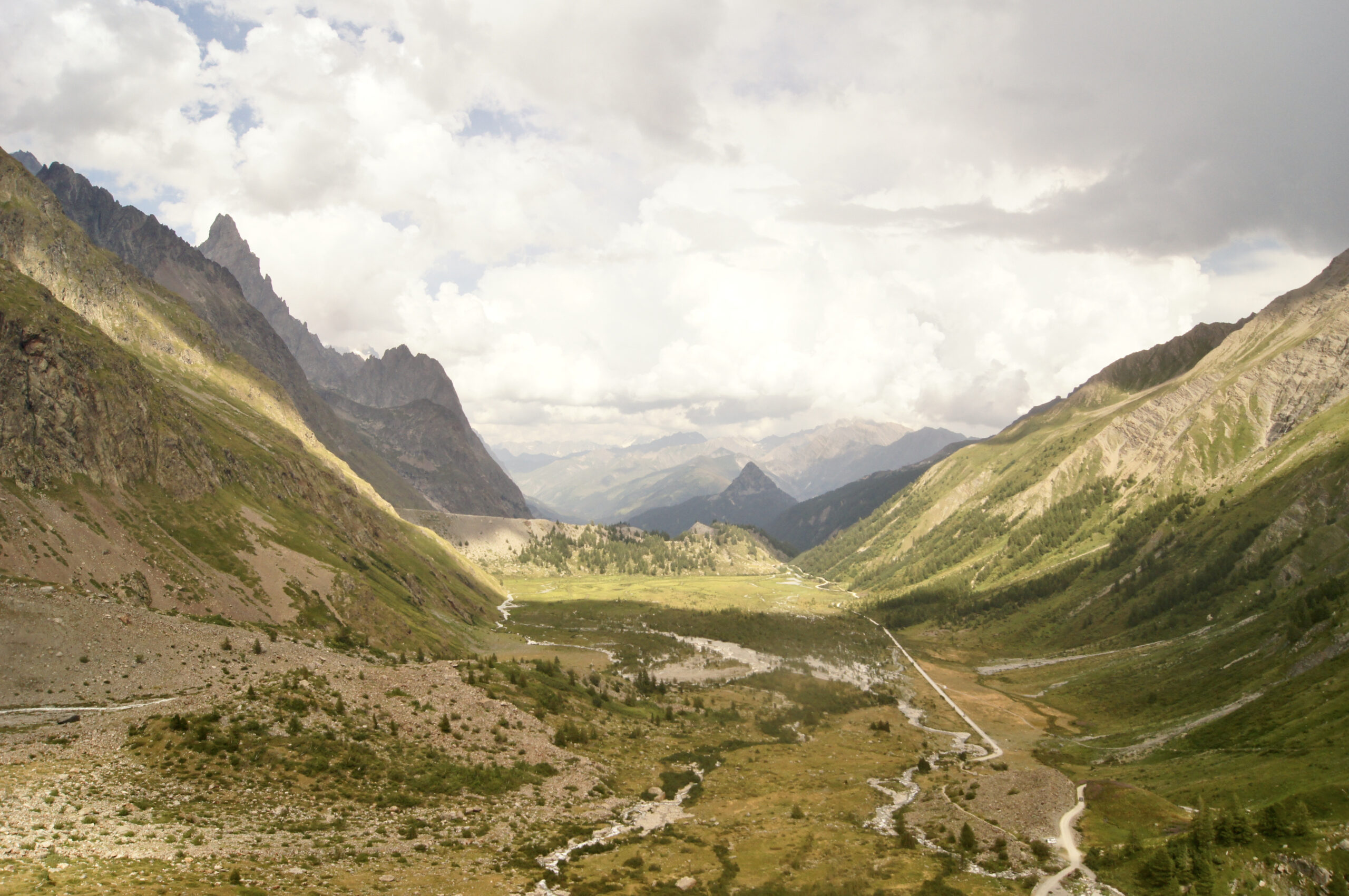
As we gain our first sweeping view of the hike, it’s the perfect moment to introduce the Mont Blanc Massif that we are about to circle. Geographically, the Mont Blanc Massif spans three countries: France, Italy, and Switzerland. Within this massif lies the highest peak in Western Europe, Mont Blanc itself, which rises to an impressive 4810 metres and stands slightly west of our current vantage point. Geologically, the Mont Blanc Massif belongs to the “crystalline external massifs” of the Alps. These formations are part of the foundational basement rock of the European tectonic plate and are composed primarily of ancient rocks like granite and gneiss. From our position at around 2000 metres, a natural question comes to mind: why is Mont Blanc so high? To answer this, we must travel back over 300 million years and trace Mont Blanc’s complex geological history. This journey through time helps us understand the ancient processes that formed the massif, giving rise to the remarkable rocks and glaciers we see today.
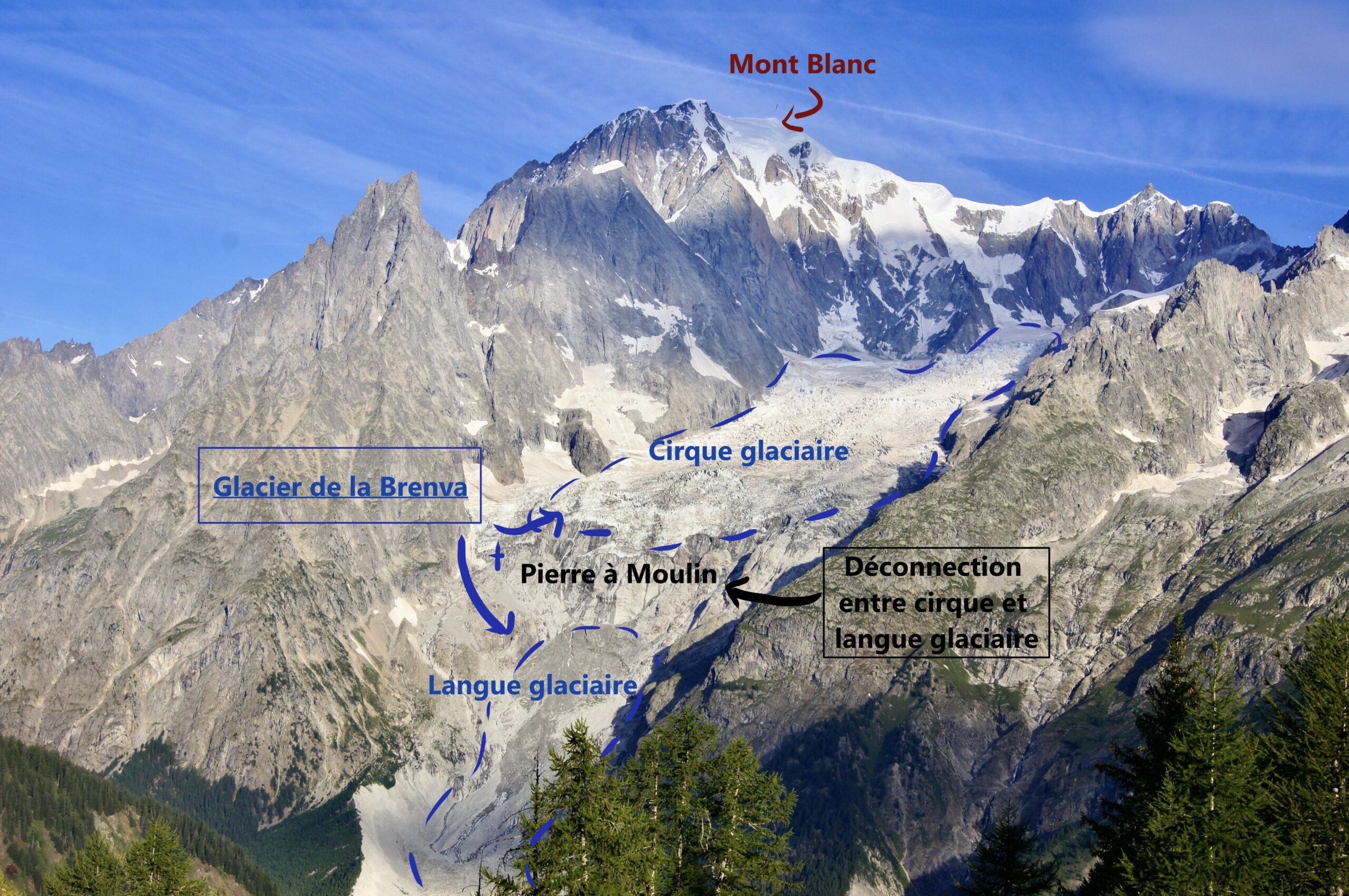
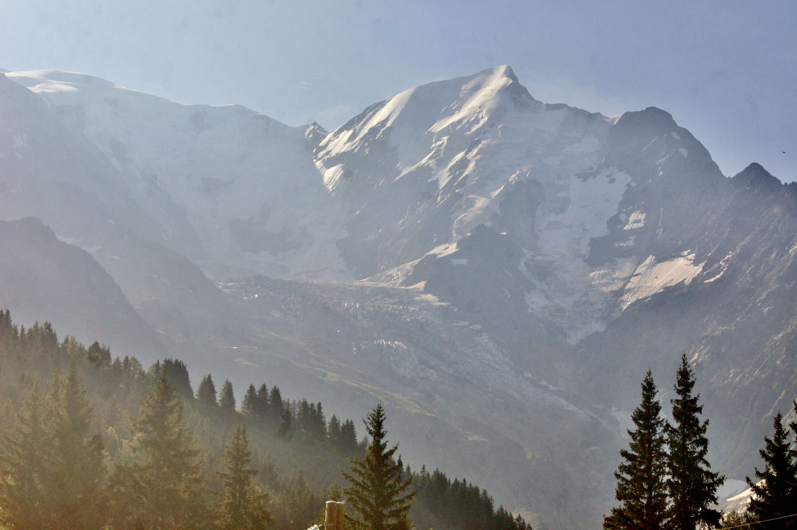
From our first sweeping viewpoint, we can pause for a closer look at the Brenva Glacier. This glacier begins at the base of Mont Blanc, nestled between two dramatic granite needles—the Noire and Blanche de Peuterey—south of Mont Blanc. Its formation is framed by surrounding peaks, including Mont Blanc itself, Mont Maudit, the Tour Ronde, and the Brenva Needle. Upstream, we can see the glacier’s original cirque, cradled by these peaks, and downstream lies the rocky-covered glacier tongue. The connection between the cirque and the tongue has progressively weakened since the end of the Little Ice Age, with the Pierre-à-Moulin constriction further limiting flow. Between 2000 and 2019, despite the protective rock covering insulating it, the glacier tongue shrank at an average rate of four metres per year. No longer replenished by the cirque, this tongue is now on a path towards disappearance.
Sources
- Antoine Rabatel, Etienne Ducasse, Victor Ramseyer et Romain Millan, « Évolution récente et à venir des glaciers du Val Veny (massif du Mont-Blanc, Italie) : apports de la télédétection satellite optique », Journal of Alpine Research | Revue de géographie alpine [En ligne], 111-2 | 2023, mis en ligne le 02 novembre 2023, consulté le 29 octobre 2024. URL : http://journals.openedition.org/rga/11575 ; DOI : https://doi.org/10.4000/rga.11575
- Massimo Riso, “I ghiacciai del monte Bianco (versante Italiano) 1818-2014”, Nimbus, Genova Numero 64, Mis en ligne en 2019, consulté en 2024, URL : http://www.nimbus.it/liguria/rlm64/GhiacciaiMonteBianco.html
- Wikipedia, “Glacier de la Brenva”, dernière modification le 30 septembre 2024, consulté en septembre 2024, URL : https://fr.wikipedia.org/wiki/Glacier_de_la_Brenva
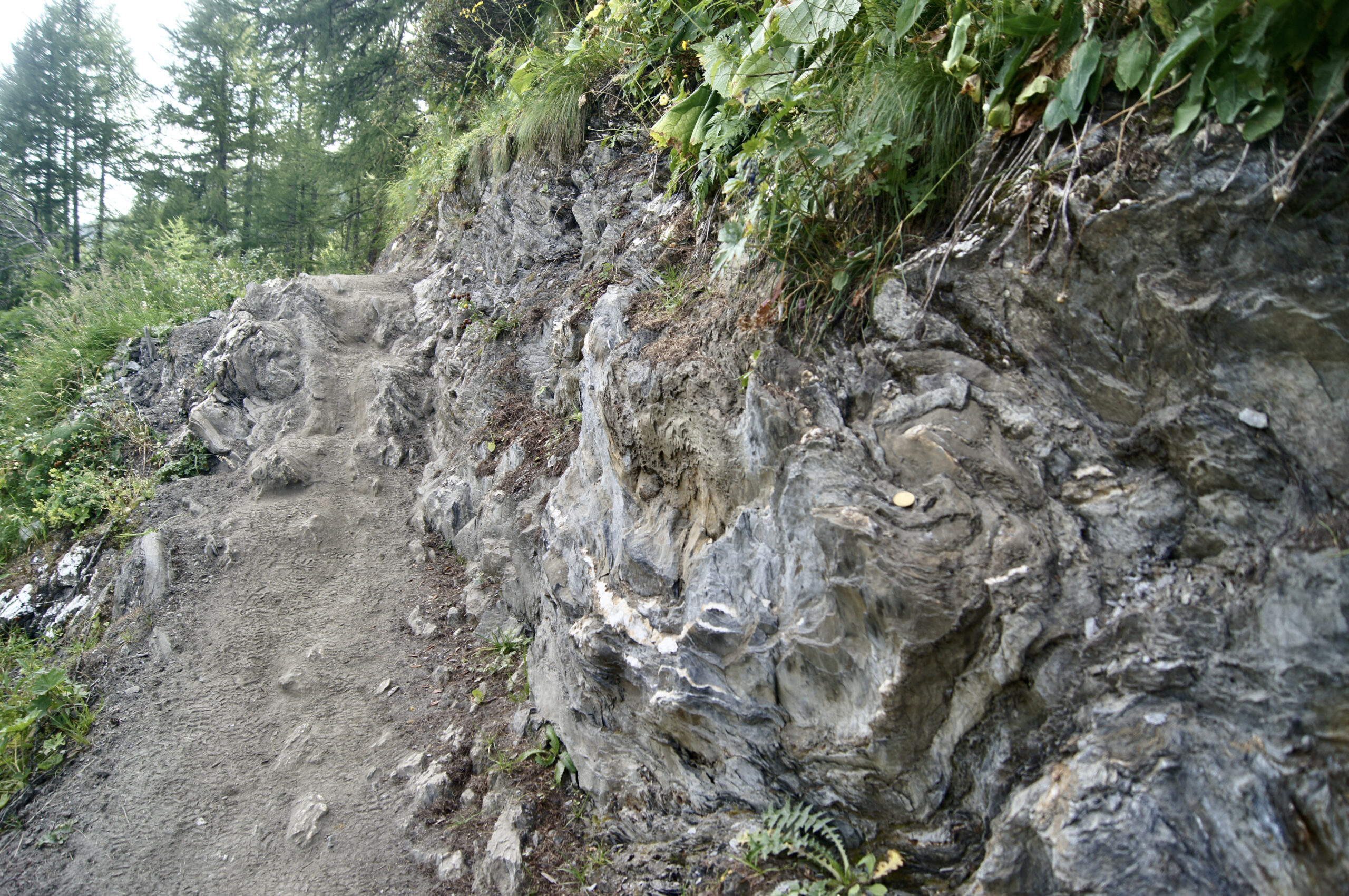
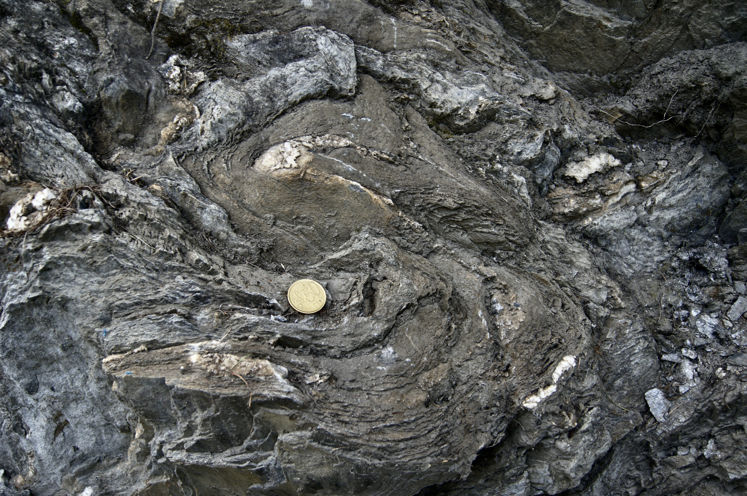
Look around and beneath your feet: the ground is dark, dusty, with scattered cobbles. The slopes are gentle, and the rocks along the path form a low wall—these are schists. These sedimentary rocks were deposited between 175 and 170 million years ago, during the Aalenian, at the bottom of the ancient Alpine Ocean (Tethys). About 130 million years ago, the African plate began pushing north, closing the ocean and raising these rocks to over 2000 meters. During the Alpine orogeny, the softer schists were deformed, folding and twisting as their originally horizontal layers became vertical.
From our vantage point along the path, we enjoy a clear view of the valley below. Two major geological formations emerge in the landscape: the crystalline peaks of the Mont Blanc massif’s basement rock, and, after a break in the slope, the softer, gentler topography of the sedimentary cover. Look for the grey-blue outcrops of Middle Jurassic rock, whose schistose layers appear to dip downward beneath Mont Blanc. Around 14 to 6 million years ago, the sedimentary cover of Mont Blanc—known as the Morcles Nappe—was thrust beneath the massif. In terms of relative movement, it means that Mont Blanc rose up as the Morcles Nappe was thrust beneath it. The break in the slope marks the trace of this reverse fault.
Sources
- A. Mercier, P.H. Leloup, G. Courrioux, S. Caritg, S. Lopez, P. Grandjean, S. Passot, A. Kalifi, “Large thrusting and late faulting shape the Aiguilles Rouges crystalline massif (Western Alps), structural implications”, Tectonophysics, Volume 847, 2023, 229691, ISSN 0040-1951, https://doi.org/10.1016/j.tecto.2022.229691
- Matthieu Petetin, “Structures géologiques, lecture géologique des paysages”, geologie-montblanc, consulté en 2024, URL : http://www.geologie-montblanc.fr/structures.htm
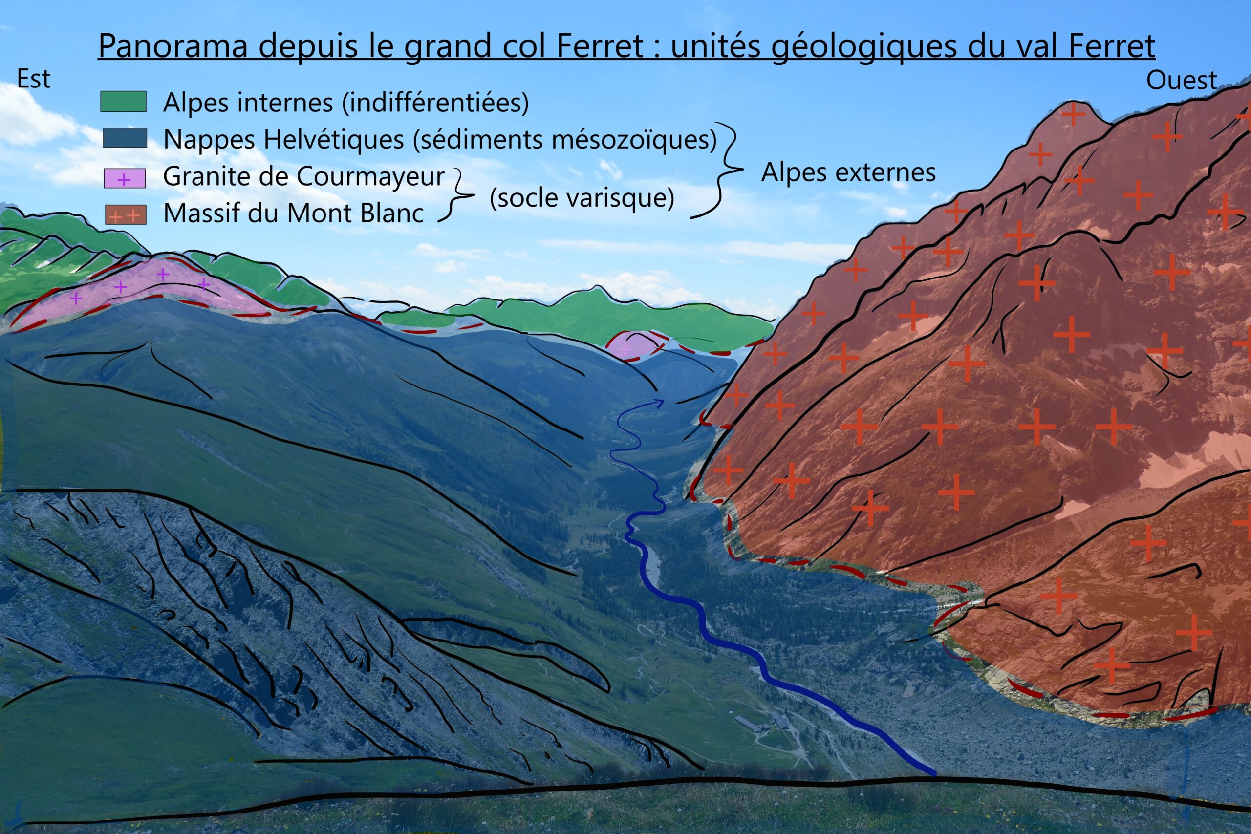
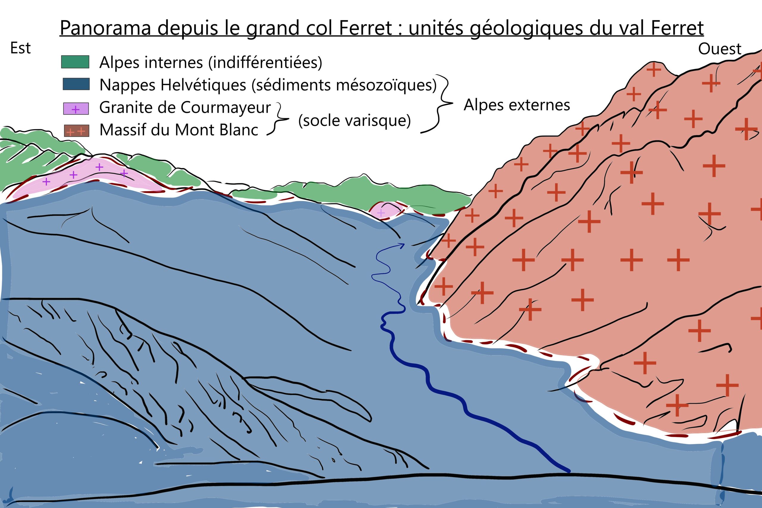
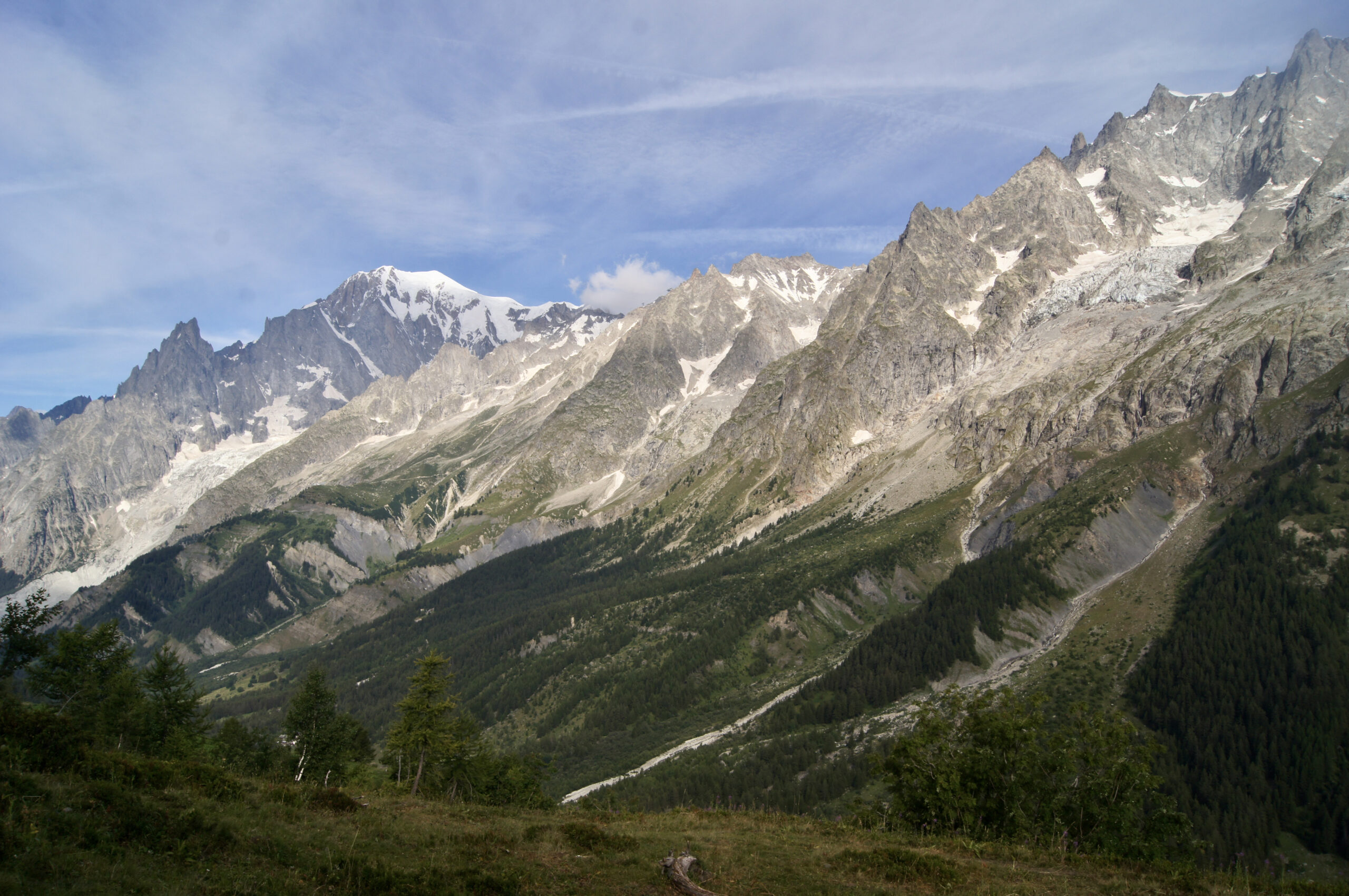
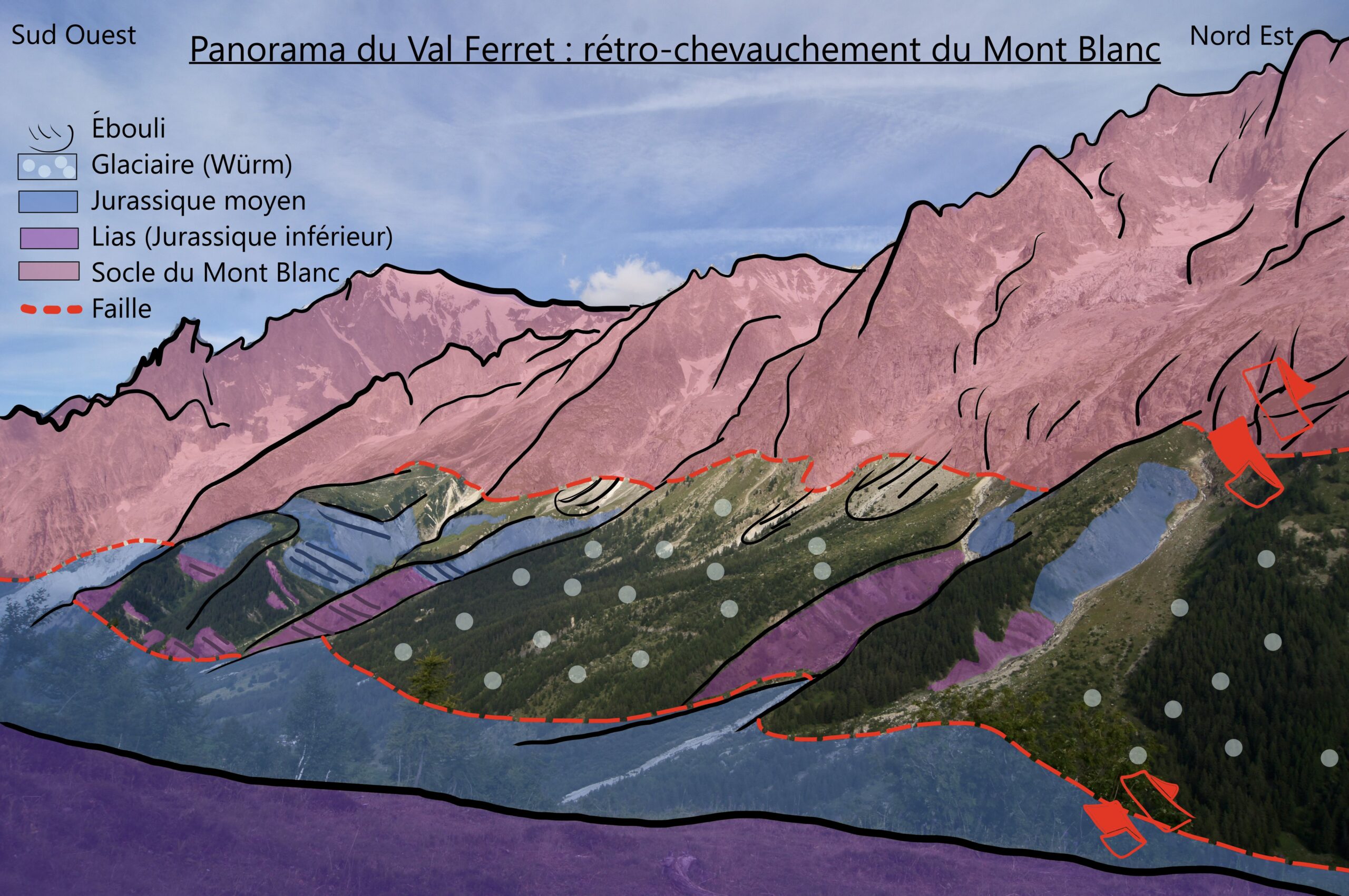
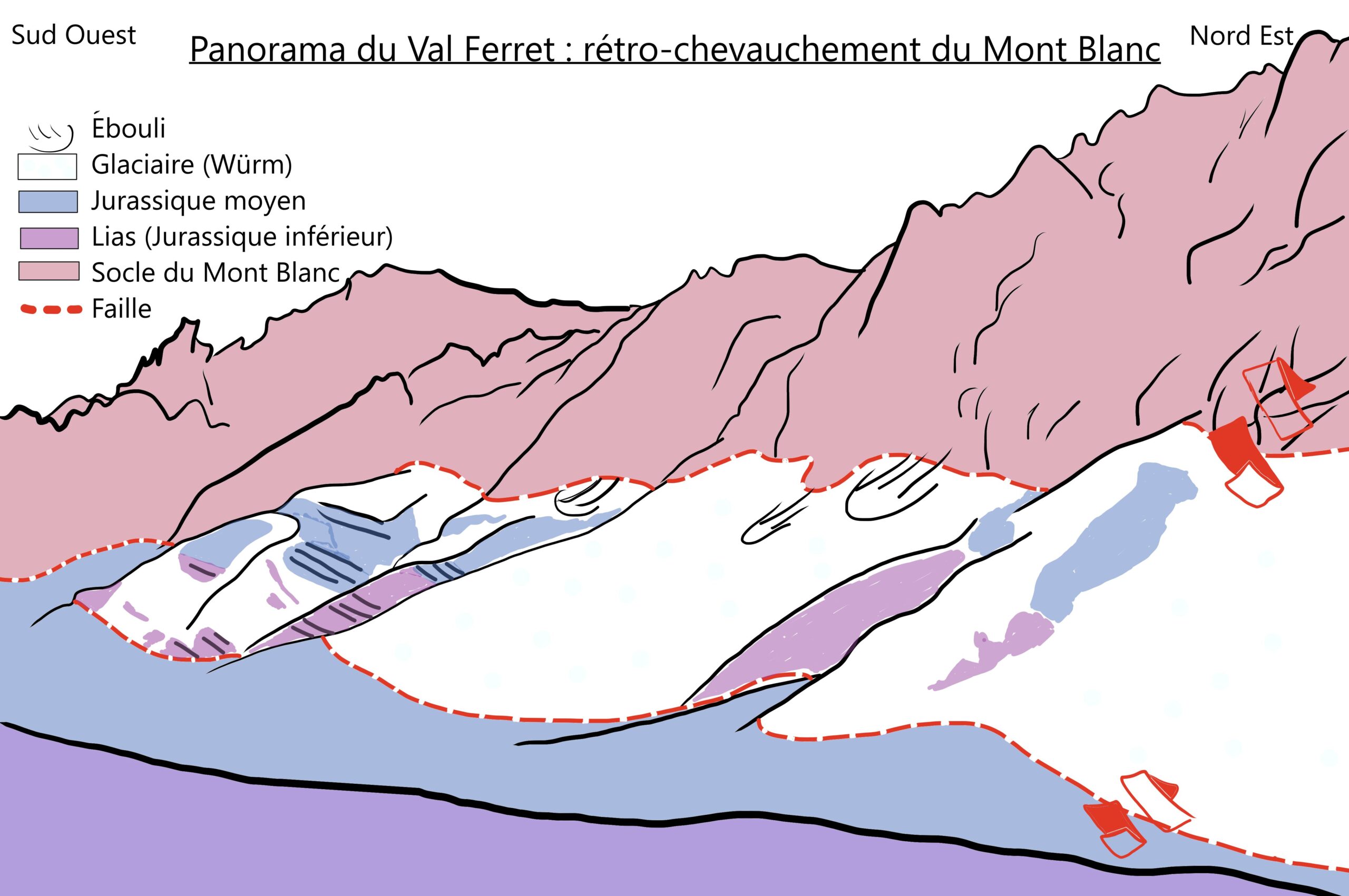
At the summit of Grand Col Ferret, you stand at the border between Italy and Switzerland. In the Italian Val Ferret below, distinct geological units are visible. To the east of Val Ferret lie the internal Alps, where deformation and metamorphism from Alpine formation are highly advanced. On the valley’s eastern flank, and within the valley itself, are the Helvetic nappes. These represent Mesozoic sedimentary layers displaced over great distances by thrusting from units farther east, including the Mont Blanc Massif. The Mont Blanc Massif consists of ancient rocks—mostly gneiss and granite—dating back over 300 million years to the Variscan orogeny. Both the Helvetic nappes and the Mont Blanc Massif belong to the external Alps, where Alpine deformation is less intense, and metamorphism is limited.
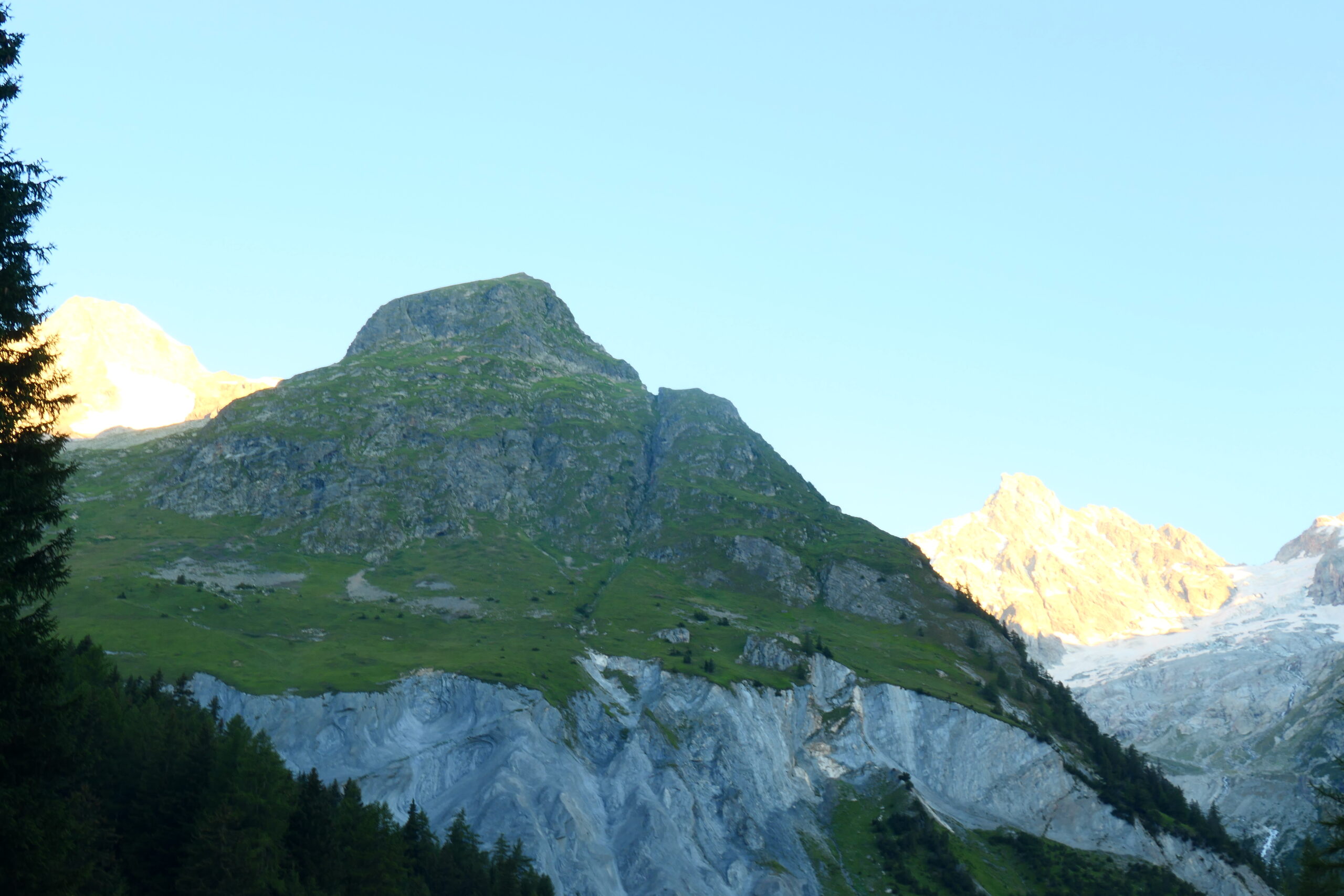
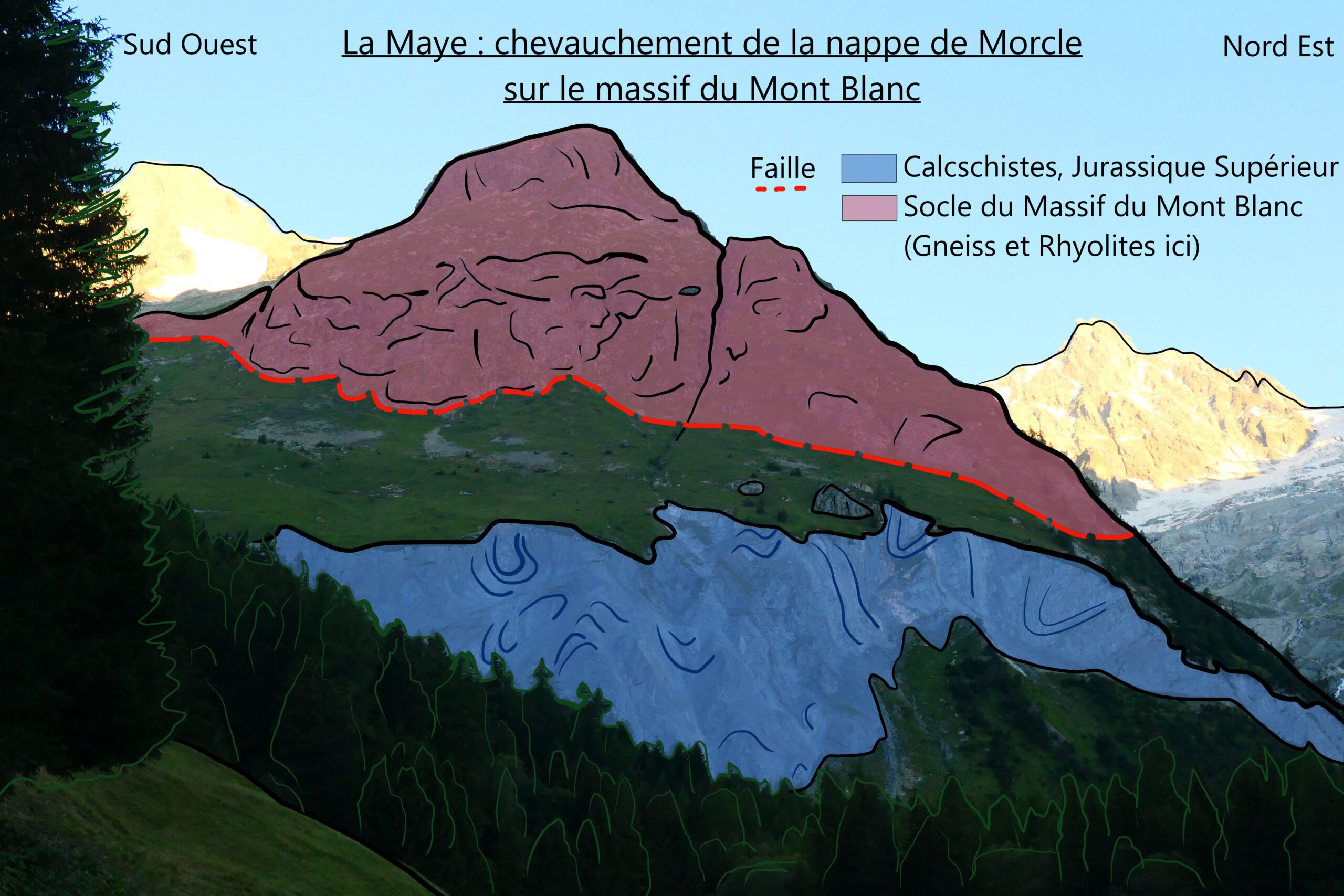
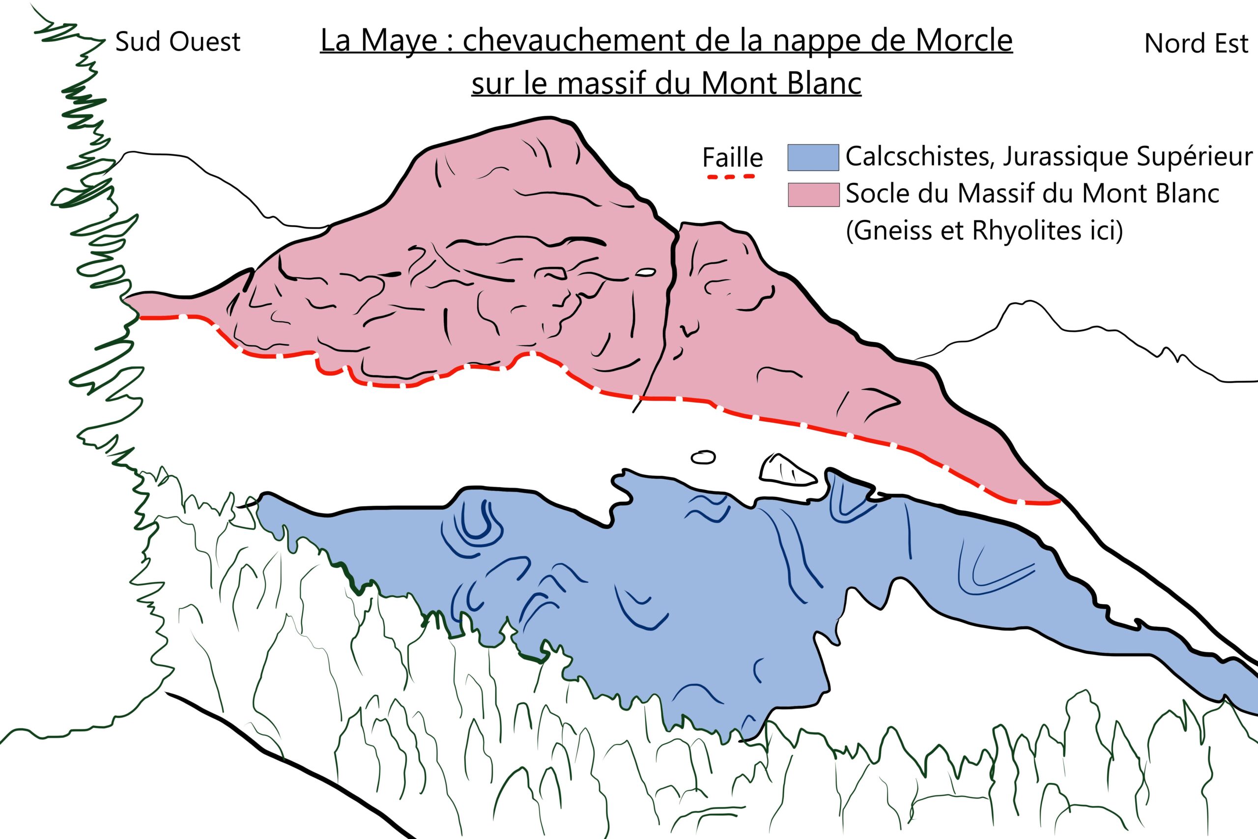
Standing before La Maye, we can immediately spot two distinct types of rock. At the summit, the dark brown rock shows no visible layering—this is rhyolite, a magmatic rock that forms part of Mont Blanc’s crystalline basement and dates back about 300 million years. Beneath it, we see a contrasting light-grey rock with orderly, nearly vertical layers. These are Middle Jurassic calc-schists (Malm, 150 million years old). The orientation of these schistose layers indicates that the sedimentary terrains have been stacked against the basement rock, similar to the Catogne which we will see later in the hike. This outcrop is a testament to the eastward movement of sedimentary nappes that, between 30 and 22 million years ago, were pushed over the Mont Blanc massif.
Sources
- Matthieu Petetin, “Structures géologiques, lecture géologique des paysages”, geologie-montblanc, consulté en 2024, URL : http://www.geologie-montblanc.fr/structures.htm
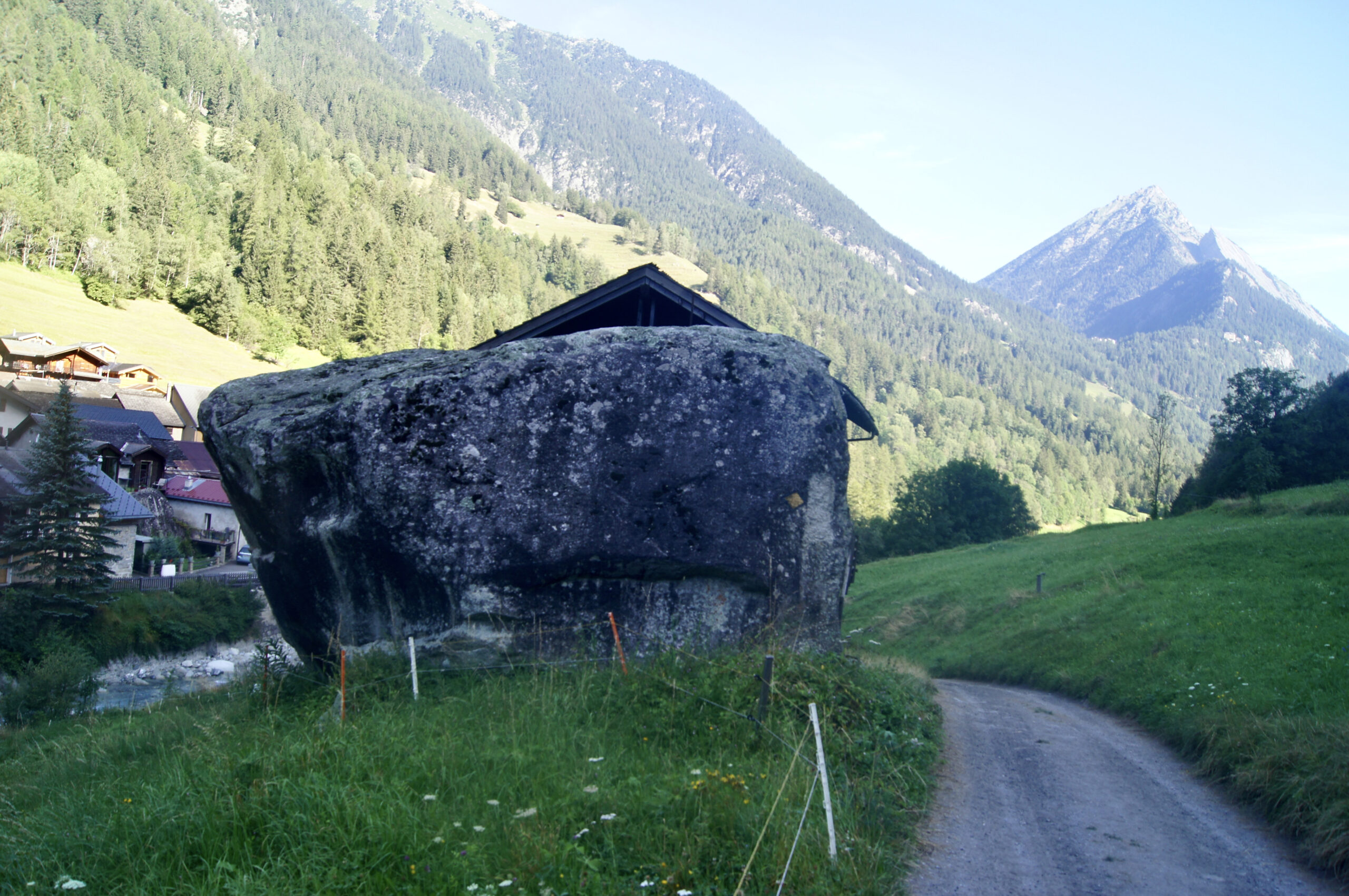
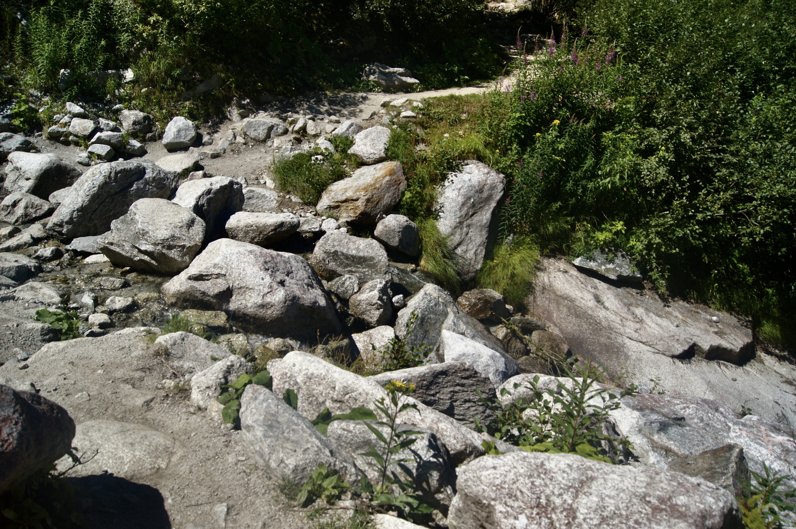
Have you noticed some of the large, isolated rock blocks? These are called erratic blocks, which are masses of rock that have been transported by glaciers over time. Glaciers alternate between advancing and retreating phases. As the glacier moves, it carries debris and rock blocks trapped within the ice. When the glacier retreats and melts, these rock masses are left behind, unless moved again by subsequent glacial activity. By analysing their composition, scientists can sometimes trace an erratic block back to a specific glacier, providing valuable information about the glacier’s past extent. These blocks are also useful to humans, sometimes being used in construction.
Sources
- Reynard, Emmanuel & Panizza, Mario. (2007). Geomorphosites: definition, assessment and mapping. Géomorphologie : relief, processus, environnement. 11. 10.4000/geomorphologie.337.
- Reynard, Emmanuel, Erratic boulders in Switzerland, a geological and cultural heritage Reynard Emmanuel EGU General Assembly Conference Abstracts 2015 https://ui.adsabs.harvard.edu/abs/2015EGUGA..17.4415R
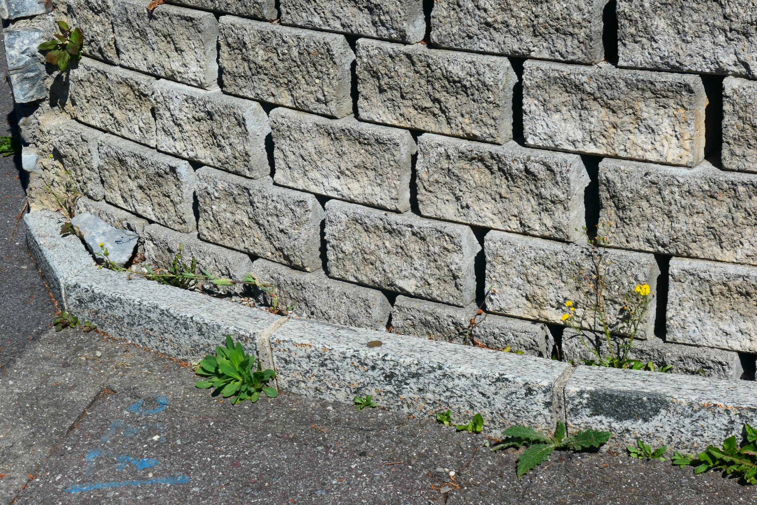
As we arrive in Champex, we begin to walk on the rocks that form the core of the Mont Blanc massif. These rocks, mainly gneisses and granites, have been used extensively in local construction. Gneisses are metamorphic rocks, created by mineral transformation under high pressure and temperature, but without reaching the point of melting. They are characterised by alternating bands of white minerals, such as feldspars and quartz, with darker layers of mica. When metamorphism reaches even higher temperatures, rocks can begin to partially melt. The products from this melting along with refractory residues crystallise in place to form migmatites, like those seen in the Champex-Lac parapets. In other cases, these melted materials gather to form larger bodies, crystallising later into granite plutons. Around 400 to 300 million years ago, a massive mountain range, comparable to the Himalayas, spanned across what is now Europe: the Variscan Mountain Belt. The immense pressure and heat generated by these mountains allowed for the formation of migmatites toward the end of the Variscan orogeny.
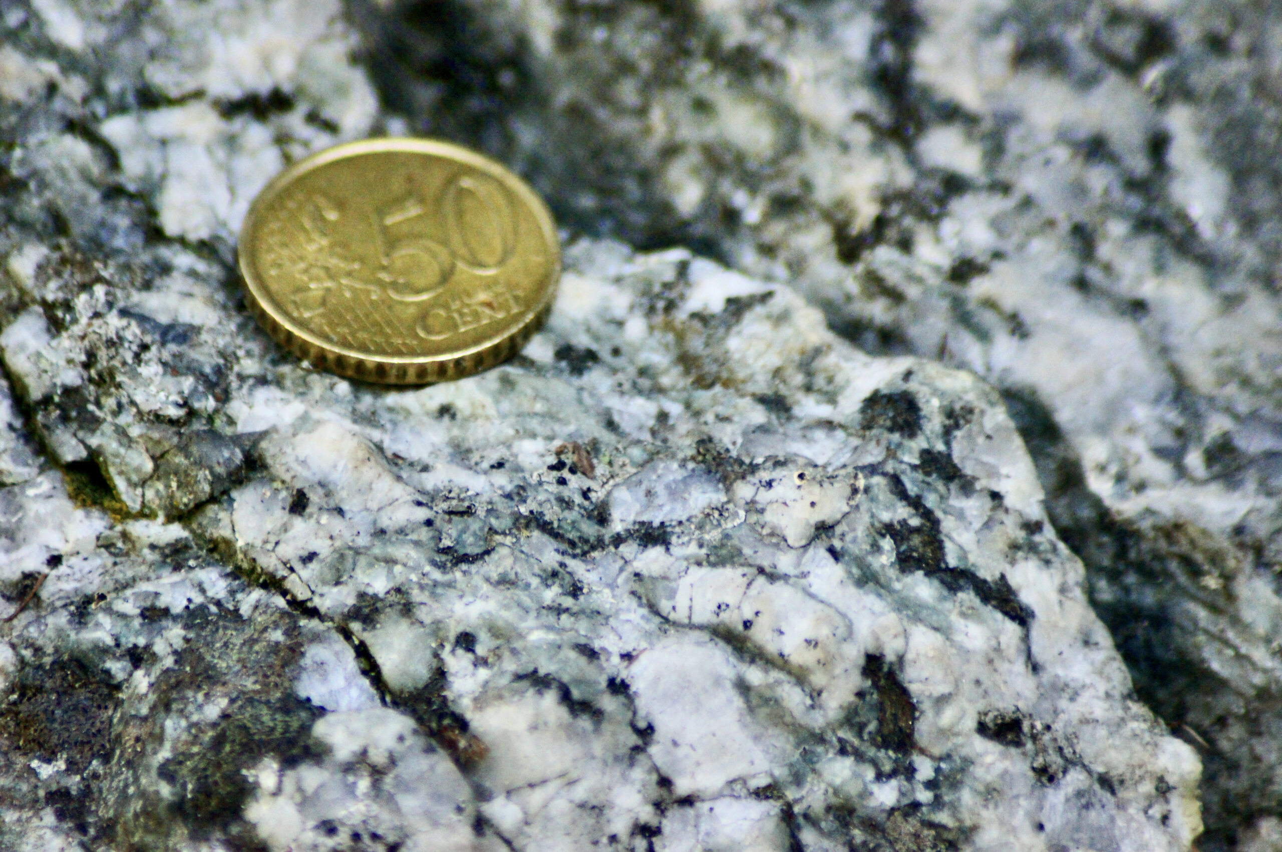
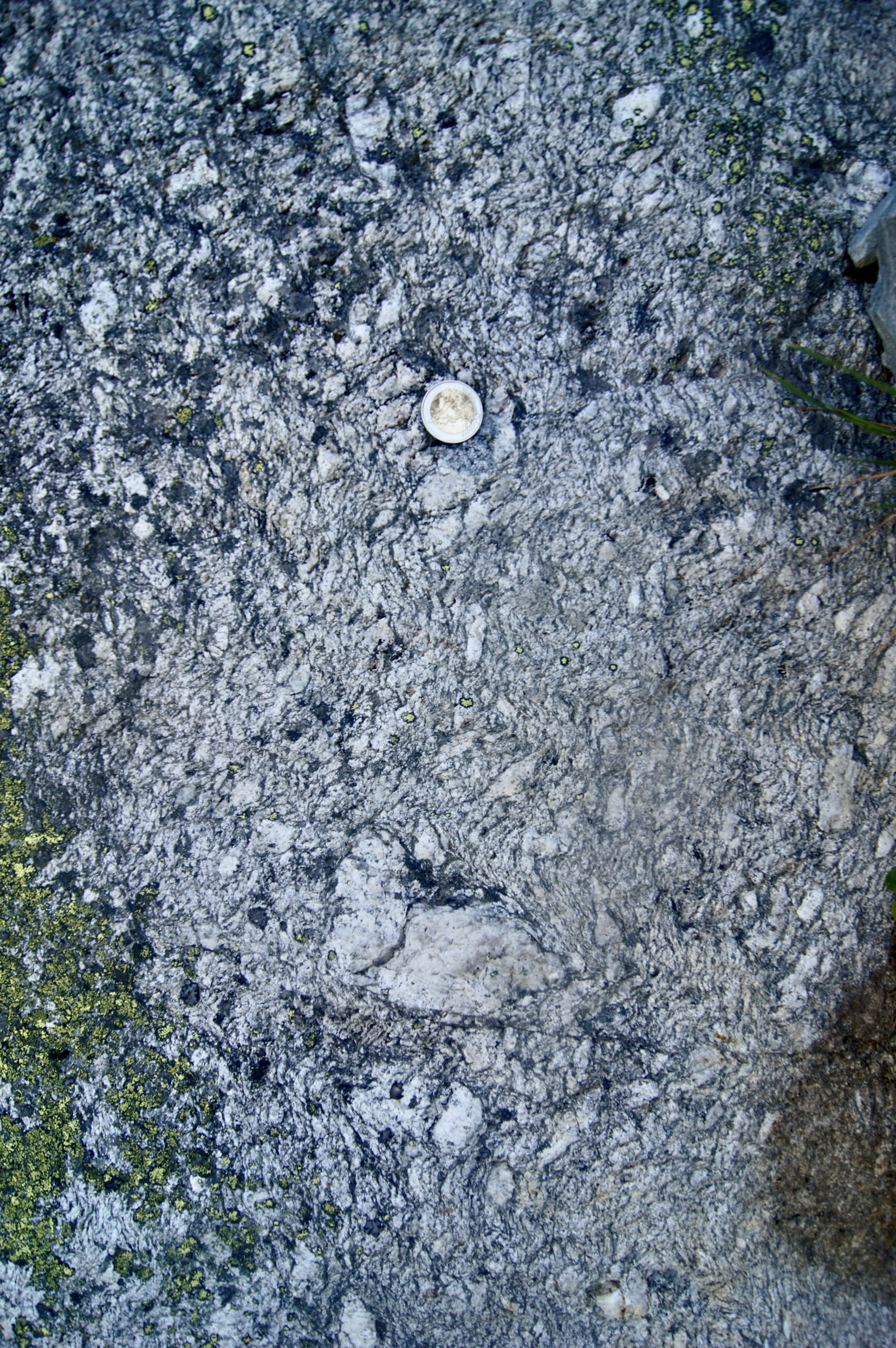
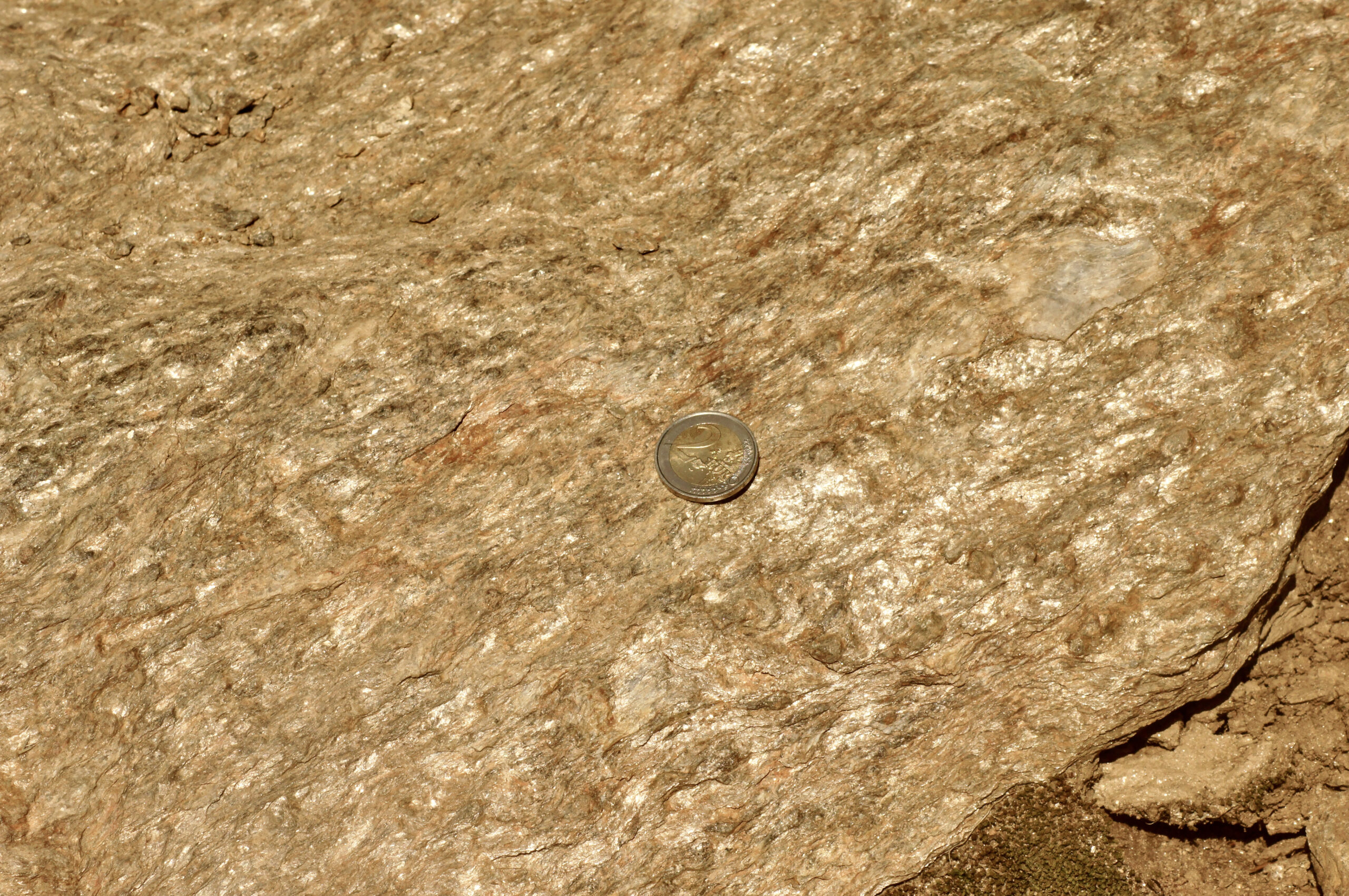
While climbing towards Bovine, you’ll notice black and white rocks with large grains, which are characteristic of Mont Blanc granite. These large grains correspond to the minerals that make up the granite. The milky-white crystals, sometimes with a pinkish tint and often rectangular in shape, are feldspars. The black minerals are biotite, a type of mica, while the shiny white minerals are another variety of mica called muscovite. Finally, the grey-transparent minerals are quartz. Over time, rocks undergo deformation due to tectonic stresses, which either pull or compress them. These stresses alter the rock’s environment, causing some minerals to become unstable and transform into more stable ones—this process is called metamorphism. Metamorphism is often linked with fluid circulation, and the greenish mineral you sometimes see in the granite is a product of the metamorphism of mica and feldspar, known as chlorite.
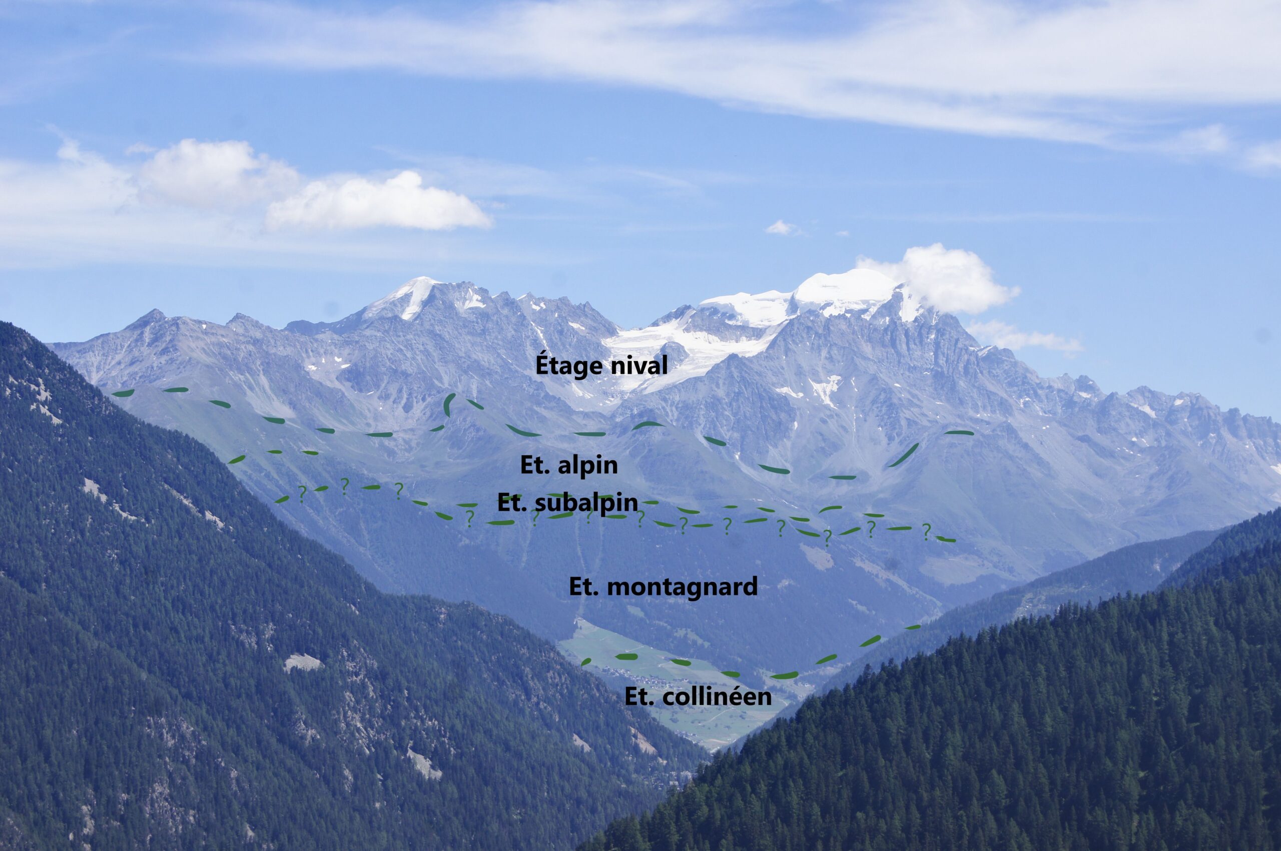
In mountain regions, temperature, humidity, snow cover, and sunlight vary with altitude. Temperature generally drops by about 0.6°C for every 100 metres climbed, while rainfall increases up to around 2500 metres before decreasing again. These variations create distinct vertical zones of vegetation, visible if we look east-southeast above Chandonne village. From the valley floor to the peaks, we can observe these zones: the collinean zone, marked by fields and broadleaf (feuillus) forests; the montane and subalpine zones, dominated by spruce forests around Mont Blanc; and, as the forest becomes sparser, the alpine zone, characterised by alpine meadows. Finally, at the highest elevations, the nival zone takes over, where rocks and snow dominate the landscape.
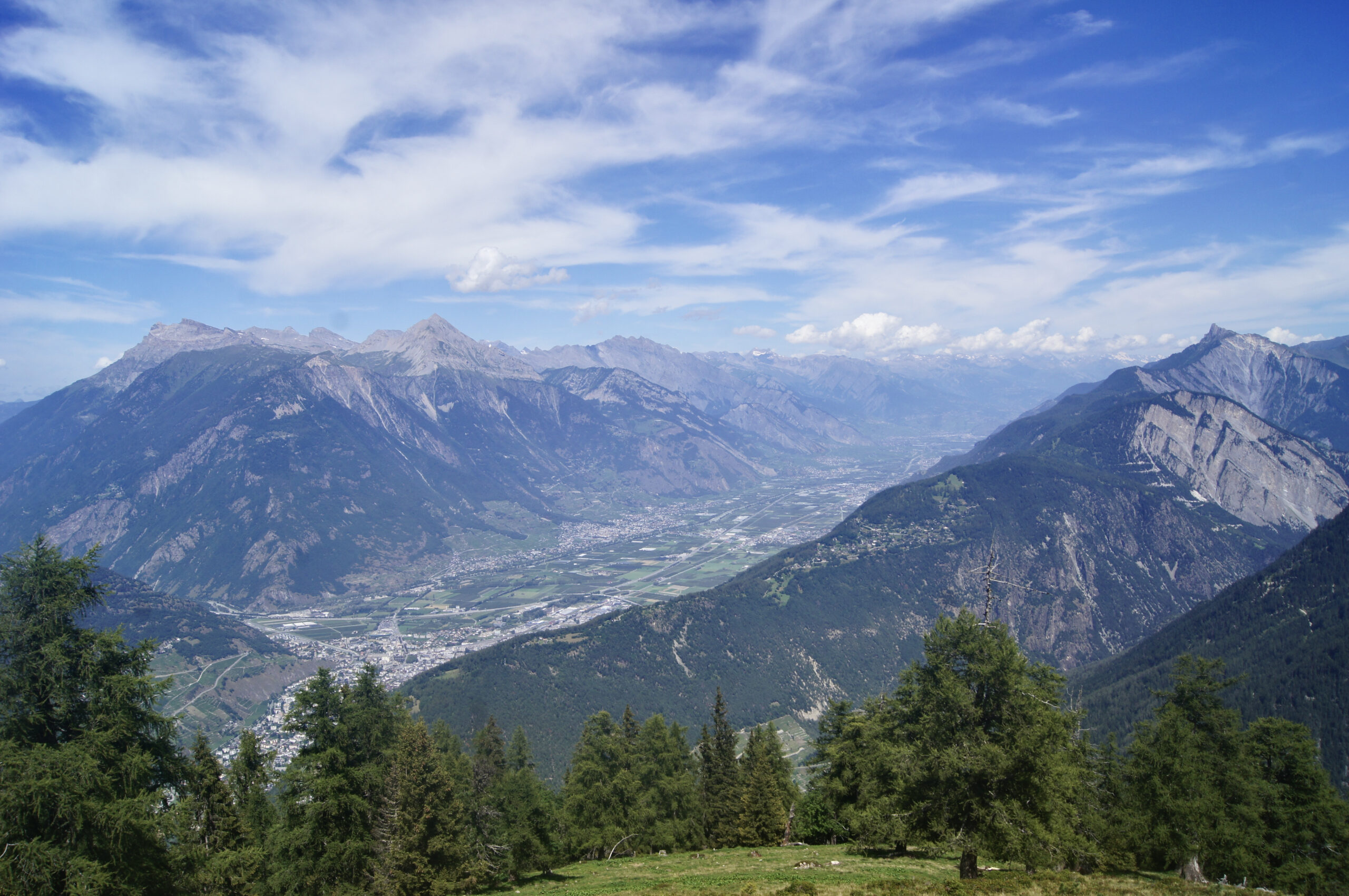
From the Bovine alpine pastures, looking north, you can see a vast agricultural valley with a patchwork of fields and urban areas. This is the Rhône Valley. The river bends sharply near Martigny before continuing northwest towards Lake Geneva. The valley’s flat floor and steep sides are hallmarks of a glacial valley, shaped by the repeated advances and retreats of Alpine glaciers during the last ice ages. Over time, the valley has undergone significant changes, including constructions around the Rhône since the 14th century and the transformation of marshlands and alluvial areas into farmland.
Sources
- Emmanuel REYNARD, Gilles A RNAUD-FASSETTA, Laetitia L AIGRE, Philippe SCHOENEICH. Le Rhône alpin vu sous l’angle de la géomorphologie: état des lieux. Extrait de Le Rhône: dynamique, histoire et société, textes réunis par Emmanuel REYNARD, Myriam EVÉQUOZ-DAYEN, Pierre DUBUIS, Sion, 2009 (Cahiers de Vallesia, 21), p. 75-102
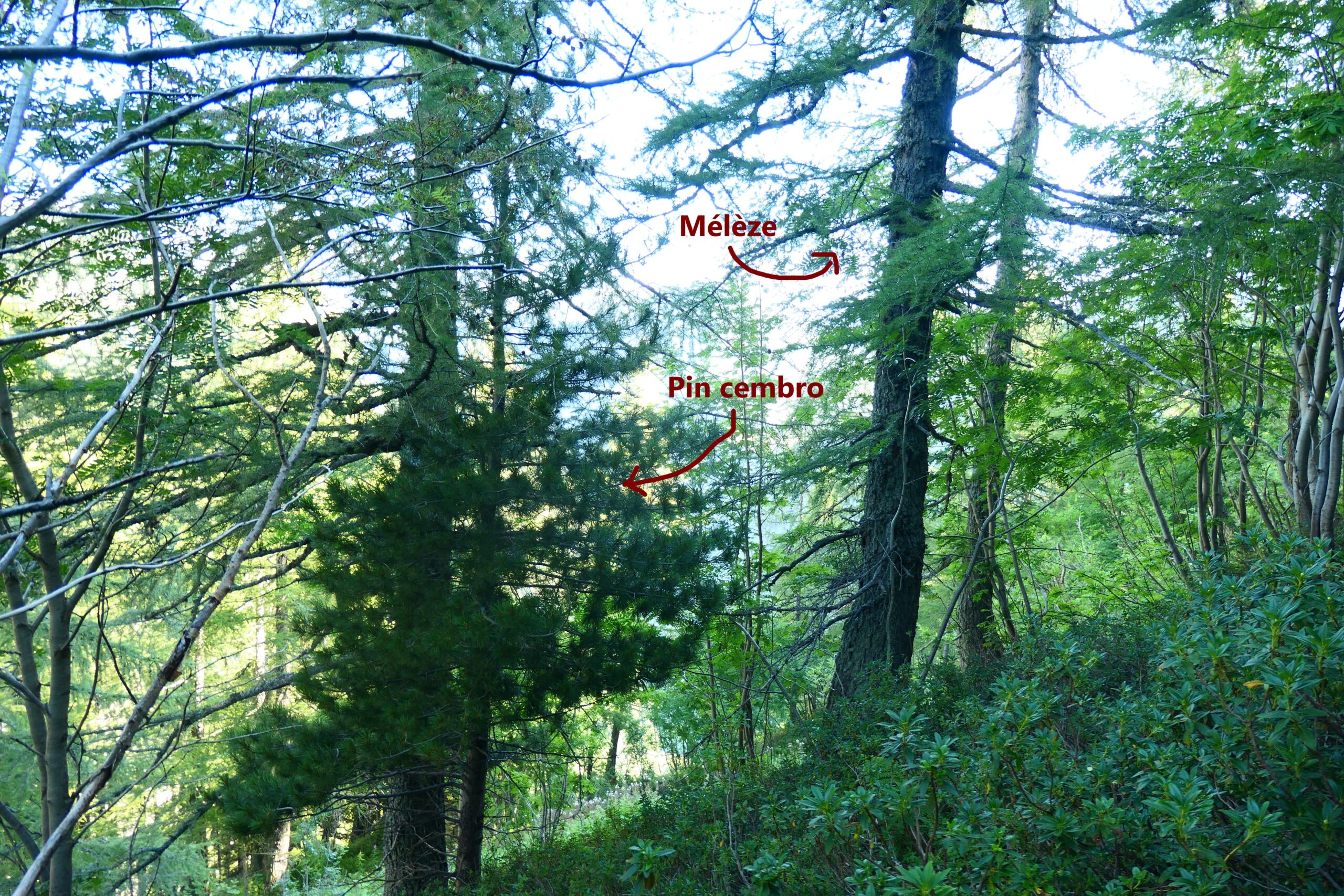
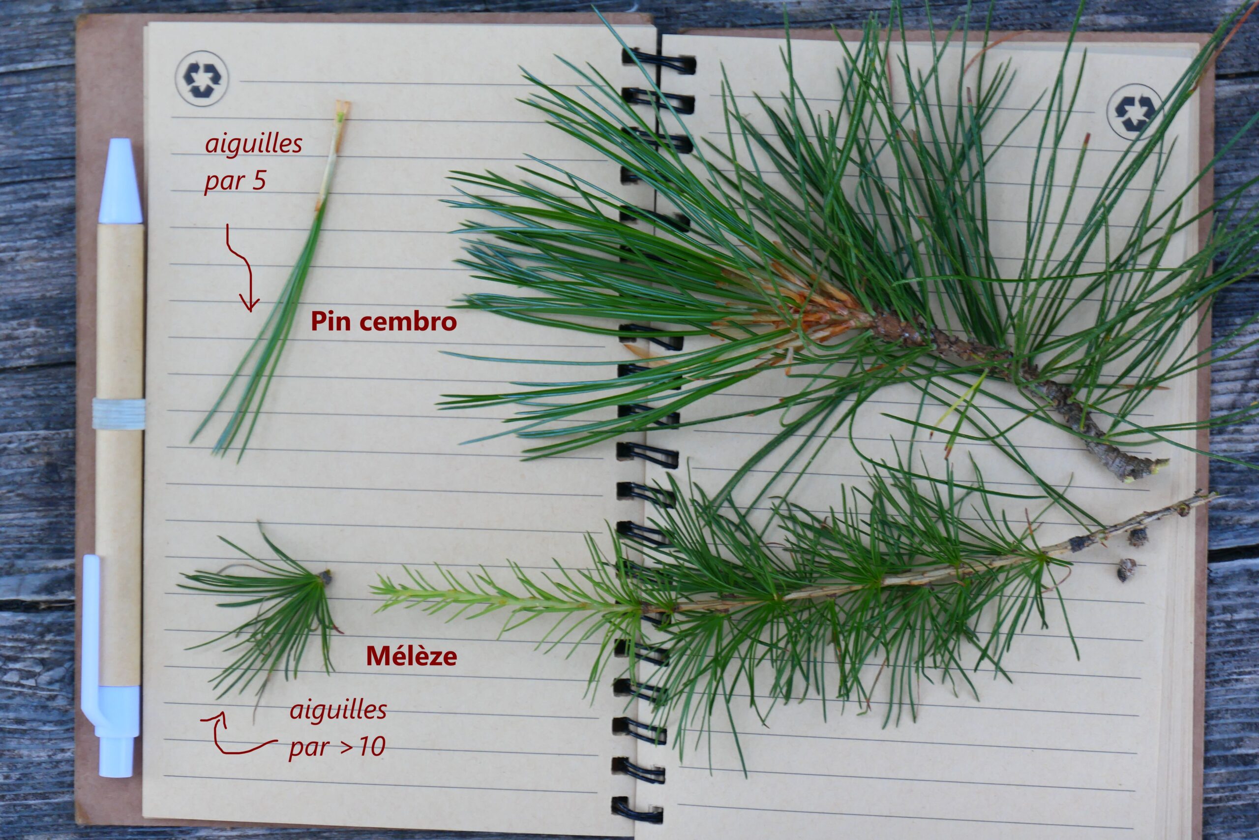
After climbing several metres through a dense spruce forest, you’ll start to notice new types of coniferous trees: larch and Arolla pine. The combination of these two species is characteristic of the subalpine zone, typically found between 1700 and 2200 metres, where the average temperature is around 2°C. You can easily distinguish these trees by their needles: while spruce needles grow individually along the branches, Arolla pine needles cluster in groups of five, and larch needles form bunches of more than ten. As for the fauna in this zone, you may hear the call of the spotted nutcracker, a bird largely responsible for the seed dispersal of Arolla pines. Its call is distinctive, sounding like a cross between a crow and an old-fashioned doorbell.
Sources
- Nathalie Petrel, “Le Mélèze d’Europe”, Office National des Forêts, consulté en septembre 2024, URL : https://www.onf.fr/vivre-la-foret/raconte-moi-la-foret/comprendre-la-foret/explorer-la-nature-en-foret/%2B/1c9e::le-meleze-deurope.html
- Paul Spanu, “Le Pin Cembro”, Office National des Forêts, consulté en septembre 2024, URL : https://www.onf.fr/vivre-la-foret/raconte-moi-la-foret/comprendre-la-foret/explorer-la-nature-en-foret/%2B/1d0f::le-pin-cembro.html
You are at the Col de Balme, which separates the Arve Valley (France) from the Trient Valley (Switzerland). Looking at the Arve Valley, you can see the Mont-Blanc massif to your left and the Aiguilles Rouges massif to your right. The rocks in these two massifs were formed deep underground during the Hercynian orogeny (400–250 million years ago). Erosion of the Hercynian mountains produced large quantities of sedimentary rock. Later, the opening of the Tethys Ocean led to the formation of submarine rocks such as limestones and dolomites. These, along with deep-seated rocks like granite and gneiss from Mont-Blanc and Aiguilles Rouges massifs, were uplifted during the Alpine orogeny.
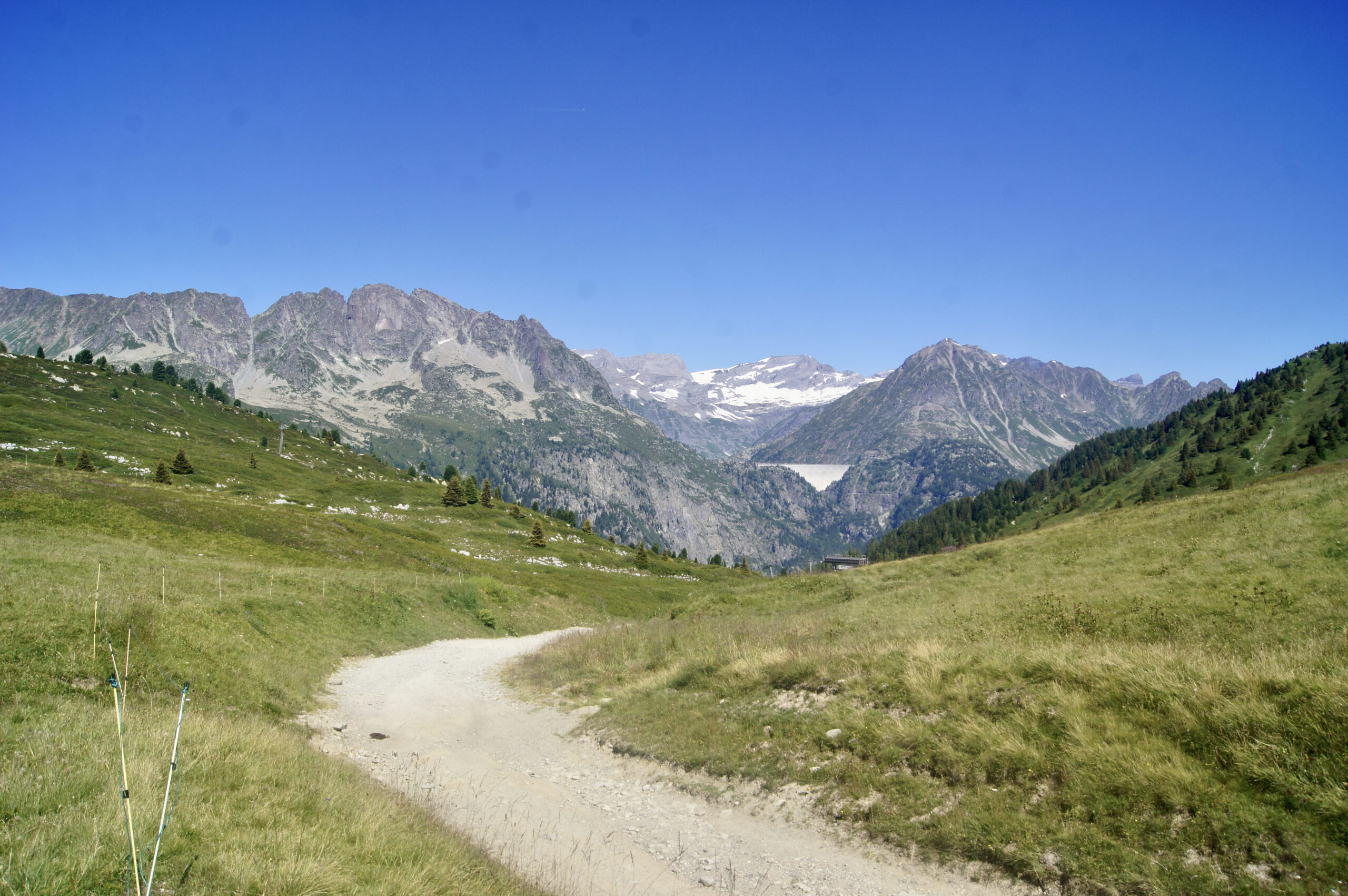
At Col des Posettes, looking towards the northwest, you can spot the Emosson Dam nestled within the gneisses of the Aiguilles Rouges massif. This impressive hydroelectric dam, standing 180 meters high, holds a reservoir with a capacity of 225 million cubic meters -enough to fill 90,000 Olympic-sized swimming pools. The water feeding the reservoir comes from subglacial streams of the Mont Blanc massif, such as the Argentière and Tour glaciers. These waters are transported to the dam via a network of underground tunnels crossing both France and Switzerland.
In the background of the panorama, you can see the Morcles Nappe, a thick layer of sedimentary rock that was transported from the Mont Blanc massif to the Aiguilles Rouges massif during the formation of the Alps through tectonic movements.
Sources
- Hervé Leloup et Serge Drouet, Vallée de Chamonix : massif du Mont Blanc, Les Guides Géologiques Omniscience, p76 et p 106-107, 2015
- Alpiq, “Emosson: Balades hydroélectriques”, mis en ligne en 2016, consulté en 2024, URL : https://www.alpiq.ch/fileadmin/user_upload/documents/generation_switzerland/alpiq_emosson_ausfluege_rund_um_die_wasserkraft_fr.pdf
- Jacques Wolff, “Aménagement hydroélectrique du barrage d’Emosson”, Bulletin de la Murithienne n°74, p50-53, 1957 URL : https://doc.rero.ch/record/24009/files/BCV_N_112_074_1957_050.pdf
- Jean Sesiano, “L’hydrogéologie: 10 ans de recherches dans la région d’Emosson et du Fer-à-Cheval”, Arve Léman Savoie nature, 2004, n° 12, p. 11–21
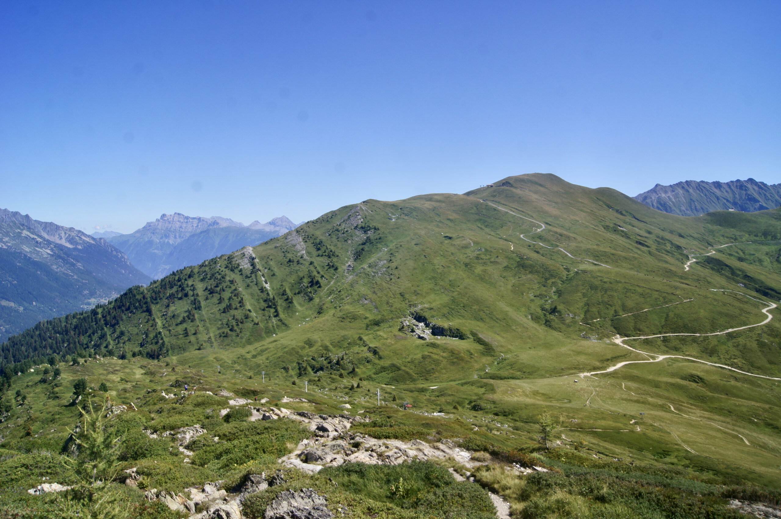
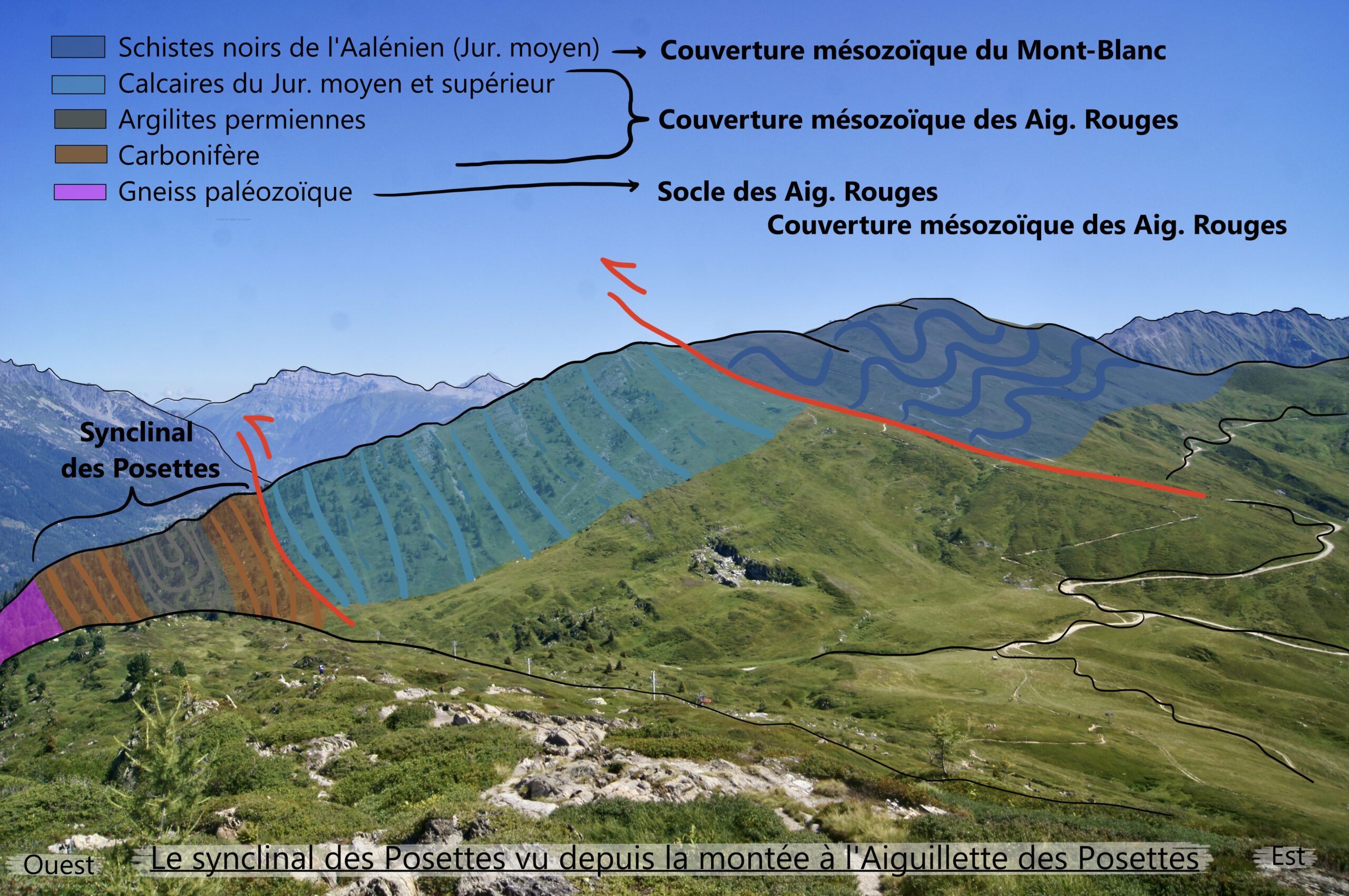
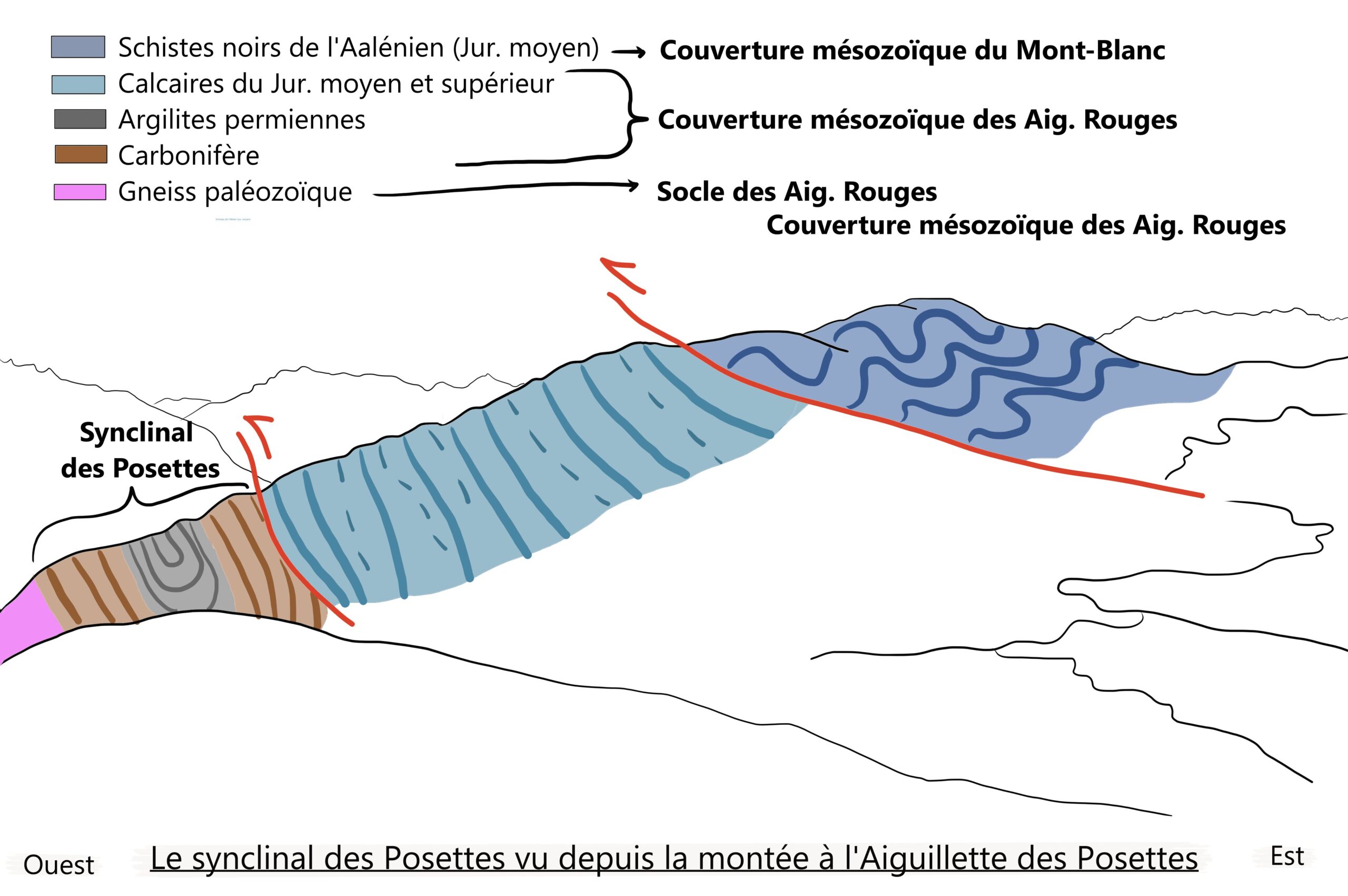
You’ve just crossed from the Mont Blanc massif to the Aiguilles Rouges massif. The suture between these two massifs lies directly to the north. From the col, we are walking on rocks from the Middle Jurassic period, with layers of Upper Jurassic calc-schists beneath them. This unusual arrangement—older layers above younger ones—indicates a thrust where the Mont Blanc cover has overridden the Aiguilles Rouges cover. Looking more closely at the Aiguilles Rouges cover, we see that Permian layers are enclosed within Carboniferous layers. This formation represents a very tight syncline, created by intense compression that brought the Mont Blanc massif closer to the Aiguilles Rouges.
Sources
- Hervé Leloup et Serge Drouet, Vallée de Chamonix : massif du Mont Blanc, Les Guides Géologiques Omniscience, p80, 2015
- Antoine Mercier, “Géologie 3D du du synclinorium de Chamonix, Implications sur les rapports entre les massifs cristallins externes et les chaînes subalpines”, mémoire de master, 2019, URL : https://rgf.brgm.fr/sites/default/files/upload/documents/production-scientifique/Masters/rgf_amialps2018_ma4_memoire_mercier.pdf
Near the summit of the Aiguillette des Posettes, at the arrival point of the teleski, you can observe clays tinted in shades of green and purple, known as versicoloured clays. Clays are sedimentary rocks formed by the stacking of layers of aluminium and silicon, and they can contain other elements, such as iron. The colour of these clays is influenced by the oxidation state of the iron present: a higher proportion of Fe²⁺ relative to Fe³⁺ will produce greenish tones, while an excess of Fe³⁺ tends to create purplish hues.
Sources
- Hervé Leloup et Serge Drouet, Vallée de Chamonix : massif du Mont Blanc, Les Guides Géologiques Omniscience, 2015
From Aiguillette des Posettes, you can admire the Aiguilles Rouges Massif, where the Remuaz Fault cuts through. This fault separates the Vallorcine granite from the crystalline massif of Aiguilles Rouges along a near-vertical plane, oriented southeast. The fault plane acts as a zone of weakness, allowing movement between these two blocks (imagine cutting butter in half—when compressed, it moves along the cut). It is likely that the significant earthquake of April 29, 1905, which caused extensive damage in Argentière and had an estimated magnitude between 5.1 and 5.7, occurred along this fault. Today, the Remuaz Fault remains active and is monitored by ISTerre (University of Grenoble Alpes), a research laboratory studying the micro-seismic activity (small earthquakes) along the fault. Their work aims to better understand local tectonics and help mitigate seismic risks in the Chamonix Valley.
Sources
- Michel Cara, M., Van der Woerd, J., Alasset, PJ. et al. “The 1905 Chamonix earthquakes: active tectonics in the Mont Blanc and Aiguilles Rouges massifs”, Swiss J Geosci 110, 631–651 (2017). https://doi.org/10.1007/s00015-017-0262-7
- Riccardo Vassallo, “Remuaz”, International Federation of Digital Seismograph Networks, 2024, https://doi.org/10.7914/ts1a-7g40, URL : https://www.fdsn.org/networks/detail/X4_2024/
- Hervé Leloup et Serge Drouet, Vallée de Chamonix : massif du Mont Blanc, Les Guides Géologiques Omniscience, p214-225, 2015
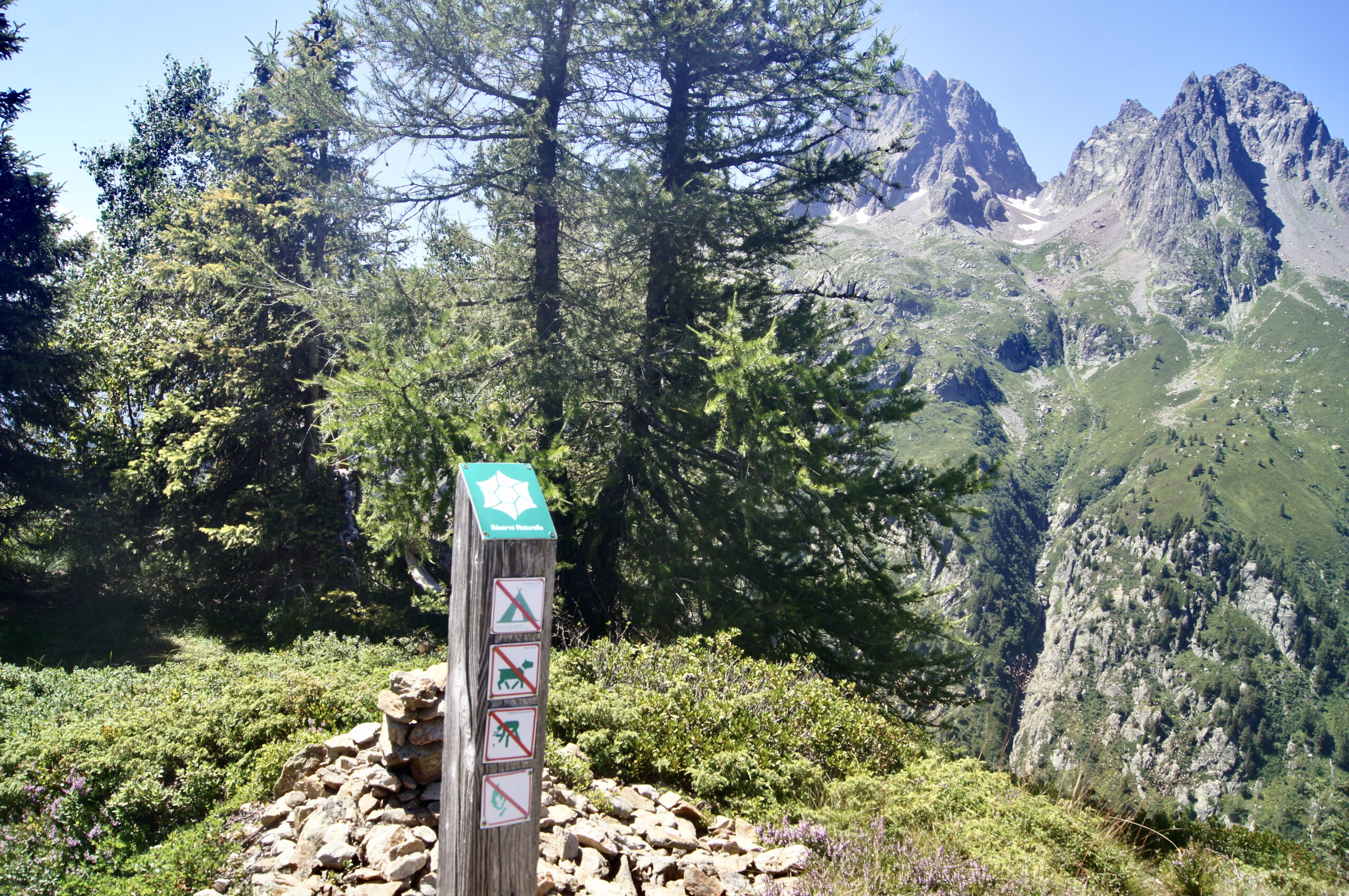
As you descend from Aiguillette des Posettes towards the village of Tré-le-Champ, you enter the Aiguilles Rouges Nature Reserve. Established in 1974, it covers 2 278 hectares of the Aiguilles Rouges massif. The reserve extends from the mountain level to the nival level, ranging from 1 200 m to 2 965 m at the Aiguille du Belvédère. To preserve these sensitive natural areas and promote sustainable tourism in the valley, we must all work together to protect them. Please do not pick flowers, and avoid camping outside designated areas. Dogs disturb the local flora and fauna and are therefore prohibited. Do not leave litter behind, and avoid lighting fires. The full regulations can be found here.
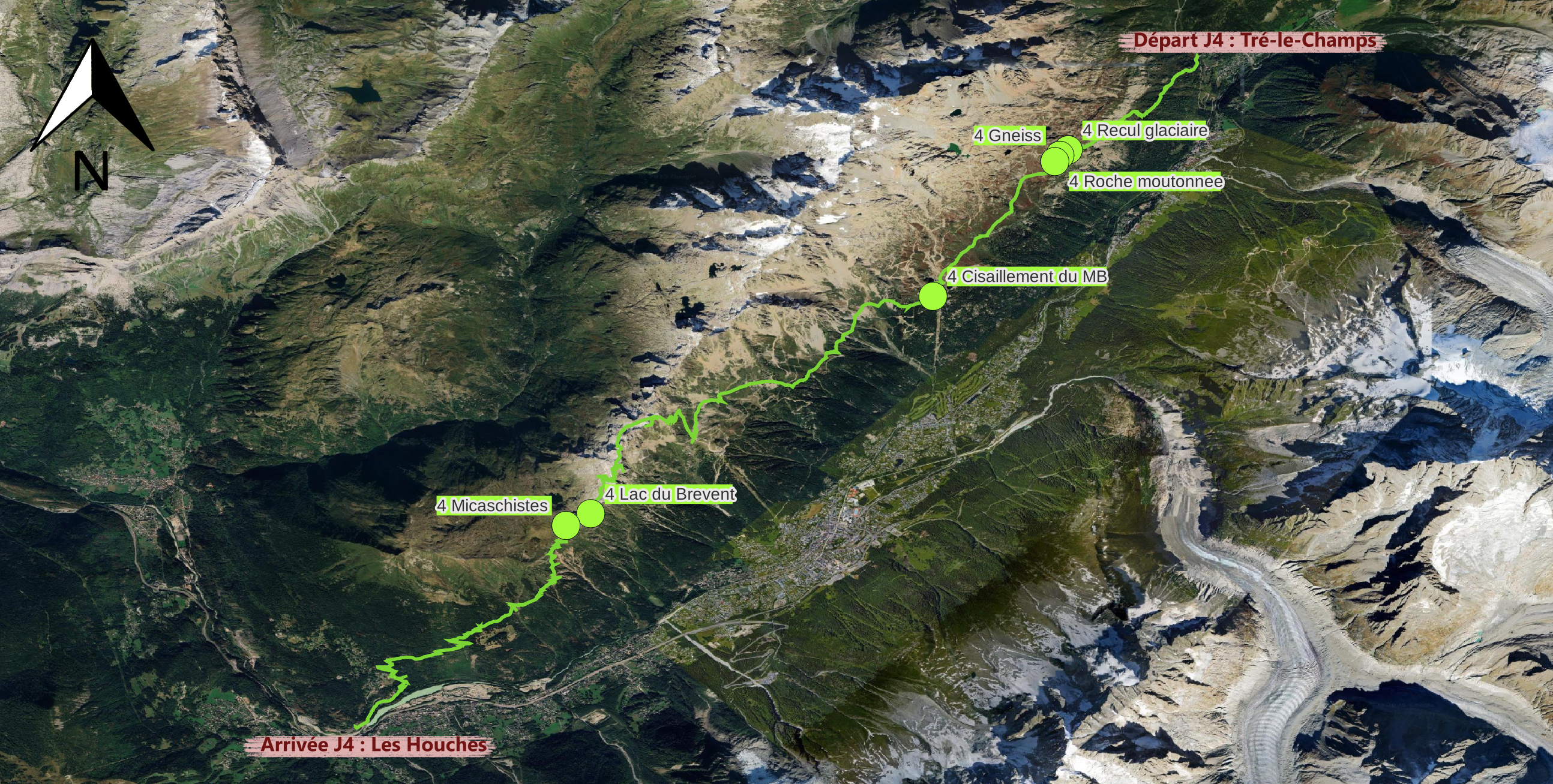
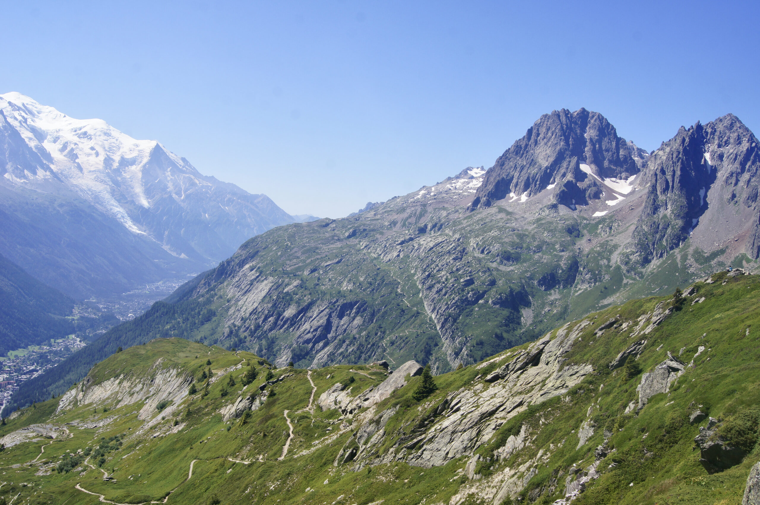
After completing your challenging climb, take a well-deserved break and marvel at the Mer de Glace glacier. Nestled between Les Drus and the Chamonix Aiguilles, the glacier winds through a broad, flat valley—carved by the glacier itself over time. Named by two British explorers, the Mer de Glace has been one of the most iconic tourist attractions in the Chamonix Valley since the 19th century. Its size has fluctuated greatly over time due to climatic variations. In the 17th century, the glacier extended all the way to the hamlet of Les Bois, causing fear among local residents due to the risk of glacial flooding. Today, however, the glacier has dramatically receded, largely due to the end of the Little Ice Age and ongoing climate change. It is now much smaller in both thickness and spatial extent. To catch a glimpse of the glacier, you’ll need to ascend to either Montenvers or Chapeau.
You are on the Aiguilles Rouges massif, between Tête-aux-Vents and La Flégère. The rocks beneath your feet are augen gneisses. Their alternating black and white mineral layers, along with their distinctive milky white “eyes,” make them easily recognisable. Chemically, they are very similar to granite: their black minerals are micas, while the white ones are feldspars and quartz. These rocks were originally granites that were deformed during the Variscan orogeny (around 400-300 million years ago) under conditions of large pressure and temperature. They are classified as metamorphic rocks and formed part of the deep roots of a mountain chain that united continental masses into a supercontinent called Pangaea. These gneisses were later exhumed during the Alpine orogeny.
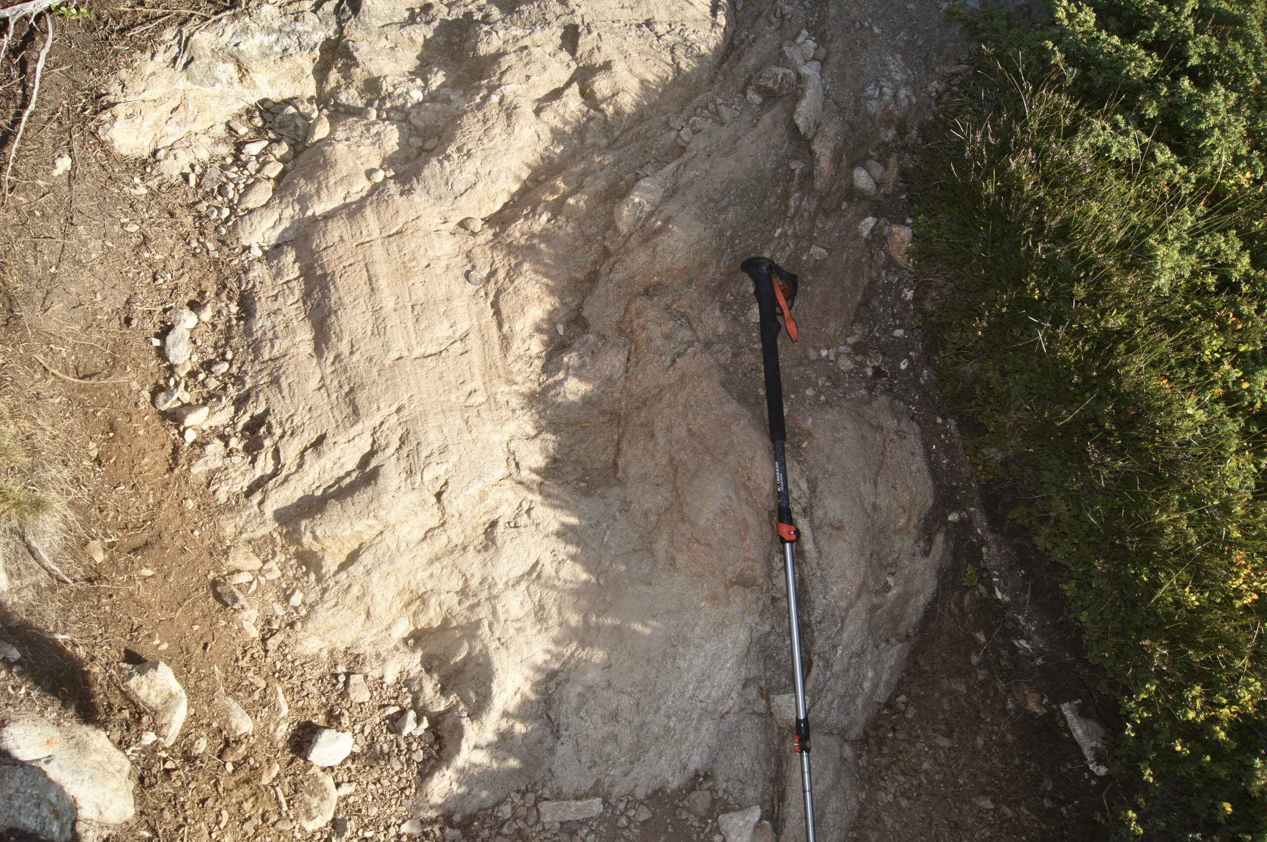
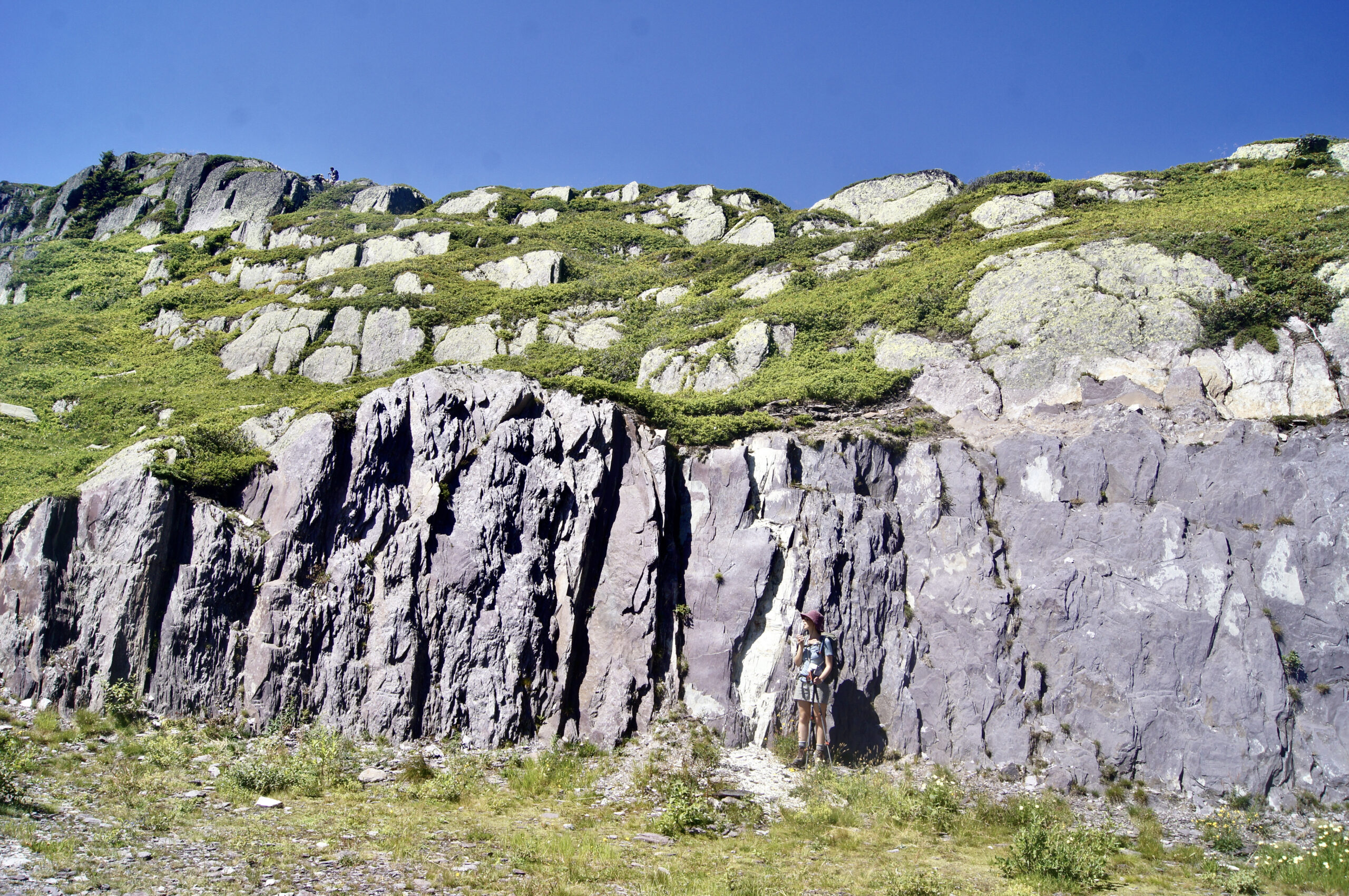
You are walking along the balcony path between Tête-aux-Vents and La Flégère. The landscape shows a stark contrast between the vertical needles and the steep slope of the valley. The flat area of the balcony was carved out by large glacial tongues that wound between the needles during past glacial periods (115,000 to 11,000 years ago). Glaciers are powerful agents of erosion, abrading and plucking rock fragments as they move. The eroded rocks, polished and rounded, are typical features of glacial activity and are known as sheepback rocks. These rocks sometimes display parallel striations, aligned with the direction of the glacier’s movement. In the photo, the hiking pole has been placed perpendicular to these striations.
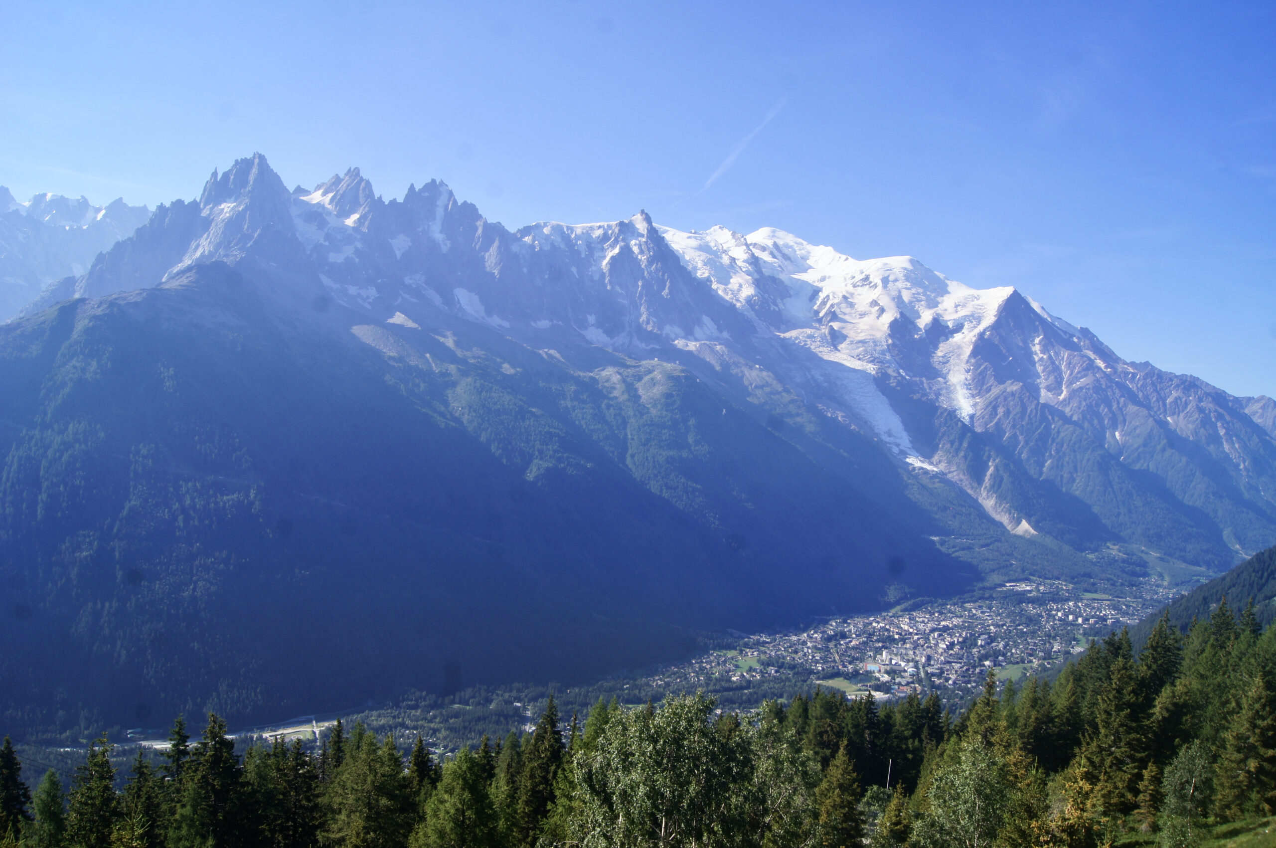
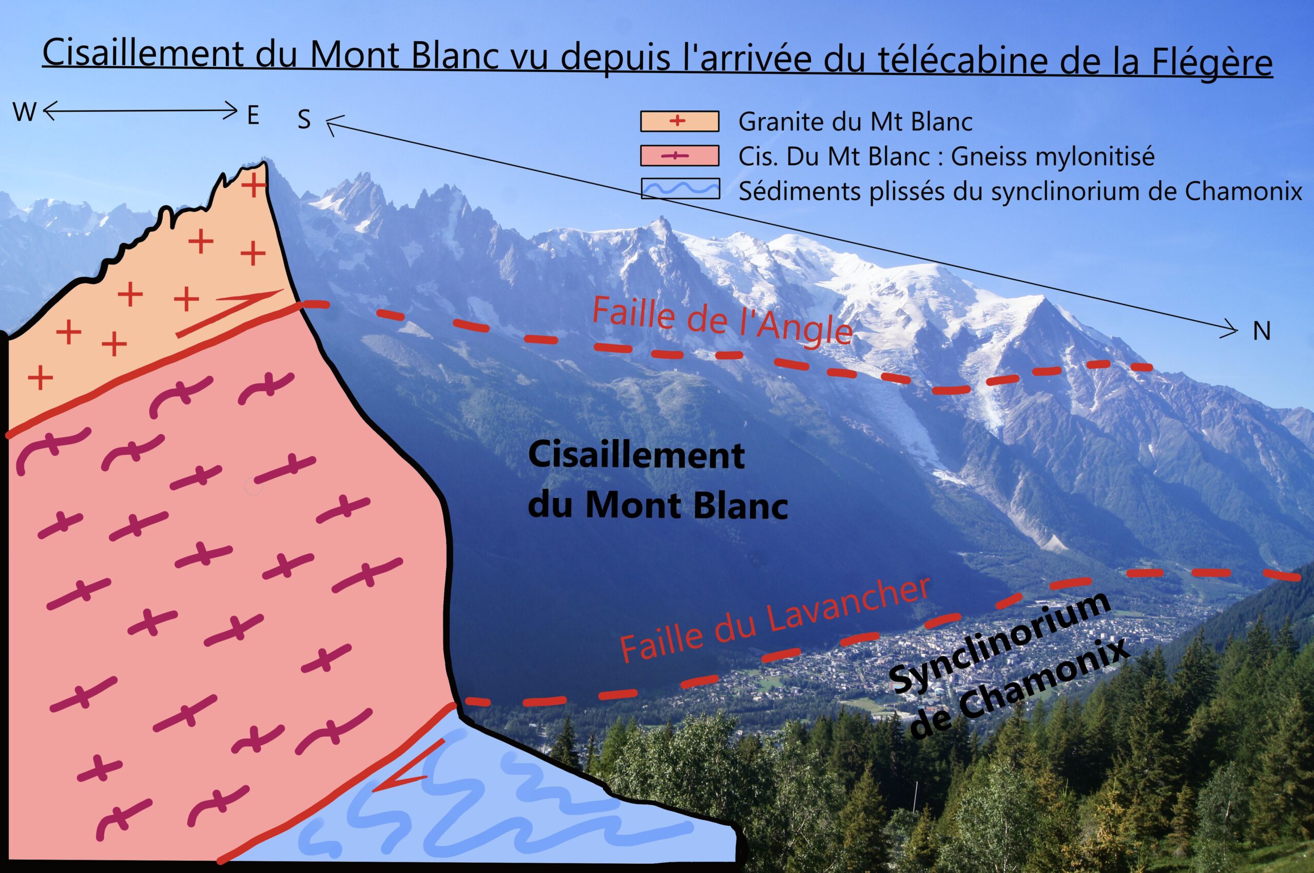
Here, we can address part of the question: why is Mont Blanc so high? Before you lies a noticeable break in the slope that marks the Mont Blanc massif at approximately 2,200 metres in elevation. This is the Angle Fault. Between this fault and the valley floor lies a significant deformation zone known as the Mont Blanc shear zone. The sediments found in the Chamonix valley belong to a nappe that was thrust over Mont Blanc between 30 and 22 million years ago. From 22 million years ago until about 6 million years ago, the basement rock was also forced above the sedimentary cover due to the reverse movement along the shear. The vertical displacement resulting from this tectonic activity is estimated to be between 9.5 and 13 kilometres.
Sources
- A. Mercier, P.H. Leloup, G. Courrioux, S. Caritg, S. Lopez, P. Grandjean, S. Passot, A. Kalifi, “Large thrusting and late faulting shape the Aiguilles Rouges crystalline massif (Western Alps), structural implications”, Tectonophysics, Volume 847, 2023, 229691, ISSN 0040-1951, https://doi.org/10.1016/j.tecto.2022.229691
- Hervé Leloup et Serge Drouet, Vallée de Chamonix : massif du Mont Blanc, Les Guides Géologiques Omniscience, 2015
Brévent Lake, visible as you descend from Brévent towards Les Houches, is a high-altitude lake located within the Aiguilles Rouges Nature Reserve. This small lake (2.4 ha) was formed by glacial erosion. It is quite unique: small, shallow (less than 20 metres deep), and with minimal circulation between its surface and bottom layers. Frozen for more than eight months of the year, its waters are extremely low in nutrients, making it unsuitable for the development of most flora and fauna. Fish were introduced in 1906, but no species could thrive naturally, except minnows. Since 2010, fish stocking has ceased, as the lake’s ecosystem is too unbalanced to support sustainable fish populations.
Sources
- Carole Birck, “Lac du Brévent”, Réseau lacs sentinelles publié en 2015, consulté en 2024, URL : https://www.lacs-sentinelles.org/fr/lacs/lac-du-brévent
- M.Beaufils et P.Huchet, “Echantillonnage piscicole des 5 lacs d’altitude du Faucigny – Bilan des effets du changement du plan de gestion”, Fédération Départementale pour la Pêche et la Protection du Milieu Aquatique, 2015, URL : https://www.pechehautesavoie.com/wp-content/uploads/2016/04/Bilan_piscicole_lacs_de_montagne_Faucigny.pdf
We couldn’t descend from Brévent without highlighting the stunning mineral that sparkles like beautiful glitter throughout this part of the Aiguilles Rouges massif: muscovite, a type of white mica. Micas are phyllosilicates, meaning they are silicate minerals arranged in layered structures. Both white and black micas exhibit a metallic sheen, creating a “disco ball” effect across the landscape. In this region, muscovite accentuates the schistosity of the rocks. Its formation coincided with the tectonic deformation that shaped the rock layers. This metamorphic mineral is rich in aluminium, and the abundance of muscovite in the Brévent micaschists suggests that the original rock—known as the protolith—was also rich in aluminium (pelitic) before undergoing metamorphosis during the Variscan orogeny.
Sources
- J.L Panais, J. Bellière, J.Rosset, Notice de la carte géologique de Cluses, BRGM, 1992
Les Houches marks the lowest point on the Tour du Mont Blanc, located in the collinean zone, which extends up to around 1100 metres. This is the zone of villages, historically dedicated to agriculture and now largely characterised by leafy woodlands. Before reaching the altitude where spruce trees take over (indicating the start of the montane zone), you can spot a variety of trees along the paths, including sycamores, birches, ash trees, and white alders. This zone has undergone notable changes over the past century. In the 20th century, agricultural specialisation led to a decline in farming activities. Food crops and fodder production gradually diminished and eventually disappeared, allowing open land to give way to leafy forests. Since the 1970s, with the rise of tourism, residential development has spread, bringing further transformation to the landscape.
Sources
- Comparateur de photos de l’IGN : IGN remonter le temps, Les Houches, URL : https://remonterletemps.ign.fr/comparer/?lon=6.790162&lat=45.893937&z=13&layer1=10&layer2=19&mode=split-h
- Claire, “Le bonheur est dans le pré”, site de l’office du tourisme de Chamonix, mis en ligne en 2023, consulté en 2024, URL : https://www.chamonix.com/infos-et-services/espace-presse/le-bonheur-est-dans-l-alpage
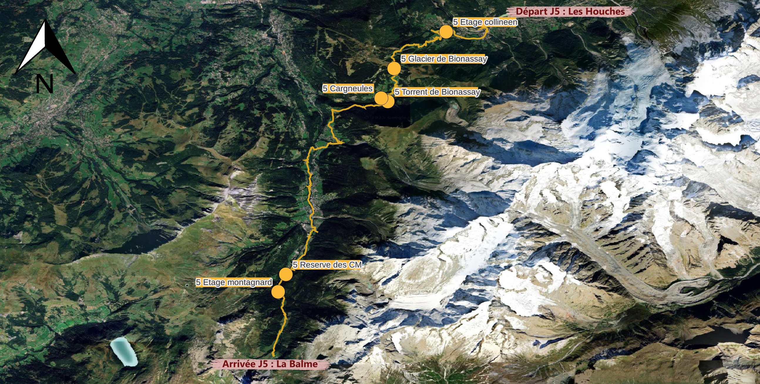
You are at the Voza Col. Looking towards Mont-Blanc, you can see the Bionassay Glacier flowing down into the valley. Beneath this larger glacier lies a smaller one, the Tête-Rousse Glacier, which is hidden from view. On the right slope of the Bionassay, also invisible from the valley, the Tête-Rousse Glacier became infamous during the night of July 11–12, 1892, when a large water pocket in its front section ruptured. Several million cubic metres of water surged down the mountain, devastating the villages below and the Saint-Gervais thermal baths. The flood claimed the lives of 175 people. In 2010, another water pocket was identified, but it was safely emptied between September and October of that year to prevent another disaster.
Sources
- A.Gilbert, C.Vincent, P.Wagnon, E.Thilbert, A.Rabate, “The influence of snow cover thickness on the thermal regime of Tête Rousse Glacier (Mont Blanc range, 3200 m a.s.l.): Consequences for outburst flood hazards and glacier response to climate change”, 2012, Journal of physical research https://doi.org/10.1029/2011JF002258
- Hervé Leloup et Serge Drouet, Vallée de Chamonix : massif du Mont Blanc, Les Guides Géologiques Omniscience, 2015
- Jean-Baptiste Bosson, Nicola Deluigi, Tania Ferber, Déodat Bonneaux, Stephan Utz et Lucien Grangier, Derrière le paysage, consultation en 2024, URL : https://www.cen-haute-savoie.org/sites/contamines/index.html
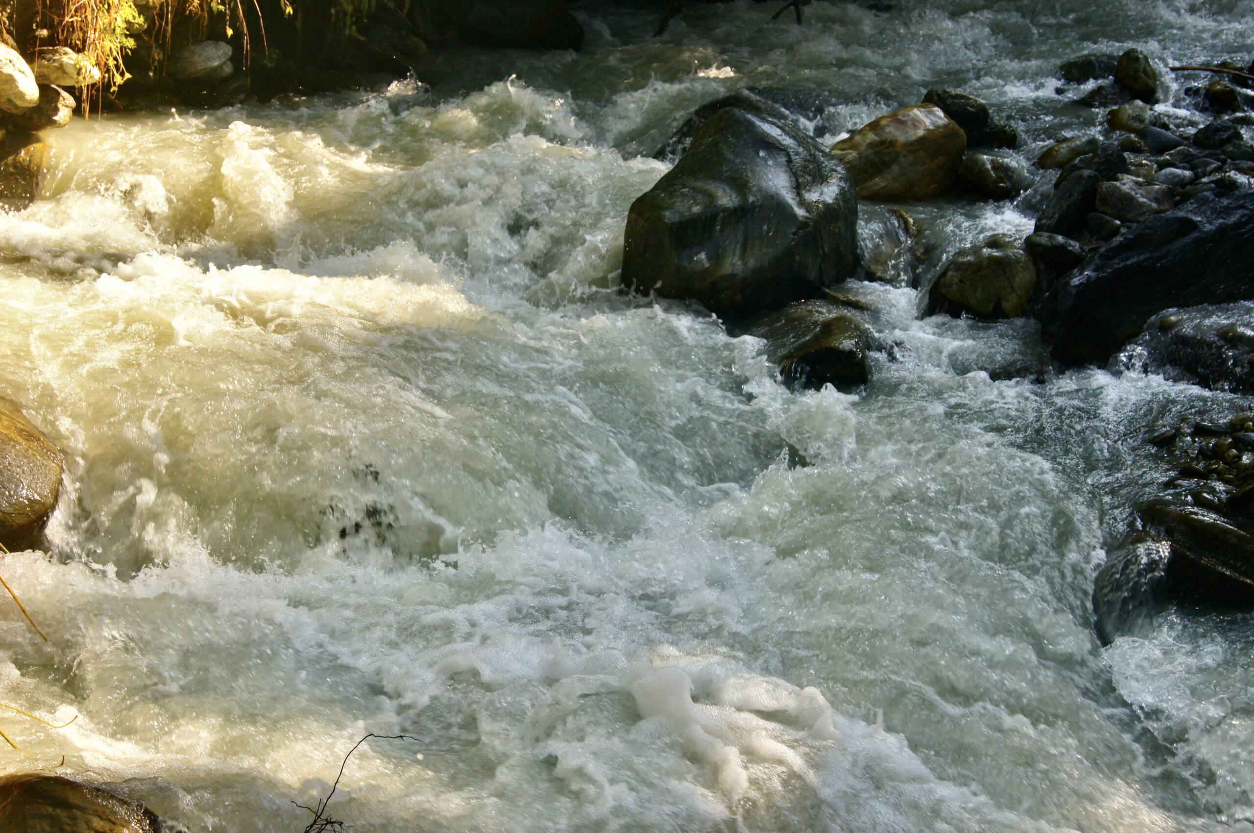
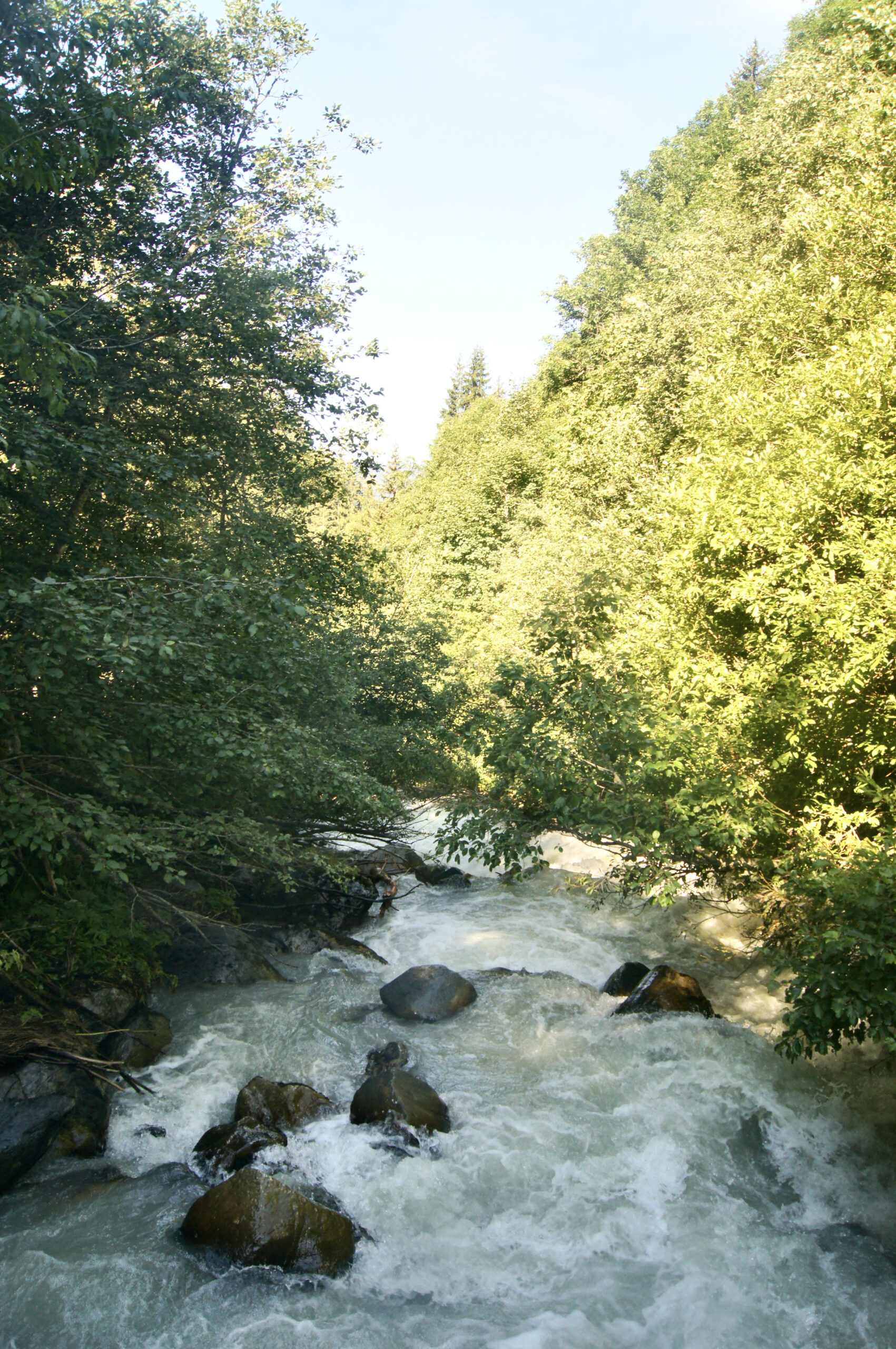
Have you noticed the whitish tint of the Bionassay stream? This stream is primarily fed by meltwater from the Bionassay Glacier. As the glacier moves, it grinds the surrounding rocks into an extremely fine powder known as glacial flour. This powder becomes trapped between the rocks and the glacier, eventually carried away by the melting water, which mixes with the stream and rivers. The glacial flour remains suspended in the water, giving glacial streams like the Bionassay their characteristic whitish colour.
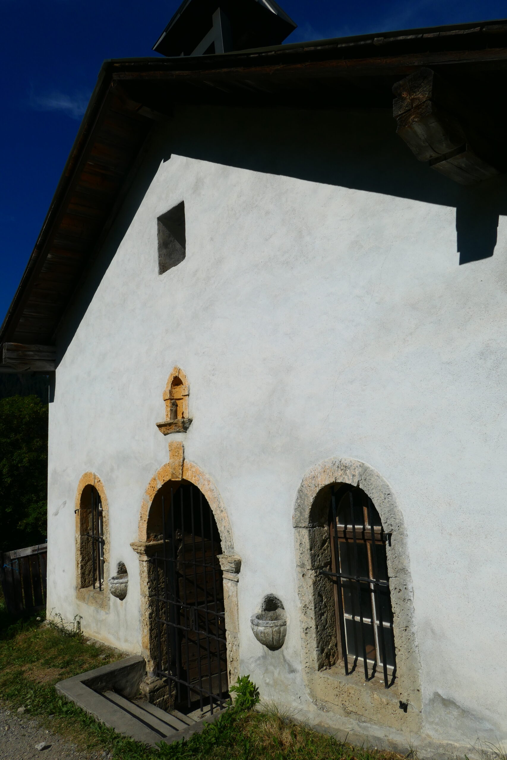
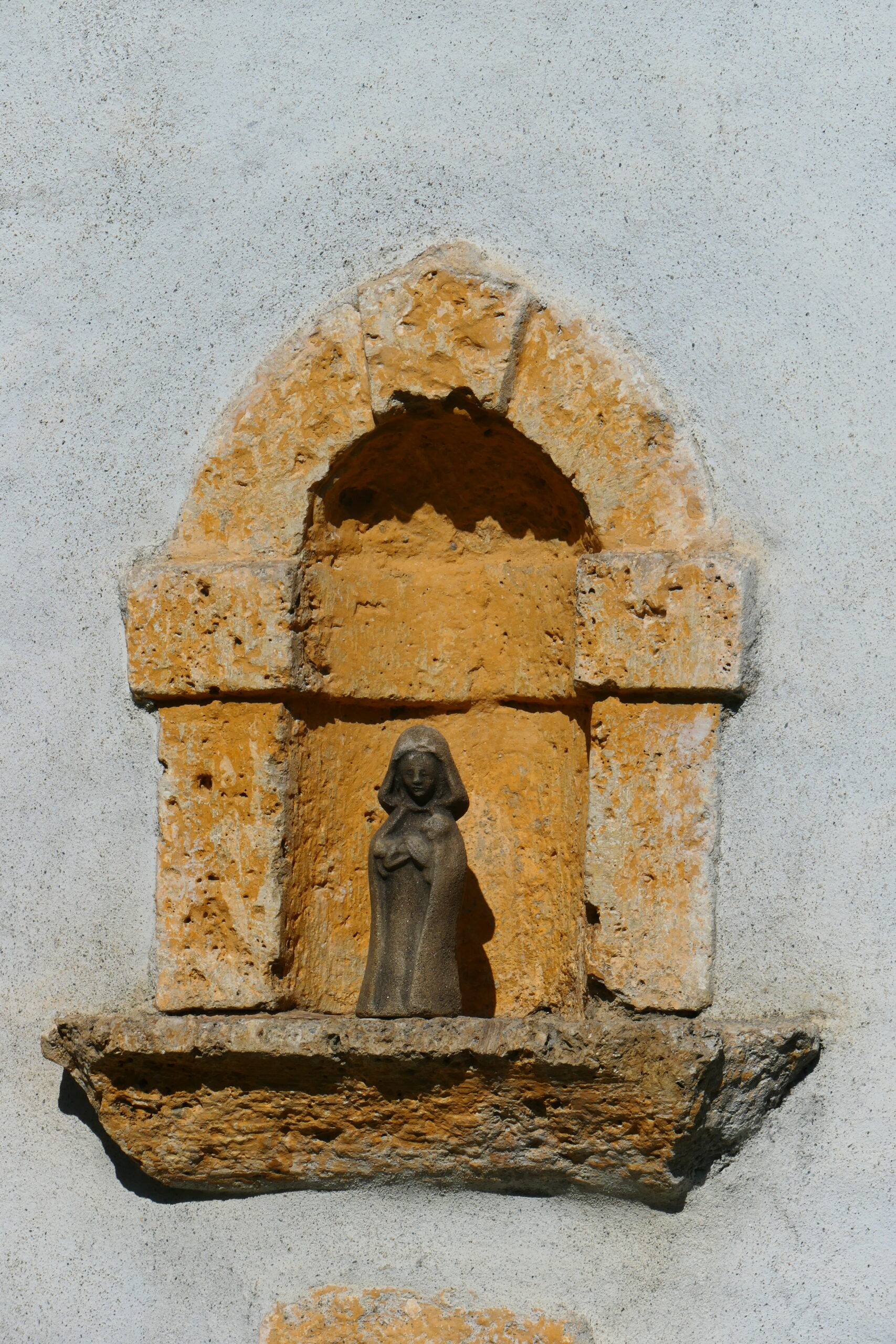
Have you noticed the rocks around the door, windows, and niches of the Bionassay chapel? These rocks are cargneules, recognisable by their orangish colour and porous texture. Cargneules are often mineralised with pyrite, a mineral composed of iron sulphide. When pyrite degrades, it forms sulfur and iron oxide deposits, which are responsible for the yellow-orange colour of cargneule rocks. In the Mont Blanc massif, cargneules are often associated with the Triassic geological system, which also includes other types of rocks, such as gypsum. Gypsum, a very ductile white rock that forms in evaporation-prone environments, plays an important role in concentrating deformation along weakness zones due to tectonic movements. It also contains water, which can be released under the effect of pressure and temperature, facilitating the formation of cargneules near fault zones.
Sources
- Léon Moret, “la géologie des environs de Saint Gervais Les Bains (HAUTE-SAVOIE) et ses relations avec la nature et Forigine des Sources Thermo-Minérales”, 1932, URL : http://geologie-alpine.ujf-grenoble.fr/articles/GA_1932__16_2_191_0.pdf
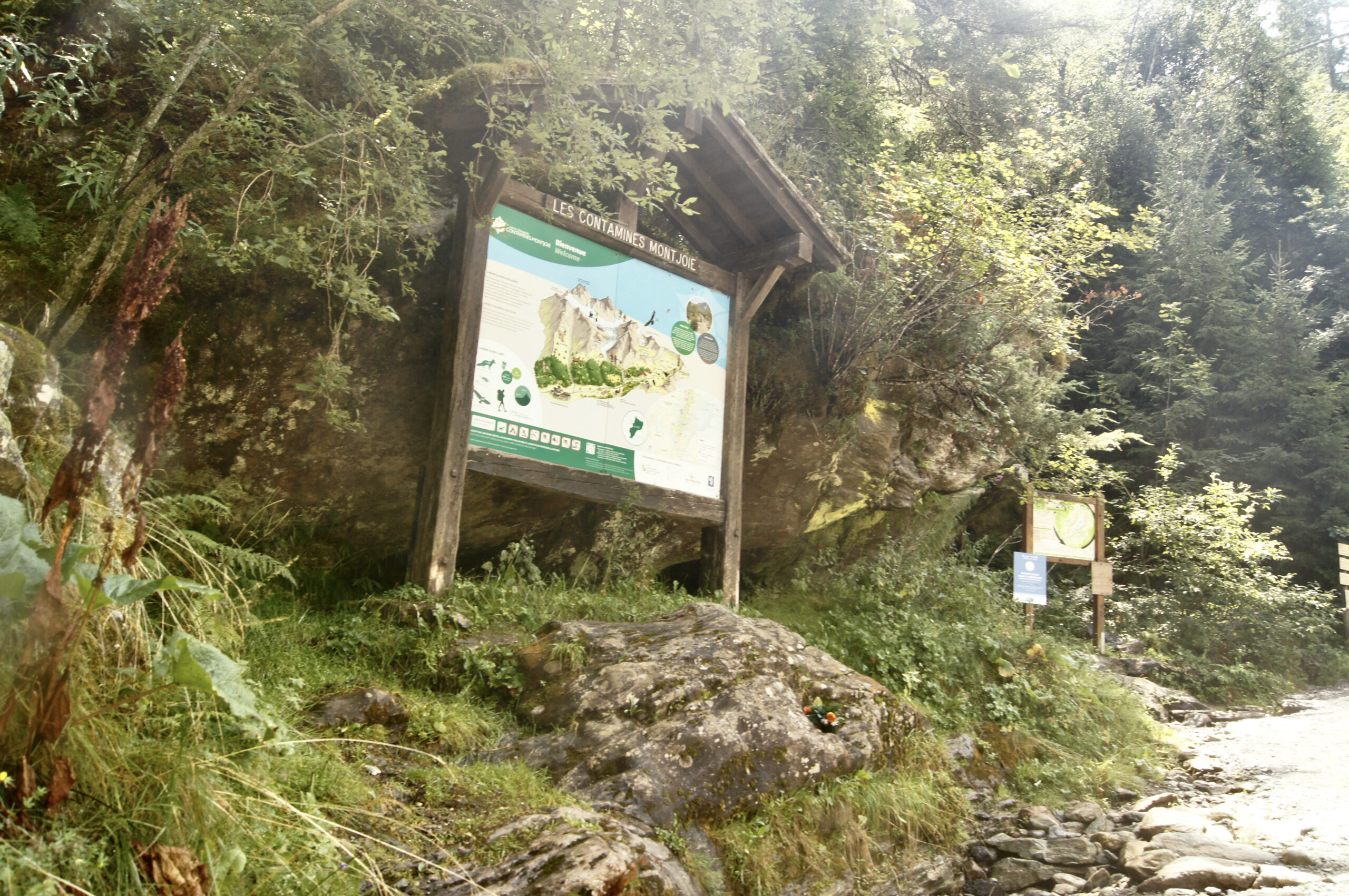
As you climb towards Nant Borrant, you enter the Contamines-Montjoie Nature Reserve. Established in 1979, the reserve covers 5 500 hectares, stretching from the village to the Aiguilles of Tré-La-Tête (3 892 m). It spans from mountain to nival levels, encompassing a rich biodiversity. These natural areas are highly sensitive, and it is crucial that we work together to protect them. To avoid disturbing wildlife (stress, nest destruction, etc.), please keep your dog on a lead and camp only in designated areas. Do not pick flowers, and stay on marked trails to prevent damage to fragile plant species. Take all your litter with you, and avoid lighting fires. You can find the full regulation here.
As you traverse the spruce forest, you are in the heart of the montane and lower subalpine zones, where spruce trees are the dominant conifer species. But how can you recognise a spruce tree? Unlike fir trees or Douglas pines (which are absent from this massif), spruce needles are individually attached to the branches. You can easily identify spruce trees by their drooping branches, pendulous cones, and the diamond-shaped cross-section of their needles. Spruce forests are experiencing significant expansion in the massif, primarily linked to agricultural abandonment and glacier retreat since the 19th century. However, you may also notice some yellowish spruce trees; this discoloration is caused by a beetle known as the bostryche typographe, which infests the trees.
Sources
- Nathalie Petrel, “L’épicéa commun”, Office National des Forêts, consulté en septembre 2024, URL : https://www.onf.fr/vivre-la-foret/raconte-moi-la-foret/comprendre-la-foret/explorer-la-nature-en-foret/%2B/1c92::lepicea-commun.html
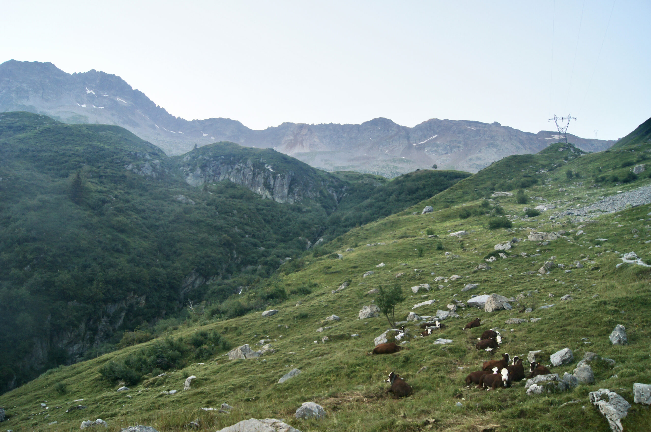
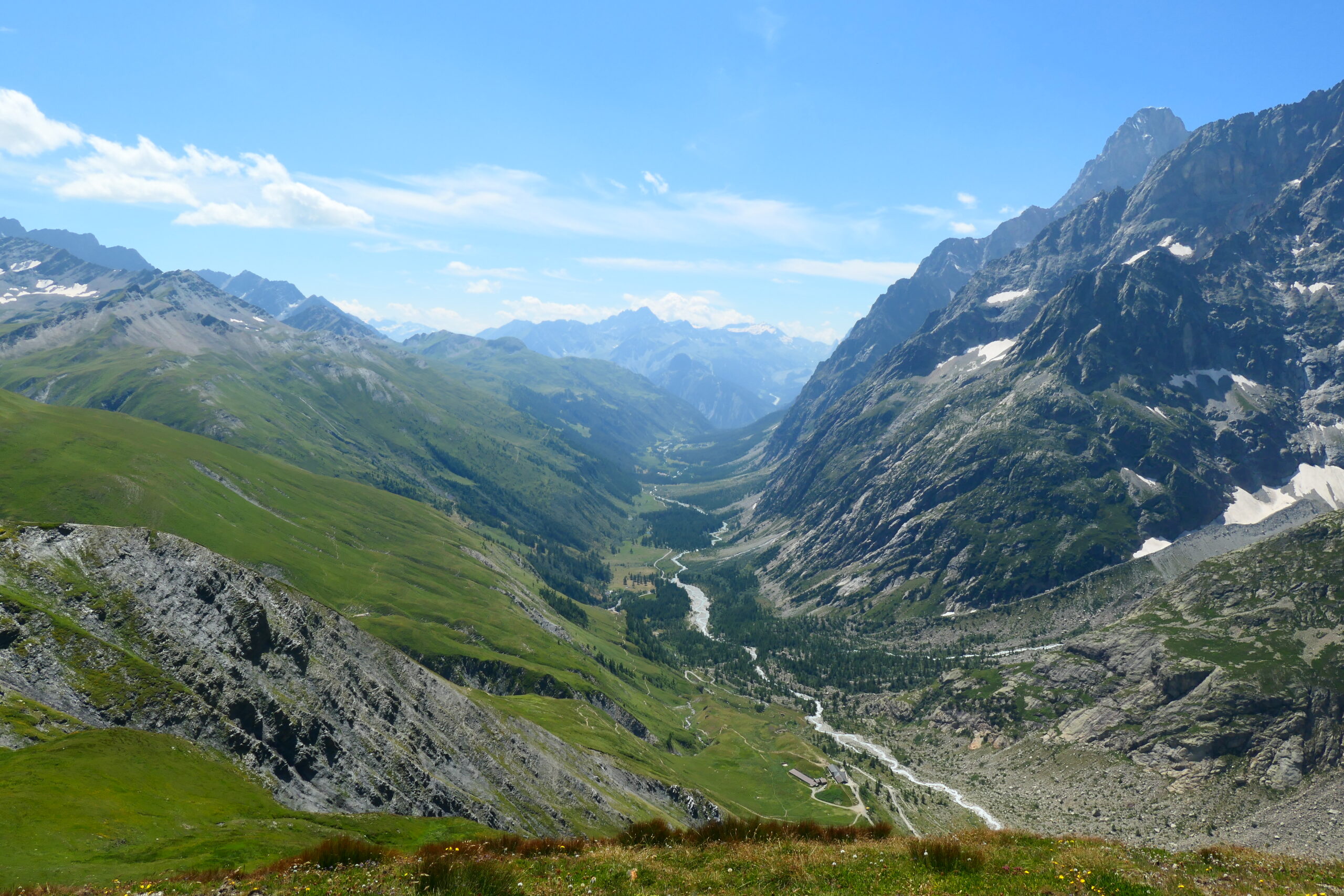
Leaving the mountain pastures of La Balme and heading towards the Col du Bonhomme, the valley gradually tightens, though it never fully closes. This shift in topography marks a valley threshold or valley step: an area that has more successfully resisted glacial erosion. Here, the glacier’s descent slowed, leading to the formation of an over-deepened area upstream of the step. Change in glacial valley’s slope can be explained by differences in lithology. In this case, the valley step corresponds to the presence of Mont-Blanc gneiss, a resistant rock, whereas upstream and downstream of the steps are schists, softer sedimentary rocks.
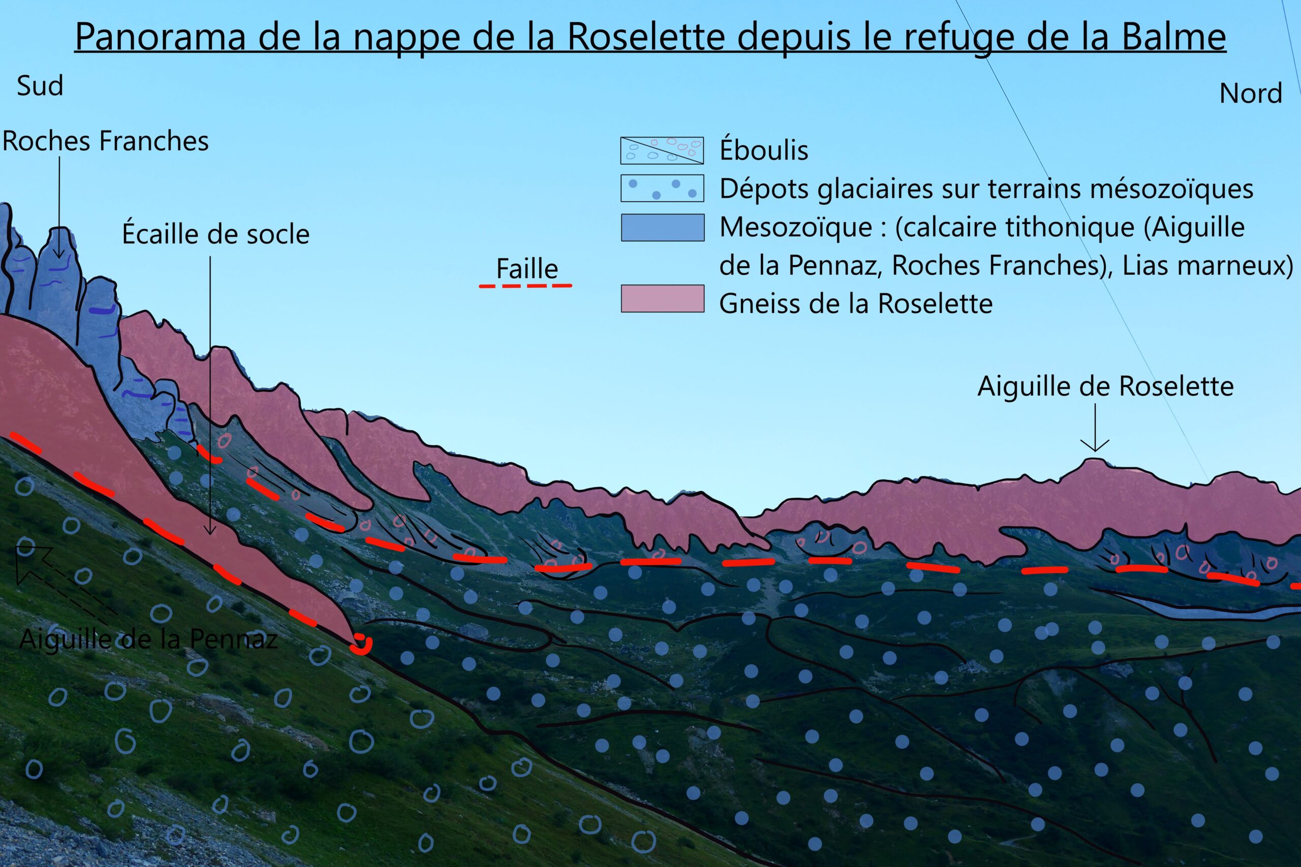
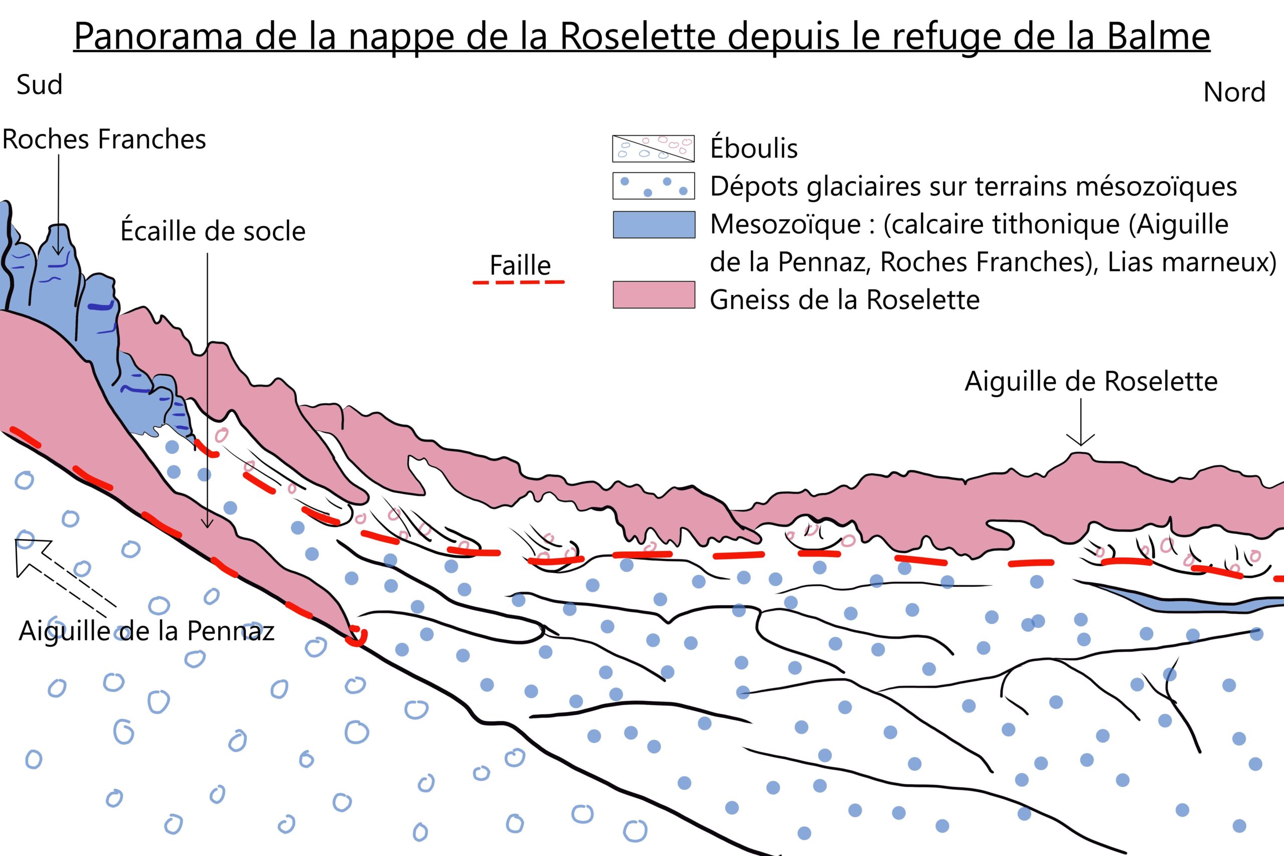
From upstream of the Balme cabin, looking west, you can distinguish the grey, folded sedimentary units—such as the Pennaz Needle, Roches Franches, and Tihonique limestones—of the Upper Jurassic, layered over the softer sedimentary marls of the Lower Jurassic Lias. The marls are characterised by their gentle topography, contrasting with the darker, chaotic gneissic basement units beneath them. These geological units belong to the Roselette Nappe, which was transported approximately 8 kilometres from southeast to northwest between 30 and 15 million years ago. The basement units form the core of the Roselette and are in an unusual position, with ancient crystalline rocks resting above younger sedimentary layers. This configuration suggests a double thrusting mechanism: first, the movement of the Roselette Nappe, followed by the thrusting of the Roselette core over it.
Sources
- Matthieu Petetin, “Structures géologiques, lecture géologique des paysages”, geologie-montblanc, consulté en 2024, URL : http://www.geologie-montblanc.fr/structures.htm
- Hervé Leloup et Serge Drouet, Vallée de Chamonix : massif du Mont Blanc, Les Guides Géologiques Omniscience, 2015
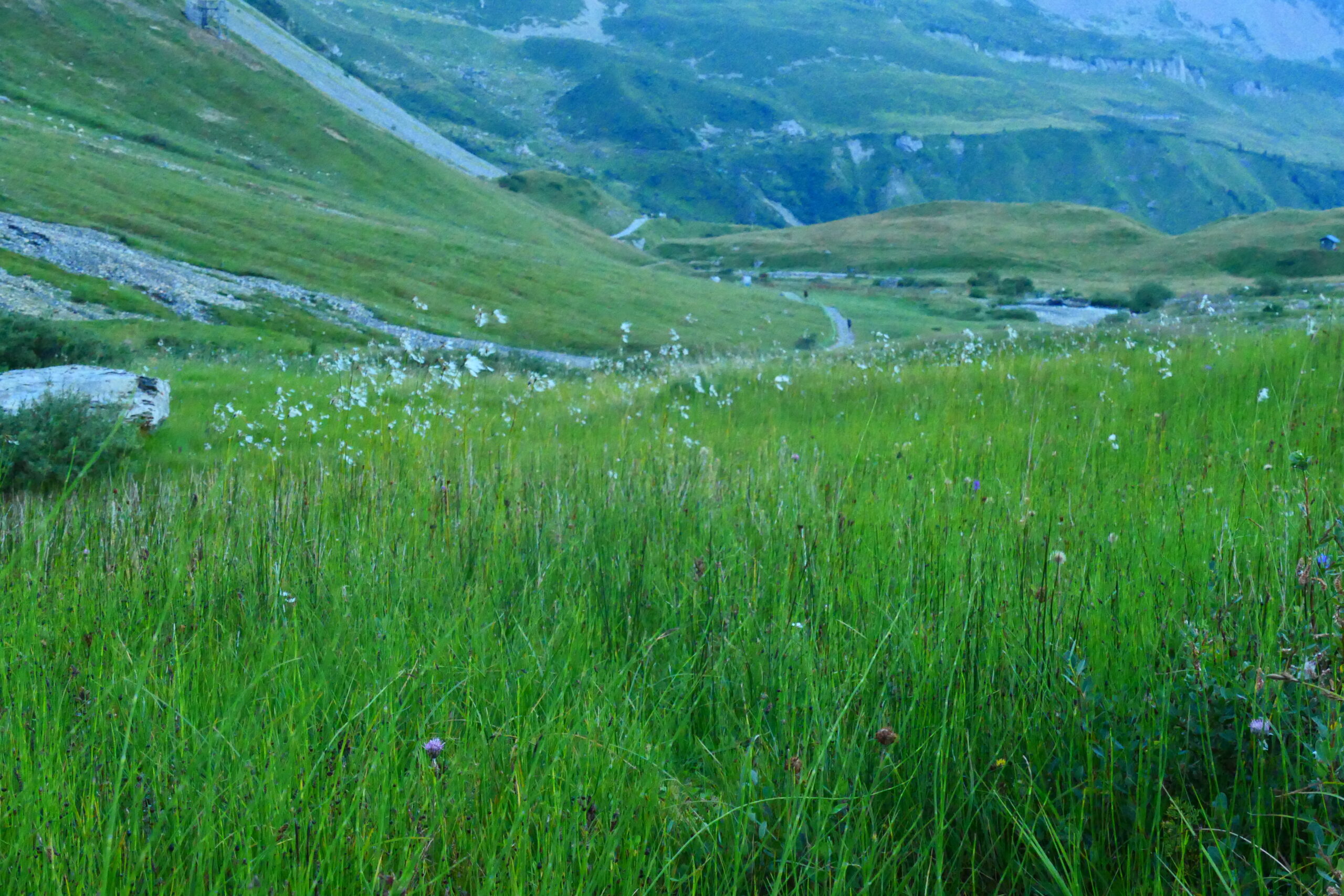
The path crosses a humid zone where you can recognise the small, fluffy panicles of narrow-leaved cotton grass (see picture), along with horsetails and lycopods. Bogs represent the natural progression of a mountain lake: at high altitudes, organic matter decomposes slowly, gradually filling the lake over time. This creates a suitable environment for hygrophilic flora, such as the plants found at Plan Jovet. Although bogs cover only about 3% of the Earth’s surface, they store approximately 25% of the world’s soil organic carbon. Additionally, these unique ecosystems provide scientists with valuable information about the life in the massif thousands of years ago, primarily through the study of pollens.
Sources
- ASTERS (LOPEZ-PINOT D.), .- 820031667, Tourbières de Plan Jovet. – INPN, SPN-MNHN Paris, 29P. 2024, https://inpn.mnhn.fr/zone/znieff/820031667.pdf
- Francois De Vleeschouwer, Laure Gandois, “Les réserves en carbone des tourbières ne peuvent plus être ignorées”, CNRS Terre et Univers, publié en 2020, consulté en 2024, URL : https://www.insu.cnrs.fr/fr/cnrsinfo/les-reserves-en-carbone-des-tourbieres-ne-peuvent-plus-etre-ignorees
On the climb to the Col du Bonhomme, the path winds through two distinct types of rock: layered grey rocks and yellow rocks with small cavities. These sedimentary rocks were formed on the floor of the ancient Tethys Ocean, which opened during the Triassic period as the supercontinent Pangaea broke apart. During the Upper Triassic (around 220 million years ago), the grey rocks, known as argillites, were deposited in a shallow marine environment. As the basin gradually deepened, magnesium carbonates deposited during the Lower Jurassic (around 175 million years ago). These carbonates were partially dissolved by fault movements, creating cargneules—the distinctive yellowish, cavity-filled rocks. These sponge-like rocks are characteristic of the Mont Blanc shear zone. The layers have been folded and tilted over time during the uplift of the Mont Blanc massif (around 15 Ma).
Sources
- Hervé Leloup et Serge Drouet, Vallée de Chamonix : massif du Mont Blanc, Les Guides Géologiques Omniscience, 2015
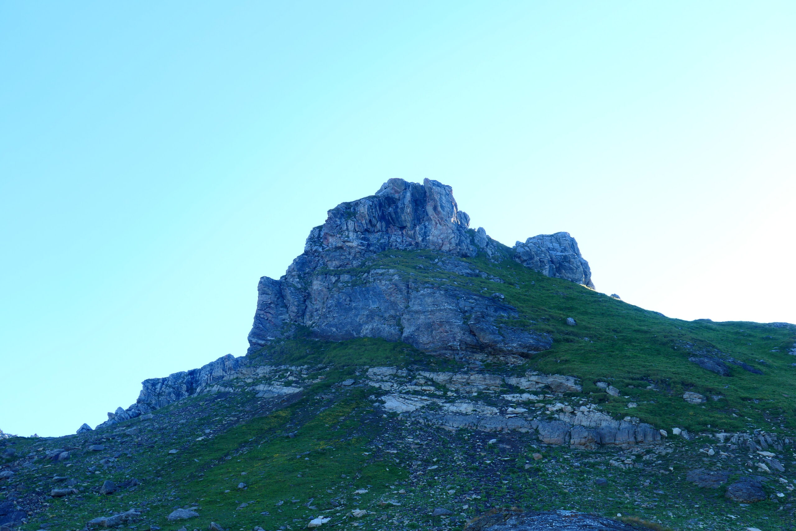
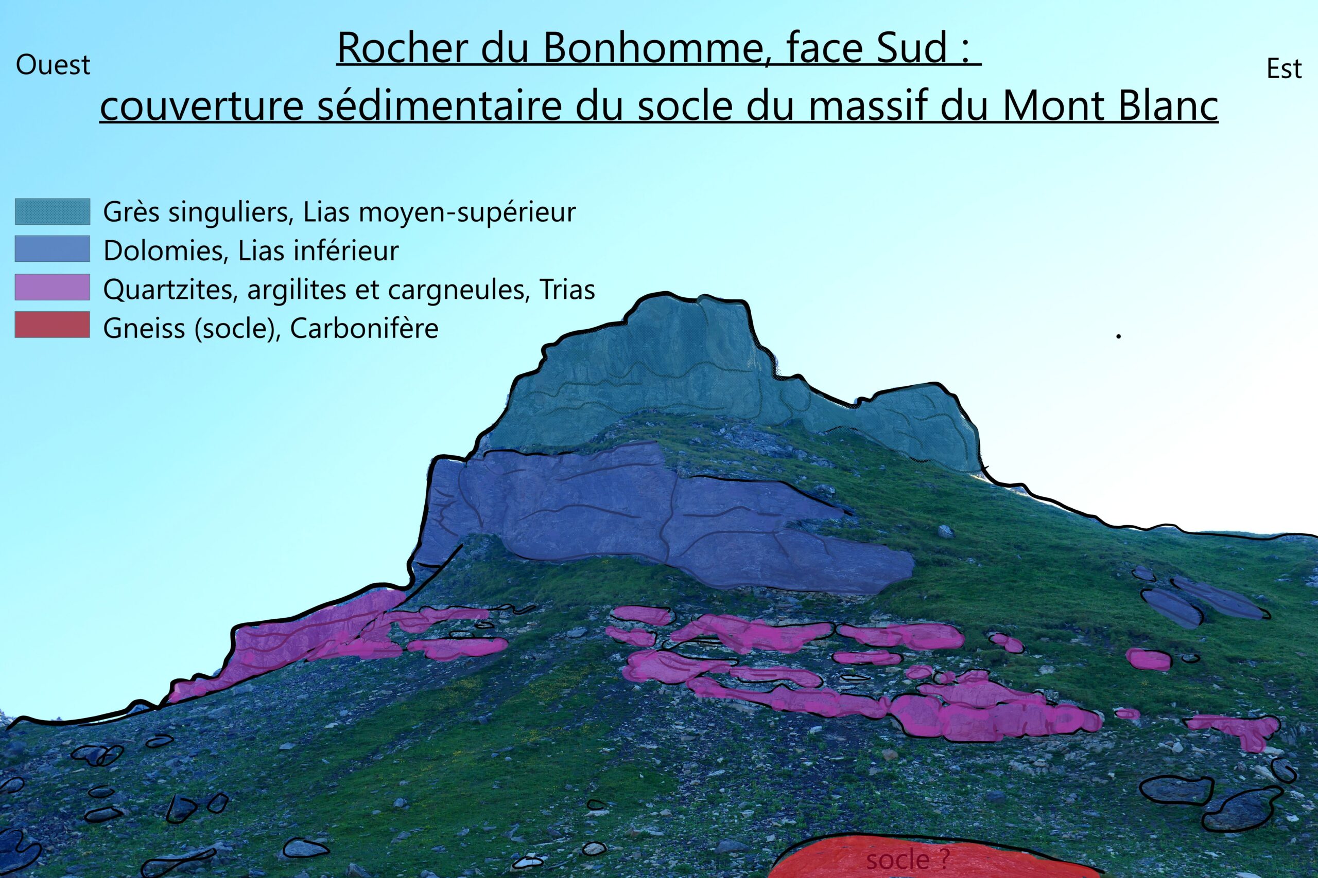
To the north, you can spot the Rocher du Bonhomme. There is no fault separating the sediments of this formation from the basement rock on which the path lies; the sediments of the Bonhomme rock formation represent the autochthonous cover of Mont Blanc. From bottom to top, the typical Triassic layers of the Alps consist of cargneules, argillites, and quartzites, then the Lower Lias limestone. Above these layers lies the Middle Lias, composed of sandstones containing eroded fragments from the basement. These sandstones show signs of alteration during the same geological period, indicated by the presence of iron oxides and hydroxides. This suggests that these sandstones experienced emergence, even as much of the region was submerged beneath the sea. During the Middle Lias, the Mont Blanc massif was a high seabed.
Sources
- Hervé Leloup et Serge Drouet, Vallée de Chamonix : massif du Mont Blanc, Les Guides Géologiques Omniscience, 2015
This variant from the Col des Fours provides an excellent opportunity to traverse the nival zone. As you climb towards the col, you’ll notice that the vegetation becomes increasingly sparse, eventually giving way to rocks and snow (depending on the season). This marks the altitude of the first permanent snow, typically around 2700 metres, signifying the entrance to the nival zone.While vegetation is much scarcer in this region, it is not entirely absent. Mosses and lichens can survive here, along with other resilient plants like fairy candelabras, saxifrages, and glacier buttercups (particularly beautiful and noticeable during the ascent). These plants find shelter from the wind and cold in the fractures of the rocks or in cushion-like growth forms.
Sources
- “L’écologie des montagnes, Flore et Faune des différents étages, étage nival”, biologie en ligne, université de Lille, consulté en 2024, URL : https://biologie-enligne.univ-lille.fr/montagnes/co/chap5_6.html, https://fr.wikipedia.org/wiki/%C3%89tage_nival
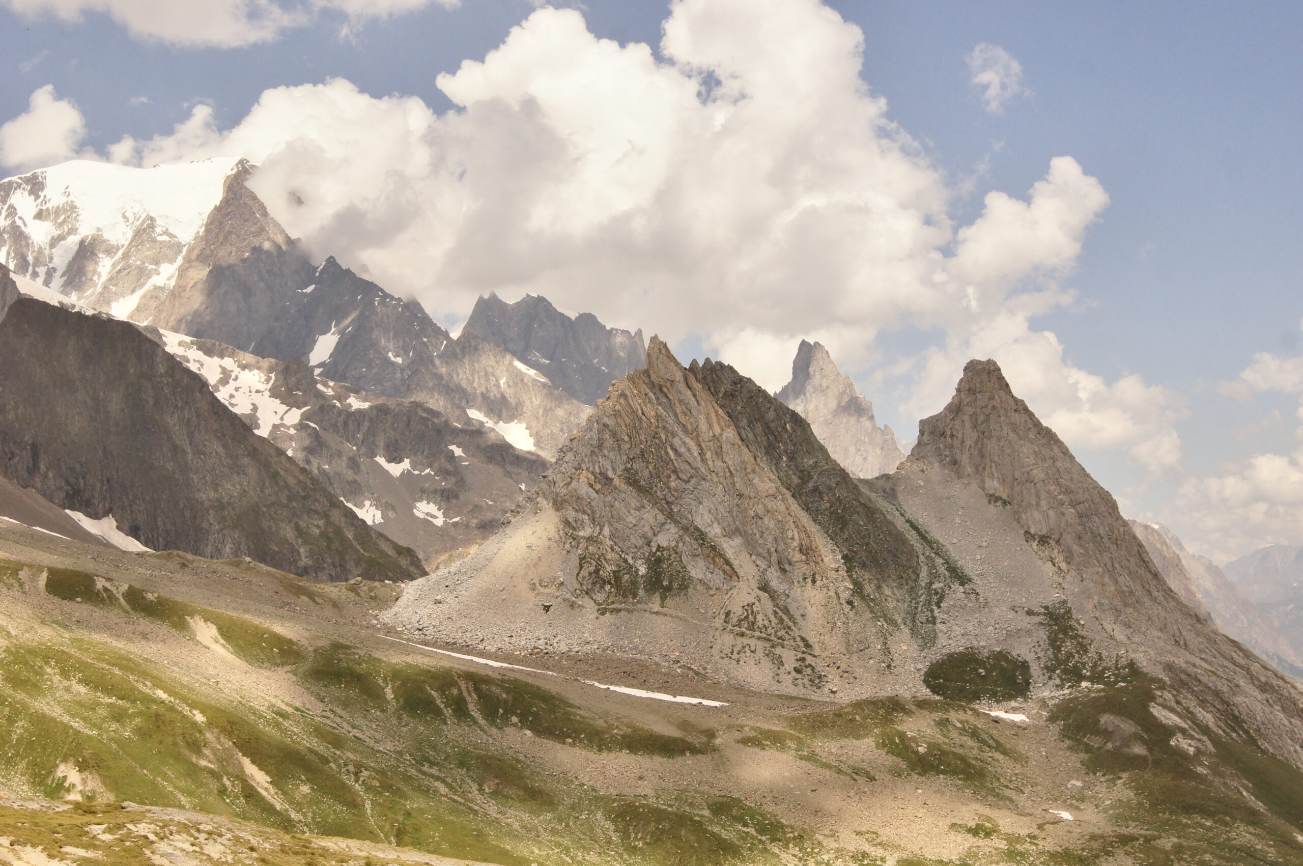
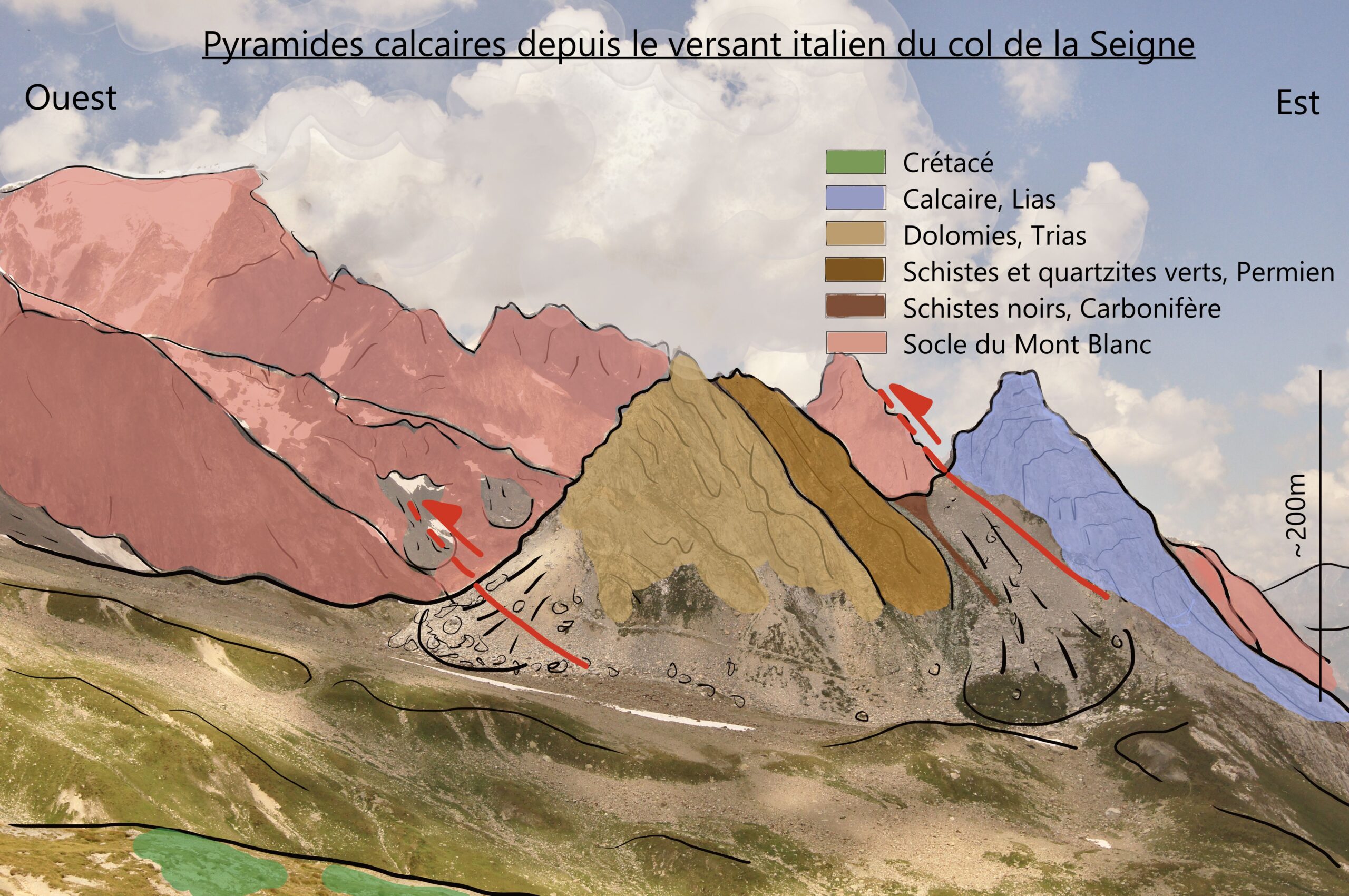
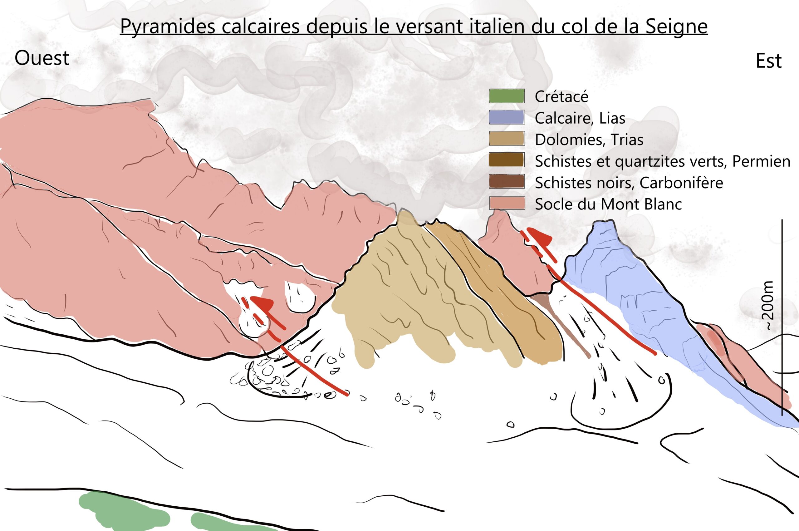
The Col de la Seigne marks the border between France and Italy. On the Italian side, two beautiful pyramids face us, signifying another boundary between the External Alps and the Internal Alps. The western pyramid is composed of Triassic dolomite, while the eastern pyramid is made of Lower Jurassic Lias limestone. Between these pyramids, separated by faults, lies a formation of Permo-Carboniferous rocks. Both pyramids belong to the Tarentaise breccias nappes, a geological unit associated with the sub-Briançonnais zone. This nappe was thrust over the external zones of the Mont Blanc region approximately 35 million years ago. This is the oldest thrust you will encounter while undertaking the Mont Blanc tour.
Sources
- Matthieu Petetin, “Structures géologiques, lecture géologique des paysages”, geologie-montblanc, consulté en 2024, URL : http://www.geologie-montblanc.fr/structures.htm
- Hervé Leloup et Serge Drouet, Vallée de Chamonix : massif du Mont Blanc, Les Guides Géologiques Omniscience, p22, 2015
- G. Mennessier, F. Carme, J. Bellière, P. Antoine, H. Dabrowski, J. Meloux, Notice de la carte géologique de saint Gervais, BRGM, 1977
- Gilles De Broucker, Yves Siméon, Pierre Antoine, Conférence “ L’Océan valaisan et ses marges dans les Alpes du Nord”, UIAD – Grenoble , 22 Janvier 2024, URL : http://www.atelierpaleos.fr/wp-content/uploads/documents/docsconferences/2023-2024/2024-01-22_Oc%C3%A9an-Valaisan/Ocean-Valaisan-Marges-1.pdf
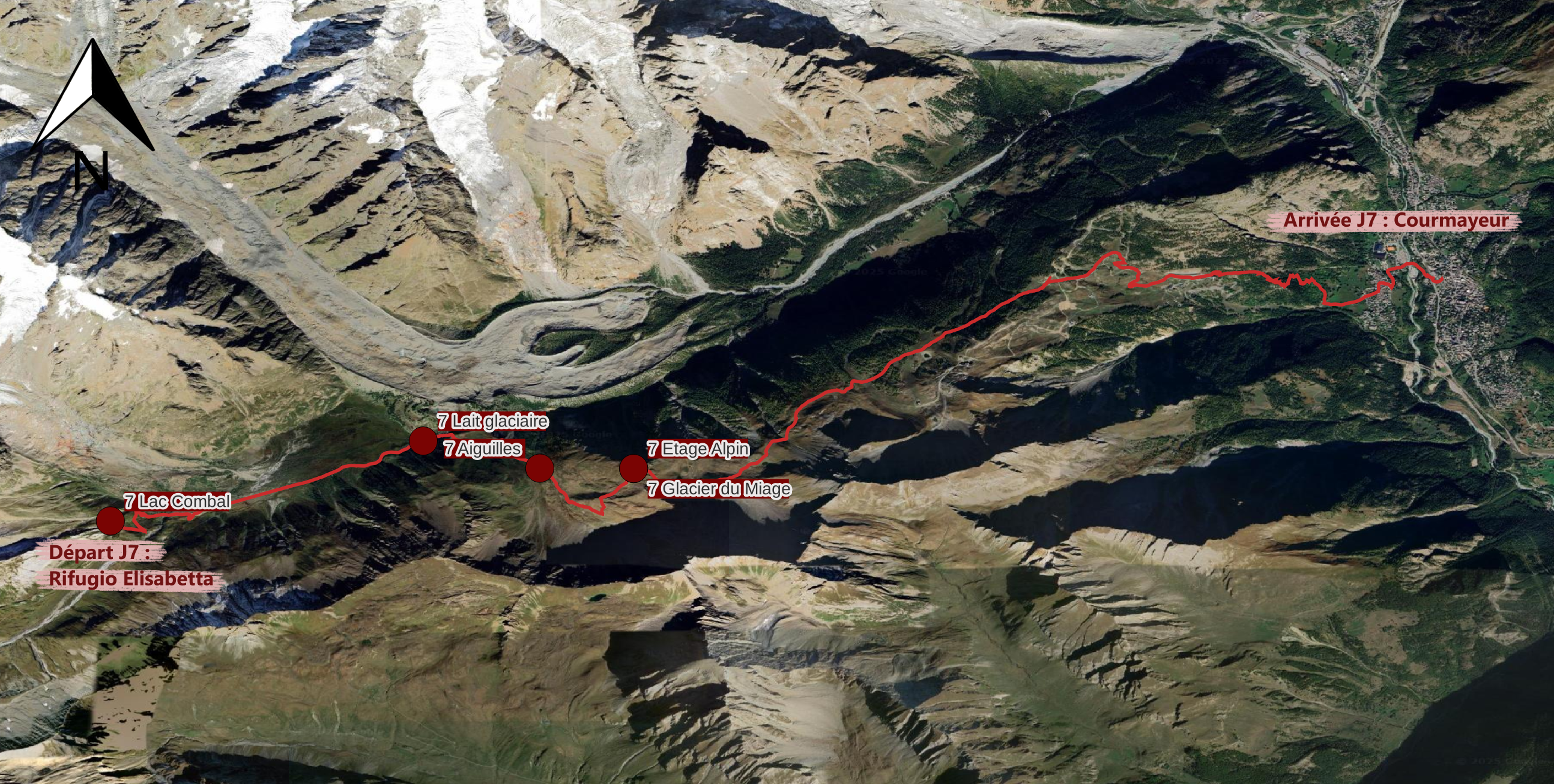
What is now a humid valley floor shimmering below the heights of the Elisabetta cabin was once a lake. The Miage Glacier has blocked the Val Veny with its frontal moraine, creating a natural dam that allows water to accumulate in Combal Lake. Today, this lake is gradually filling with sediments, vegetation, and alluvial forests, interspersed with marshes where streams of water meander.
Sources
- Wikipédia, “Lac de Combal”, dernière modification en 2023, consulté en 2024, URL : https://fr.wikipedia.org/wiki/Lac_de_Combal
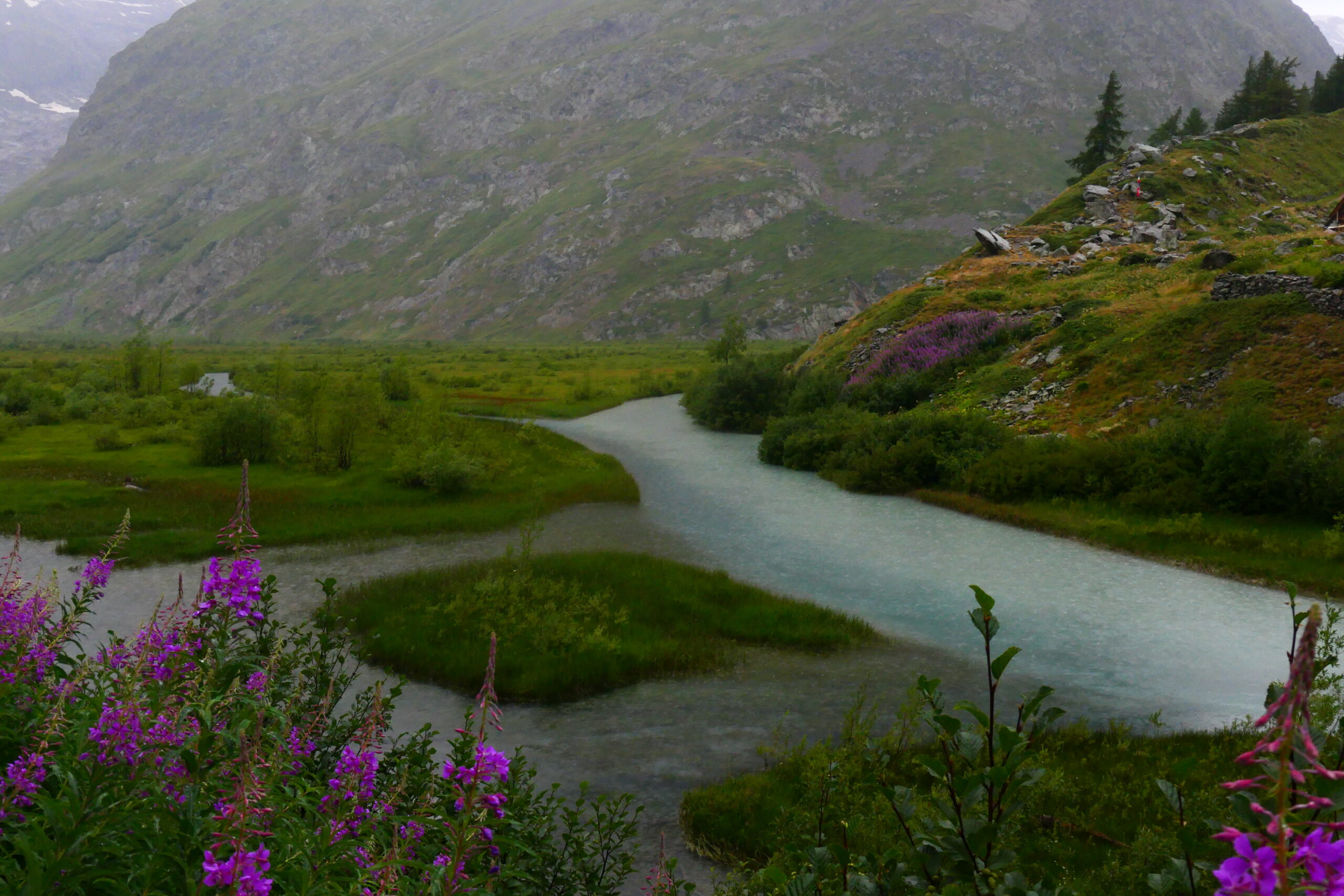
You are at the bottom of Val Veny. The track is easy, and the terrain is almost flat. The valley is bordered on one side by the Seigne Col, which marks the boundary with France, and on the other by the lateral moraines of the Miage Glacier. The formation of these moraines blocked the flow of water, leading to the creation of Lake Combal. Today, filled with sediments, streams wind through the damp meadows. Take a look at the waters and you’ll notice two distinct colours: translucent blue and milky white. The first, blue, is rainwater, which is very pure, while the milky white water is glacial meltwater, rich in sediment (glacial flour). If you were to taste it (not recommended), you would likely detect a gritty, sandy texture.
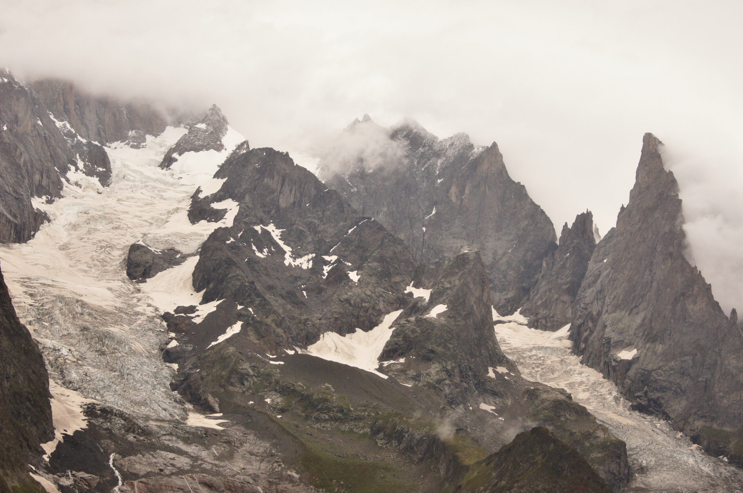
Looking towards the north, you can see the Brouillard Glacier framed by the Brouillard Ridge and Punta Innominata, with the Croux Needle in front of the latter. Further to the right lie the Frêney Glacier and the Noire de Peuterey Needle. These rock needles are the result of erosion caused by repeated cycles of freezing and thawing. The granite, which forms these needles, is crisscrossed by fracture networks called diaclases, where water seeps in. When the water freezes, it expands, breaking the rock apart. Over time, gravity causes the weakened, crumbling rocks to fall away, leading to the formation of these needle-like structures.
Sources
- Xavier Bodin, Philippe Schoeneich, Philip Deline, Ludovic Ravanel, Florence Magnin, Jean-Michel Krysiecki et Thomas Echelard, “Le permafrost de montagne et les processus géomorphologiques associés : évolutions récentes dans les Alpes françaises”, 2015, https://doi.org/10.4000/rga.2806
- Alexandre Aubray, “Les processus d’altération-érosion des granites en climat tempéré vus par l’exemple de chaos granitiques sardes”, Planet-Terre, 2023, URL : https://planet-terre.ens-lyon.fr/pdf/chaos-granitique-Sardaigne.pdf
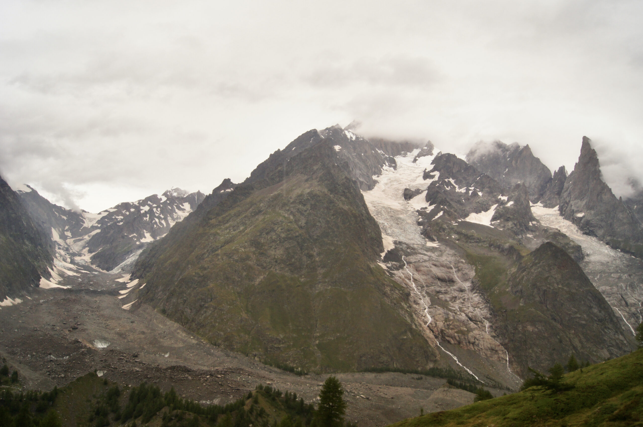
The Miage Glacier stands out from its neighbours to the right, the Brouillard and Frêney glaciers, not only because of its large size but also due to its status as a black glacier and its extensive moraines. Its black colour is caused by a thick layer of debris, about 25 to 30 cm thick, made up of rocks and avalanche material that has fallen from the surrounding slopes. This dark layer helps slow the glacier’s retreat by insulating it from solar radiation. However, the thickness of this debris layer is crucial for it to serve as an effective insulator. If the layer is too thin, it no longer provides enough protection, and since the albedo of rock (being dark) is much lower than that of ice (which reflects more radiation), it would actually accelerate the glacier’s melting rate by absorbing more heat.
Sources
- P. Deline, “Les variations holocènes récentes du glacier du Miage (Val Veny, Val d’Aoste)” [Late holocène fluctuations of the Miage glacier (Val Veny, Valley of Aosta)], Quaternaire, 10-1, p5-13, 1999
- Fyffe, Catriona & Brock, Ben & Kirkbride, Martin & Mair, Doug & Diotri, Fabrizio, “The hydrology of a debris-covered glacier, the Miage Glacier, Italy”, 2012
- Deline Philip, “Arrêt 1 -Un glacier noir remarquable, le Miage (Arp Vieille)”, Collection EDYTEM. Cahiers de géographie, numéro 3, 2005. Le quaternaire des vallées alpines. Fronts glaciaires, mouvements de versants et comblements dans les vallées de l’Arve, d’Aoste et de Suse. Livret-guide de l’excursion organisée par l’AFEQ du 2 au 4 juin 2005. pp. 53-62, doi : https://doi.org/10.3406/edyte.2005.917 https://www.persee.fr/doc/edyte_1762-4304_2005_num_3_1_917
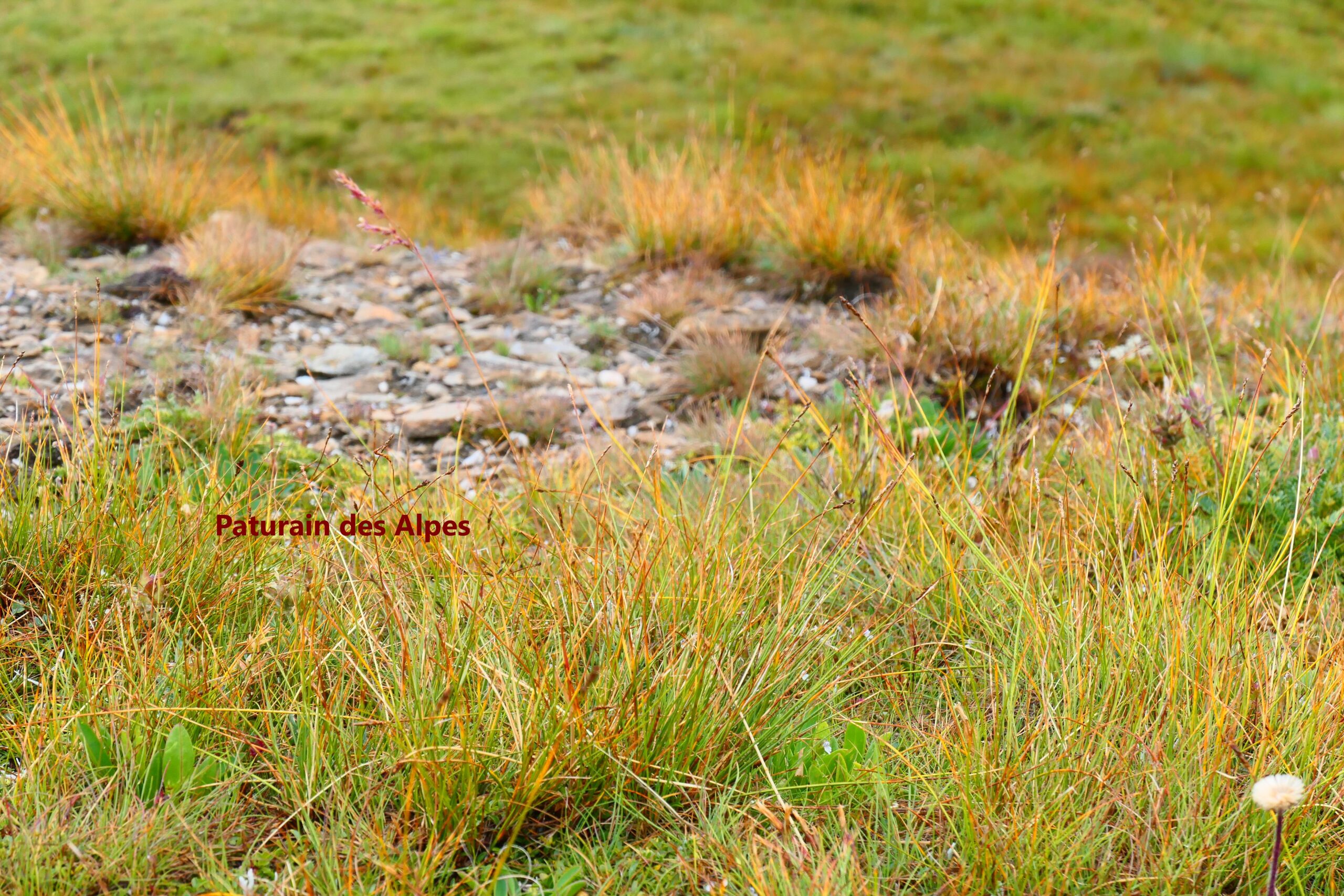
We have reached the final high point of our hike at 2415 metres before descending to Courmayeur. This is an excellent opportunity to learn how to recognise a few species found in the alpine zone. Above an altitude of approximately 2400 metres, the mean annual temperature hovers around 0 °C, and the vegetation period lasts only about 2.5 months. Under these conditions, trees are unable to grow, and we instead observe an alpine lawn that becomes increasingly discontinuous as we ascend. In this alpine lawn, grasses, particularly here alpine meadow grass (see picture), dominate. You can also find numerous species of flowers, including clovers, buttercups, and bellflowers. Remarkably, a tree called the dwarf willow, a relative of the willows found in Arctic forests, can also be spotted in this harsh environment.
GENERAL BIBLIOGRAPHY
- Hervé Leloup et Serge Drouet, Vallée de Chamonix : massif du Mont Blanc, Les Guides Géologiques Omniscience, 2015
- Jean-Baptiste Bosson, Nicola Deluigi, Tania Ferber, Déodat Bonneaux, Stephan Utz et Lucien Grangier, Derrière le paysage, consultation en 2024, URL : https://www.cen-haute-savoie.org/sites/contamines/index.html
- François Michel, Curiosités géologiques de Chamonix-Mont-Blanc, BRGM éditions, 2023
Courmayeur – La Peule
La Peule – Trient
Trient – Tré le Champ
Tré le Champ – Les Houches
Les Houches – Refuge de la Balme
Refuge de la Balme – Rifugio Elizabetta
Rifugio Elizabetta – Courmayeur
We would like to thank A-Ulm for funding DahUlm. Thanks to the Conservatoire des Espaces Naturels (CEN) de Haute Savoie and particularly to Juliette Buret for supporting the project and including some of the stages on the CEN’s RandoNature application.
Thanks to Michel Cara for his answers to our questions and thanks to the popularisation work that preceded us, which was a great help.
Finally, thanks to Marie-Pierre and Claude Rizet for helping us to finalise the preparation of DahUlm in the middle of the mountains.